
-
 8355 Hits
-
 89.77% Score
-
 30 Votes
|
|
Mountain/Rock |
|---|---|
|
|
41.79860°N / 9.25710°E |
|
|
Bavella, Bavedda |
|
|
Trad Climbing, Sport Climbing |
|
|
Spring, Summer, Fall |
|
|
4304 ft / 1312 m |
|
|
Overview
Geographical classification: Corsica - Corse > Bavella Massif > Tafunata di Paliri
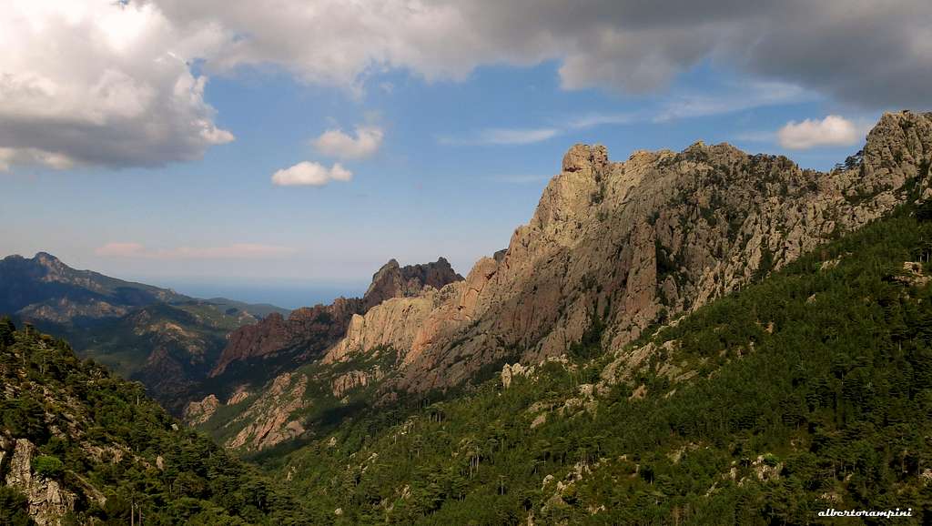
Tafunata di Paliri 1312 m
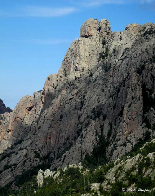
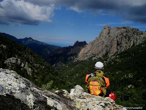
Tafunata di Paliri is a three-cuspidate complex summit situated in the Paliri Chain and delimitated by two saddles: Foce Finosella on its Northern side and Foce Finosa on its Southern side. It has two main faces right for climbing: the solemn and complex North-West Face and the sunny South-East face, which overlooks the small shelter of Paliri. These two faces are pierced by a big hole - close to the summit – which gives the name to the peak: as a matter of fact in the Corsican dialect “tafunata” means “hole”. On the sunny South-East face - a 250 m. high face – have been realized several climbing routes on excellent granite, nearby the fine milieu of the Paliri Hut, a bucolic and charmed place. Through this little shelter is transiting the GR 20, a long trail crossing the island from North-West to South-East. The most frequented and classic routes on this face are “Maravigliosa”, “Aventuriers de l’Entresol”, “Sari”, “Traversata S-N” and “Normal Route”.

|

|
The impressive North-West face is 500 mt. high, one of most high and severe in Bavella Massif; it dominates the San Petru stream and is well visible on the right of the road D268, when followed from Bavella to Solenzara. The most important routes on NW face are “Bettembourg Spur” and “Jean-Noel Roche Pillar”.
Tafunata di Paliri
Getting There

Access to the island
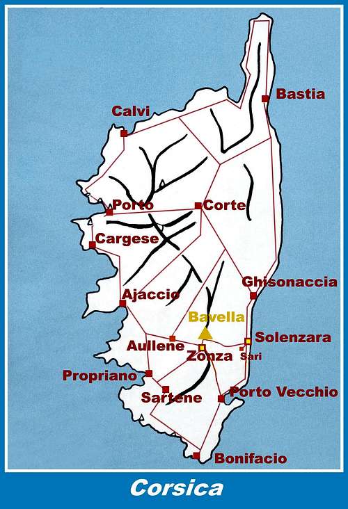
The island of Corse, l'Ile de Beauté (the Island of Beauty), politically belonging to France but much closer to Italy, can be approached by plane (airports in Bastia on the Eastern coast, Calvi and Ajaccio on the Western coast) and by ferry-boat from the French ports of Marseille, Nice, Toulon or from the Italian ports of Livorno, Genova and Savona. The most convenient destination in Corse to visit the Bavella area are the airports of Bastia on the Eastern coast (about 130 km. to Col de la Bavella) and Ajaccio (about 90 km. to Col de la Bavella) if you’re getting there by plane. The shortest way is from Livorno port on Italy Western coast to Bastia port on Corsica Eastern coast, if you’re getting there by ferry-boat.
The reference point to get to Tafunata di Paliri is Col de Bavella (Bavella Pass).
Road access to Col de Bavella
- From Bastia (Corsica Eastern coast) along RN 198 to Solenzara; less then 1 km. before Solenzara turn to right and follow D268 to Bavella Pass (km. 130 from Bastia)
- From Aiaccio (Corsica Western coast) along RN 196 to Petreto, then along N852 to Aullene, Quenza and Zonza (km. 90 from Aiaccio). From Zonza follow D268 to Col de Bavella
Admiring Tafunata |
Corsica Road map |
Walking approach to North-West Face From Col de Bavella descent along the road D268 towards Solenzara, reaching the “Arza Forestal House” (Maison Forestiere d’Arza). Parking. Just below the house follow on the right-hand side for about 20 minutes a forest road, crossing some stream over some causeways. After last crossing-stream (Riu San Petru) the forest road reachs the orographic right side of the valley. After 400 meters, a cairn marks on the right-hand side the path to Finosella Pass. Leve the forest road and follow this path, which crosses a dried stream, separating the Orgues de San Petru to the NW side of Tafunata. A few meters before the dried stream (cairn) leave the main trail (leading to Orgui d’u San Petru and Finosella Pass) and follow on the right an uncertain track marked by cairns, rising inside the forest. When the trail reachs an other stream, leave it, rising along a thick vegetation towards a great pillar. 50 mt. before reaching the base of the pillar , skirt towards right, heading to a rocky shoulder. Climb it towards the great corner where begins “Bettembourg Spur”.
Walking approach to Refuge de Paliri m. 1055 and South-East Face
From the Auberge – Gite d’Etape “du Col de Bavella”, situated 500 mt. to Bavella Pass along the NE side of the road D268, follow the forest road starting just behind the hut and joining the GR20 trail; the road descents to reach another forest road, crossing a stream. Follow it for a short distance (about 150 mt.), then turn to right following again the GR20. The trail rises across a “pino laricio” forest and reachs Finosa Pass mt. 1195; from here the trail goes down to the beautiful Paliri Hut m. 1055 (water, guarded in summer). From the hut a short track in five minutes leads to the South-East Face (2 hours from the “Gite d’Etape”).

|

|
Tafunata di Paliri routes overview
TAFUNATA DI PALIRI ROUTES OVERVIEW (from left to right)
SOUTH-EAST FACE
“Normal Route” PD, PD+ “ via ferrata” (equipped with iron chains) 200 m.
"Tatafoni” D not equipped
"Traversata SW-NE” D, 5b, 200 m
“Maravigliosa” + Classic route exit TD sup., 6b+, 6a obbl., 150 mt., bolts
“Aventuriers de l’Entresol” TD, 6c, A0, 6a obbl., 200 m, bolts
"U me amore" TD, 6a max, 270 m., trad climb
"Andaccianu” TD, 250 mt., trad climb
"Togna” TD, 250 m
“L’omu liberu” TD, 300 m Trad climb
"Sari” TD, 350 mt., Trad climb
“NE Ridge” AD

|

|
NORT-WEST FACE
“Krah Route” D, 400 m
“Bettembourg Spur” TD, 450 m Trad climb
"Grand Hotel ABO, 400, Engaging trad climb
"Le Bananier” TD, 150 m
“U Scoddu” TD, 400 m
"Jean Noel Roche Pillar" TD, 6a obbl., 400 m. Trad climb
"Foelsche Route” D
"SW Ridge” AD

Tafunata di Paliri Normal Route - Via Ferrata
Tafunata di Paliri Normal Route - Via Ferrata report
Summit altitude: m. 1305
Grade: PD to the hole, PD+ to the summit (South summit, the lower, m. 1305)
Climbing length: 270 m.
Exposure: South-East
Starting point: Refuge de Paliri m. 1055
The original smart route, pioneered by the Paliri shepherds, was equipped with iron chain by J. P. Quilici. The route is quite spectacular, crossing all the South-East Face from left to right and allowing the scramblers to get to the summit with low difficulties.

Tafunata and the hole seen from Punta Anima Dannata |
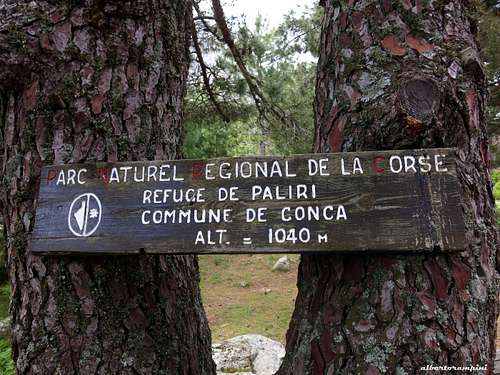
Parc Naturel de la Corse signpost |
From Paliri shelter follow the path heading to NW and rising on the wooden slopes below the SE face and reach the left sector of the face. After the first ridge, turn to right and climb a grassy gully stopped by some blocks in its upper part. Cross the blocks through a little tunnel, then follow the ledge rising slants to right and reaching the South-East crest. Head to left and climb a gully and an equipped chimney, reaching the "tafone" (hole) at 1250 m. of altitude. From the hole get back a bit to catch another chain and climb the ending gully to the South summit (1 hour from the shelter).
Descent: reversing the same route
Red Tape
Bavella Massif is really a fantastic world, a preserved milieu situated inside a Regional Park Parc Naturel Régional de Corse - Parcu di Corsica. Free camping and bivouac are not allowed. Fires are strictly forbidden. Maximum care is required to keep for the future this extraordinary environment.
Nature and climate
Nature is wild and peculiar; in Corsica we can find more than 5% of authoctonous kinds of flower and plants, in addition to the authoctonous fauna. On the contrary, several kinds of animal current inside Mediterranean countries are away from Corsica, like squirrels and vipers.

|

|
Climate is the typical one of the mediterranean middle-mountain areas situated at these latitudes: often very hot in summer and with cold and snowy winters; early and middle Spring and early Fall are the better seasons to climb. Due to Bavella closeness to the sea, winds are often stronger how much they are at the same height in the Alps. Rainfall sometimes are important and dangerous when joined with strong winds. On the contrary, sometimes we can find some long periods of drought.

Where to stay
- REFUGE PALIRI - COL DE BAVELLA - Auberge du Col de Bavella – Hotel and Gite d’Etape AUBERGE DU COL DE BAVELLA
- Les Aiguilles de Bavella – Gite d’Etape GITE D'ETAPE LES AIGUILLES DE BAVELLA

|

|

|
- ZONZA
– Hotel L’Aiglon, Hotel de la Terrasse - Municipal Camping of Zonza, Camping La Riviere
When to climb and hike
On the sunny SE face is possible to climb almost all year round, in the absence of snow. Anyhow, the best season to climb goes from April to the end of October.
Meteo
Guidebooks and maps
 |
 |
 |
 |
- Guidebooks
“Bavedda – Aiguilles entre ciel et torrents: Escalade, Rando, Canyon” by Jean Louis Fenouil and Jean Paul Quilici - FFME
“Guide d’escalade en Corse” Vol. I Massif de Bavella by Jean Paul Quilici – Bernard Vaucher
“Rocca è Sole” Massif de Bavedda by Jean Paul Quilici – Francis Thibaudeau
"Corse L'ile verticale" by Martail Lacroix - Pierre Sanchou
- Maps
IGN 4253 ET “Aiguilles de Bavella – Solenzara”