
-
 6426 Hits
-
 86.85% Score
-
 23 Votes
|
|
Mountain/Rock |
|---|---|
|
|
41.83219°N / 9.26018°E |
|
|
Bavella, Bavedda |
|
|
Trad Climbing, Sport Climbing |
|
|
Spring, Summer, Fall |
|
|
3825 ft / 1166 m |
|
|
Overview
Geographical classification: Corsica - Corse > Bavella Massif > Punta di U Chiapponu
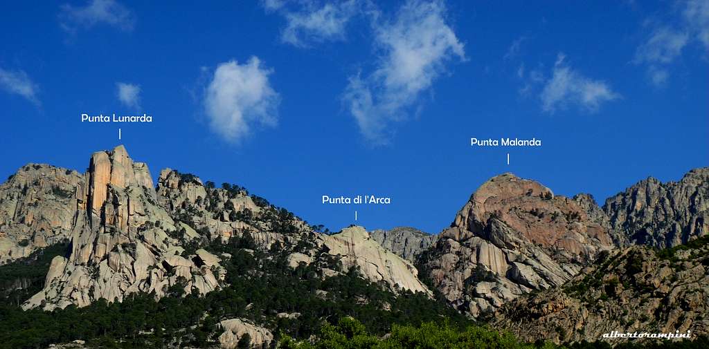
Punta Malanda 1166 m
Though not as spectacular as Punta Lunarda and Teghie Lisce, Punta Malanda is another granite jewel located in the Bavella Massif. Compared to these more famous walls it is also located in a little more secluded position inside the Purcaraccia Canyon. With its magnificent reddish SE face, the lonely dome of Punta Malanda is located to the West of Bocca di Larone, overlooking the great and complex canyon named Purcaraccia. Its roundish shapes quite clash with the slender steepness of the nearby Punta Lunarda.


On the shady and hidden North face, there are a couple of high difficulty routes. Also in reason of its rather long approach, to climb this peak will give you a wild experience; and in reason of its secluded situation its faces had waited until the beginning of the XXI century to be climbed. Just the Normal route, easy but with a certain interest, had been climbed before.
Getting There
The majestic entrance within Bavella group is the Bavella Pass m. 1211.

ROAD ITINERARIES TO BAVELLA PASS
From BASTIA (Corsica Eastern coast) take RN 198 towards Solenzara; a few kilometers before getting there, turn to right following D268 to Bavella Pass (km. 130 from Bastia).
From AIACCIO (Corsica Western coast) follow the road RN 196 to Petreto, then the road N852 to Aullene, Quenza and Zonza (km. 90 from Aiaccio).
From Bavella Pass mt. 1211 descent along North East side of the road D268, reaching a pass named Bocca di Larone mt. 608. Parking. From Bocca di Larone parking get back a bit along D268 to reach on the West side of the pass the first great hairpin.
Punta Malanda routes overview
Punta Malanda routes overview (French scale)
South-East Face
- Sisyphe ou "L’Envolèe Granitique" TD+, 6b+ max., 6a obbl., 270 m.- equipped with bolts
- La Fille d'Avril TD+, 6c max., 6a+ obbl., 290 m. - equipped with bolts - This route is located to the left of Sisyphe, with similar difficulty, but better protected.
- Gaia TD+, 6b max., 6b obbl., 270 m. - trad route


North Face
- Voie de la Face Nord ABO, 7c max., 6c obbl., 200 m. - equipped with bolts
- Sintomi strani ABO inf., 7c max, 7a obbl., 250 m- Partially equipped - David Bacci and Matteo Della Bordella, april 2012
Sisyphe ou L'Envolee Granitique
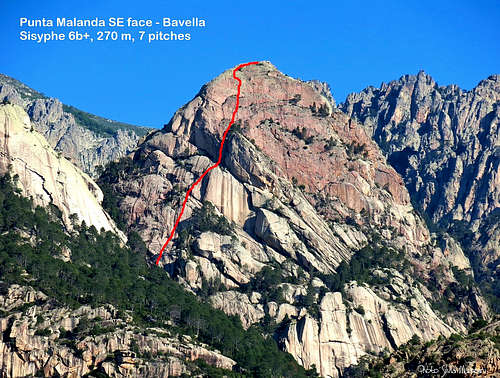
Sisyphe ou L'Envolee Granitique report
Difficulty: TD sup., F6b+, F6a obbl.
Summit altitude: mt. 1166
Length: 270 mt. Pitches: 7
Exposure: SE
First ascent: D. Allemand – L. Menetrier 2000
Starting: Bocca di Larone m. 608 - Road D268 Col de Bavella
A technical superb route on extra-solid red granite. Equipped with bolts.
Approach: when driving from Solenzara to Col de la Bavella along the road D268, beyond the Bocca di Larone you will get to a great hairpin. From here it starts on the right a mainly level track, entering a dense vegetation and skirting on the right the great canyon of the Purcaraccia. After half an hour the track goes down to reach the stream. Cross it gaining the opposite bank, return to the valley for 50 meters and take a secondary path rising along the steep wooded slope along a not very obvious trail, but marked with several cairns. After 15 minutes the trail goes towards left (South) along some slopes, to enter a great vegetated and stony gully. Climb the gully following the cairns. the starting point of Sisyphe is situated in the upper and right part of the gully (1 hour and 30 minutes from Bocca di Larone).
Sisyphe report (French Scale)
P1 - Climb a technical smooth and sloping slab 6b+
P2 - Follow another technical slab a bit easier 6a+
P3 - Another slab and dihedral 5b
P4 - Head slantaway towards right. Now the climb becomes steeper. A crux move, then a fine climb on a dihedral and a reddish wall. 6a
P5 - A difficult and steep wall with some athletic moves. Spaced bolts. 6b
P6 - Another steep wall a bit easier. Spaced bolts. 6a
P7 - An easy pitchs leads on the superb summit. A majestic view over Bavella stone’s world.


Descent: abseiling. After the first three abseils on the line of the route, traverse left (facing in) reaching a vegetated ledge. From here an abseil reachs the route’s second belay. Another abseil leads to the bottom.
Red Tape

|

|
Bavella Massif is a wild group situated inside a Regional Park. Free camping and bivouac are not allowed. Fires are strictly forbidden. Maximum care is required to preserve this extraordinary environment.
Punta Malanda Via Normale
Punta Malanda Normal route is a pleasant itinerary to get the summit with little difficulty in a wonderful environment. Rope is useful for the less experienced climbers.
Route description - Follow the trail starting in the first hairpin of the road under the Bocca di Larone as described in the previous route, but continue on the right bank of the Purcaraccia (in the direction of the walk, left orographic) up the magnificent stream (cairns) up to the altitude of 779 m. Continue right bank (left orographic) for 200 m, cross the stream, and follow the left bank for 200 m again. Climb up in the SW direction on a bed of dry torrent (cairns), to the W of the N face of Punta di Malanda, until Bocca Malandata (not named on the IGN map). From there, take the SW ridge with a few steps from II and III not exposed) to the summit.
Descent: reversing the same route
Nature and climate


Nature is wild and peculiar; in Corsica we can find more than 5% of authoctonous kinds of flower and plants, in addition to authoctonous fauna. On the contrary, several kinds of animal current inside Mediterranean countries are away from Corsica, like squirrels and vipers.
Climate is the typical one of the mediterranean middle-mountain areas situated at these latitudes: often very hot in summer and with cold and snowy winters; early and middle Spring and early Fall are the better seasons to climb. Due to Bavella closeness to the sea, winds are often stronger how much they are at the same height in the Alps. Rainfall sometimes are important and dangerous when joined with strong winds. On the contrary, sometimes we can find some long periods of drought.

When to climb and hike
Best seasons are Spring and Fall.
Where to stay

COL DE BAVELLA
- Auberge du Col de Bavella – Hotel and Gite d’Etape
- Les Aiguilles de Bavella – Gite d’Etape GITE D'ETAPE LES AIGUILLES DE BAVELLA
ZONZA
– Hotel L’Aiglon, Hotel de la Terrasse - Municipal Camping of Zonza, Camping La Riviere
Meteo
Guidebooks and maps
 Climbing, hiking and Canyoning Guidebook")


Guidebooks
“Bavedda – Aiguilles entre ciel et torrents: Escalade, Rando, Canyon” by Jean Louis Fenouil and Jean Paul Quilici - FFME
“Guide d’escalade en Corse” Vol. I Massif de Bavella Jean Paul Quilici – Bernard Vaucher
“Rocca è Sole” Massif de Bavedda Jean Paul Quilici – Francis Thibaudeau
Maps
IGN 4253 ET “Aiguilles de Bavella - Solenzara