
-
 3895 Hits
-
 83.1% Score
-
 16 Votes
|
|
Mountain/Rock |
|---|---|
|
|
46.70623°N / 11.50080°E |
|
|
Hiking, Scrambling |
|
|
Summer, Fall, Winter |
|
|
8117 ft / 2474 m |
|
|
Overview
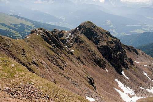 Ritzlarspitze seen from Kassianspitze Ritzlarspitze seen from Kassianspitze |
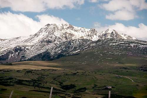
Ritzlarspitze - in Italian simply called Ritzlar - is one of the three summits which make up a small cirque of mountains in the east of the Sarntal Alps / Monti Sarentini. The highest of the three is Kassianspitze / Cima San Cassiano, the second highest Samspitze and Ritzlarspitze comes in at number three. The cirque is open to the south and Ritzlarspitze with its two ridges makes up the eastern part of it.
Right underneath our mountain you can find the pilgrimage chapel and rustic restaurant of Latzfonser Kreuz /San Croce di Lazfons, the highest pilgrimage sanctuary of Südtirol / Alto Adige. Two pilgrimage trails head for the site, one from Latzfons in Eisacktal / Valle d'Isarco, the other from Reinswald / San Martino in Sarntal / Val Sarentino. As access routes these trails are long and cover lots of elevation gain but still they remain quite easy, which makes Latzfonser Kreuz a very popular place among hikers of all sorts.
 Rosengarten / Catinaccio Rosengarten / Catinaccio | ||
 Pfunderer Berge Pfunderer Berge |  Rötspitze Rötspitze |  Hochferner and Hochfeiler Hochferner and Hochfeiler |
 Wilde Kreuzspitze Wilde Kreuzspitze | 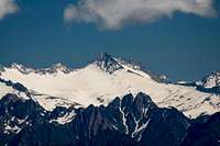 Turnerkamp Turnerkamp | 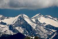 Hoher Weißzint and Großer Möseler Hoher Weißzint and Großer Möseler |
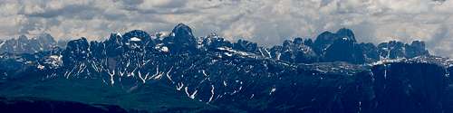
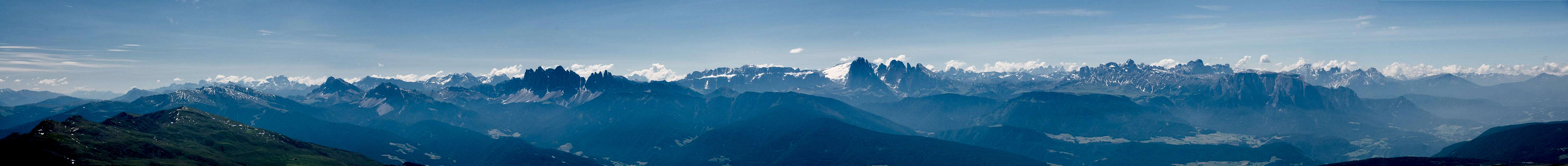
In consequence the three mountains to the north of the pilgrimage chapel get quite a lot of visitors each day. Most of thos visit concentrate on Kassianspitze / Cima San Cassiano, so that the other two often remain quite solitary. Still, all three mountains offer exceptional views mostly to the east, where the western Dolomites can be seen and Ritzlarspitze is no exception. Also, the glaciated summits of the Zillertal Alps Mmain Ridge are on display. Eastern and northern views, however, are obstructed by the neighbouring two mountains.
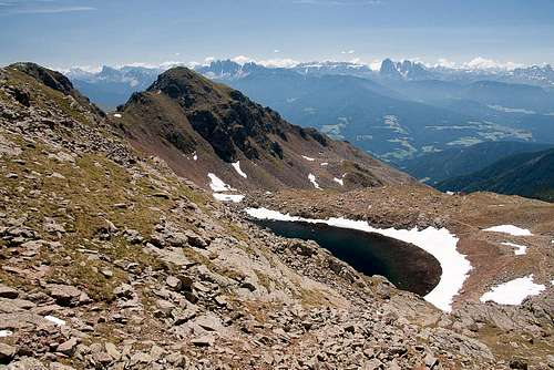
There are two routes to the mountain, one a hard scramble from Latzfonser Kreuz across its south ridge. The slope is very steep and brittle and in many places the path is worn down to invisibility. The second route comes down from Kassianspitze across the ridge which connects the two mountains. This hike is easy though the final part is somewhat exposed. Of course, a climb of Ritzlarspitze can be combined with both the other mountains and is a 2 - 3h round trip from Latzfonser Kreuz.
The Dolomites Panorama
  |
Getting There
 Kassianspitze and Ritzlarspitze
There are two reasonable trailheads for Ritzlarspitze, one at Reinswald / San Martino in Sarntal / Val Sarentino (or rather Durnholztal / Valdurna) and Lazfons in Eisacktal / Valle Isarco. Both trailheads are connected by the pilgrimage trail to the sanctuary at Lazfonser Kreuz / S. Croce di Lazfons
- Reinswald / San Martino trailhead
- Take Brenner Motorway A22 to Bozen / Bolzano
- Drive through the city, following signs to Sarntal / Val Sarentino on SS508
- At Astfeld / Campolasta turn off onto SP137, direction Durnholz / Valdurna
- At Unterreinswald / San Martino Bassa turn onto SP138 to Reinswald / San Martino. Park at the cable-car station.
- Lazfons trailhead
- Take Brenner motorway A22 to the exit Klausen / Chiusa.
- Take SP74 to Feldthurns / Velturno
- Turn left onto SP142 to Lazfons
Red Tape
 Ritzlarspitze
There's no red tape. You might have to cross pasture gates which you are requested to shut behind you.
Accommodation
Eisacktal / Valle Isarco
Bozen / Bolzano
Weather Conditions
Maps & Books
Maps
- Digital Maps
- Regular Maps
- Sarntal/Val Sarentino
Kompass Map WK 056
1:35.000
ISBN: 3-85491-340-0
- Brixen / Bressanone
Kompass Map WK 56
1:50.000
ISBN: 3-85491-063-0
- Bozen / Bolzano
Kompass Map WK 54
1:50.000
ISBN: 3-85491-061-4
- BOLZANO-RENON / BOZEN-RITTEN-TSCHÖGGLBERG
Tabacco Map 034
1:25.000
- MONTE SARENTINI / SARNTALER ALPEN
Tabacco Map 040
1:25.000
- Sarntal/Val Sarentino
Books
- Bozen-Salten-Schlern
Kompass Guidebook WF953
Kompass Verlag
ISBN: 3-85491-406-7
- Rund um Bozen
Helmut Dumler
Rother Verlag
ISBN: 3-7633-4267-2