
-
 7994 Hits
-
 85.36% Score
-
 20 Votes
|
|
Mountain/Rock |
|---|---|
|
|
46.80864°N / 11.48277°E |
|
|
Hiking |
|
|
Spring, Summer, Fall, Winter |
|
|
8287 ft / 2526 m |
|
|
Overview
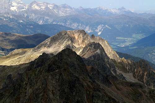 Sulzspitze (front) and Tatschspitze (in the sun) as seen from Tagewaldhorn Sulzspitze (front) and Tatschspitze (in the sun) as seen from Tagewaldhorn |
Penser Joch / Passo di Pennes in the Sarntal Alps is overlooked by several easy and some not-so-easy summits. Tatschspitze / Montaccio di Pennes belongs to the former category, though when seen during the approach to the pass it looks formidable enough. Its east face - like so many east-faces on the eastern side of the Sarntal Alps - is steep, almost vertical scree with several towers rising out of the rubble. The western side, however is a smooth broad slope which can be climbed easily from neighbouring Niederjoch / Dosso Basso.
The proximity to Penser Joch makes Tatschspitze a moderately popular destination in the otherwise often overlooked Sarntal Alps. It is but a short hike from the main trekking trail of the range, the "Sarntaler Hufeisentour" (= Sarntal Horseshoe Trail, named for the shape of the mountain range) and thus is often climbed just before finishing the stage, which ends at Penser Joch. Also, the location of the mountain makes it a very good lookout peak, with views ranging far across the surrounding mountain ranges towards the mountains of the Brenta and Presanella Groups in the south-west, the Dolomites in the south-east or towards the Hohe Tauern Range in the east.
Still, the summit won't be exactly crowded. The crowds are deflected to the far more popular Sarner Weißhorn / Corno Bianco Sarentino or Zinseler / Cima di Stilves, one because of the ferrata through its south-east slopes, the other because of its easy accessibility. The hike to Tatschspitze avoids Niederjoch but joins the exposed ridge between the two mountains. It reaches a small saddle, in which the ascent trail to Tatschspitze leaves the trekking tail. The remainder is a moderately steep hike along a marked trail across the west slopes of the mountain.
|


Faraway views
HaunoldDreischustersp.DürrensteinZwölferMonte SellaDrei ZinnenSeekofelHohe GaisslCristalloNeunerZehnerPlosePeitlerkofelTofaneLa VarellaCunturinesAferer GeislerGeisler / Odle GroupCivettaPiz BoèSella GroupMarmoladaGran VernelLangkofel GroupPale di San MartinoCima BocchePuflatschRosengarten GroupSchlernLatemar Group 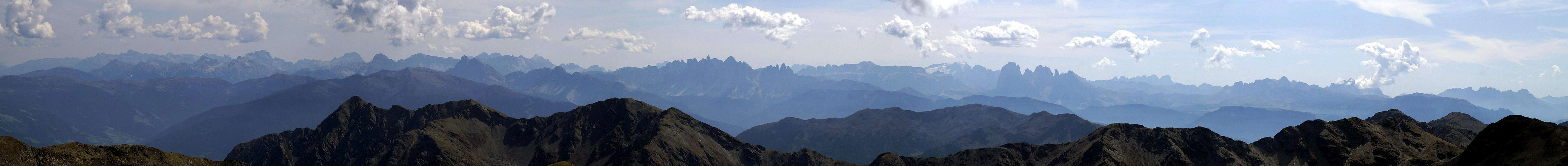  |
There's barely a mountain like Tatschspitze, which is better suited to take deep glimpses into the surrounding mountain regiuons. Some of the mountains, pictured in the thumbs are more than 60km away...
|


Getting There
Tatschspitze / Montaccio di Pennes Sulzspitze / Cima SulzTagewaldhorn / Corno di TraminNebelseespitze / Cima NebbiaHohe ScheibenPaulswand / Croda di Paolo 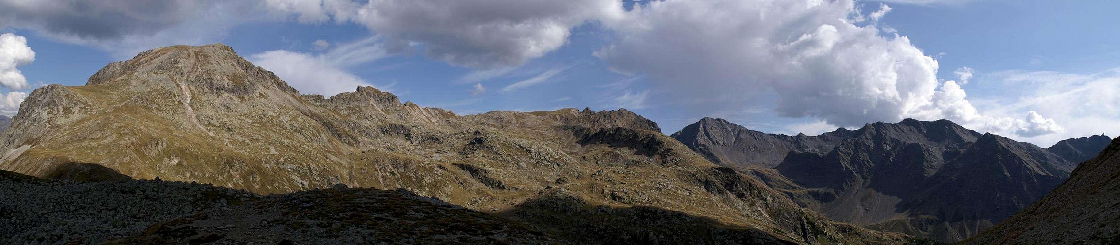 |
The mountain can be easily reached from the Brenner Motorway A22. Take the exit Sterzing / Vipiteno and follow the signs for SS508 in direction Penser Joch / Passo di Pennes.
There also is the possibility to start from Grasstein / Le Cave. Leave the motorway at Sterzing / Vipiteno and head for the highway SS12 heading south to Brixen / Bressanone. At Grasstein / Le Cave leave the highway and drive through the village. Approximately 200m after the last houses the road is closed. Here you can find a small parking lot with signs leading to Puntleider See (marked #14). From the lake trail 14c leads to Tatschspitze
Red Tape
 Mountain idyll at the base of Tatschspitze
There is no red tape in the Sarntal Alps. The areas close to Penser Joch is used for extensive cattle grazing - there are several farm buildings there and gates must be closed. Closer to Tatschspitze you only wind sheep and goats freely ranging around.
Accommodation
Rooms and Apartments
Eisacktal / Valle Isarco
Passeiertal / Val Passiria
Camping
- The closest campground is at Gasteig / Casateia in Ratschingstal / Valle di Racines to the north of the mountain. The campground is called "Gilfenklamm" and is located on SS44 to Jaufenpass / Passo del Giovo.
Huts
- There are no real huts close by but you can use the hotel/restaurant at Penser Joch / Passo di Pennes. Also in Pens / Pennes to the south of the mountain several inns can be found.
Weather Conditions
Maps And Books
Maps
- Digital Maps
- Regular Maps
- Sarntal/Val Sarentino
Kompass Map WK 056
1:35.000
ISBN: 3-85491-340-0
- Sterzing / Vipiteno
Kompass Map WK 44
1:50.000
ISBN: 3-85491-050-9
- Brixen / Bressanone
Kompass Map WK 56
1:50.000
ISBN: 3-85491-063-0
- MONTE SARENTINI / SARNTALER ALPEN
Tabacco Map 040
1:25.000
- Sarntal/Val Sarentino
Books
- Rund um Sterzing
Henriette Klier / Walter Klier
Rother Verlag
ISBN: 3-7633-4167-6
- Rund um Meran
Henriette Klier
Rother Verlag
ISBN: 3-7633-4290-7