
-
 7444 Hits
-
 83.1% Score
-
 16 Votes
|
|
Mountain/Rock |
|---|---|
|
|
46.78043°N / 11.49702°E |
|
|
Hiking, Mountaineering, Scrambling |
|
|
Summer, Fall |
|
|
8885 ft / 2708 m |
|
|
Overview
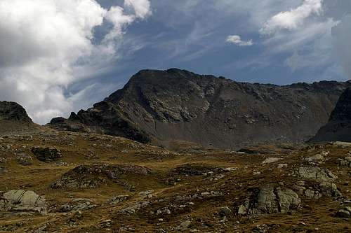 Tagewaldhorn / Corno di Tramin north face Tagewaldhorn / Corno di Tramin north face |
The horseshoe shaped range of Sarntal Alps in the north of Italy is a lonesome mountain range though it is located between several of the major north-south traffic routes through the Alps. Nowhere is this solitude more obvious than in the central part of the Tramin Group, in the north-eastern section of the horseshoe. In that subrange only two mountains surmount the elevation of 2700m - Jakobsspitze / Cima San Giacomo (2742m) and Tagewalldhorn / Corno di Tramin (2708m). Both are located close to the main trecking trail through the Sarntal Alps, the Sarner Hufeisentour (Sarntal Horseshoe Trail). Both mountains are located close to each other with Tagewaldhorn in the north, Jakobbsspitze in the south. Also, both mountains are very remote.
In order to reach Tagewaldhorn you have to scale at least 1200m in elevation difference. The most sensible approach appears to be the one from the Penser Joch / Passo di Pennes Road Pass. While this trailhead is already located at 2211m the trail itself passes several ridges and thus with all the ups and downs you have to climb about 800m in elevation before you reach the base of the mountain. Other trailheads are at Grasstein / Le Cave in Eisacktal Valley / Valle Isarco or Asten / Laste in Pensertal valley / Valle di Pennes but their respective elevations are 1000m and 1300m. All three routes combine at Traminscharte / Giogo di Tramin, right underneath the steep north ridge of the mountain.
 |  |  |
This north ridge is a scary, scree covered knife edge of a ridge, dropping off about 300m to the east. To the west of this ridge there is a steep scree couloir, which can be used as an ascent route if the ridge itself seems too dangerous. Unfortunately the rock quality of Tagewaldhorn - like the one of all other Sarntal Alps summits - is rather poor and this is most evident when you climb the mountain from its northern side. Not very attractive, but in hindsight one of the major attractions of the mountain.
 Looking east from Flaggerscharte. Tagewaldhorn to the left
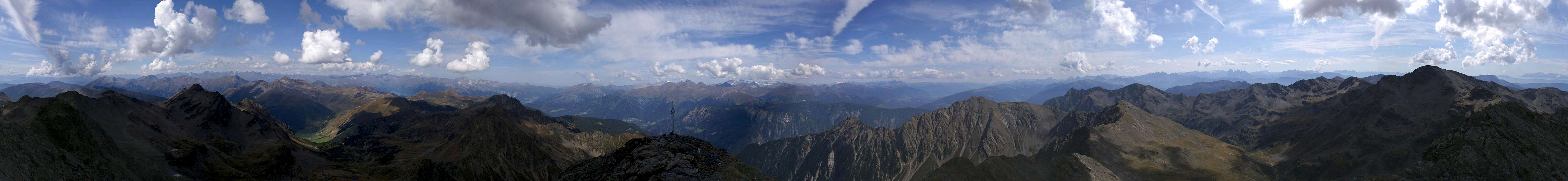
The other attraction quite naturally is the view you have from its summit. Since the mountain is located in the north-east of the Sarntal Alps and since there is only one higher mountain in the vicinity it offers perfect views of all ranges around. Beside the peep into the Sarntal Horseshoe itself the Stubai and Zillertal Alps can be seen as well as the western Dolomites. In the far distance you can get glimpses of the Hohe Tauern Group in the east and the Ortler / Cevedale Group in the west.
The summit Panorama
  |
Getting There
 The Zillertal Alps as seen during the approach to Tagewaldhorn
The mountain can be easily reached from the Brenner Motorway A22. Take the exit Sterzing / Vipiteno and follow the signs for SS508 in direction Penser Joch / Passo di Pennes.
The second trailhead ad Asten / Laste can be reached from Penser Joch by taking SS508 further onwards until you reach Pens / Pennes. There turn onto the side road to Asten / Laste.
There also is the possibility to start from Grasstein / Le Cave. Leave the motorway at Sterzing / Vipiteno and head for the highway SS12 heading south to Brixen / Bressanone. At Grasstein / Le Cave leave the highway and drive through the village. Approximately 200m after the last houses the road is closed. Here you can find a small parking lot with signs leading to Puntleider See (marked #14). From the trail leads to on to Tagewaldhorn.
Red Tape
 The eastern Durnwald Ridge as seen from Tagewaldhorn
There is no red tape in the Sarntal Alps. The areas close to Penser Joch is used for extensive cattle grazing - there are several farm buildings there and gates must be closed. Closer to Tagewaldhorn you only find sheep and goats freely ranging around.
Accommodation
Rooms and Apartments
Camping
- The closest campground is at Gasteig / Casateia in Ratschingstal / Valle di Racines to the north of the mountain. The campground is called "Gilfenklamm" and is located on SS44 to Jaufenpass / Passo del Giovo.
Huts
- There are no real huts close by but you can use the hotel/restaurant at Penser Joch / Passo di Pennes. Also in Pens / Pennes to the south of the mountain several inns can be found.
Weather Conditions
Maps And Books
Maps
- Digital Maps
- Regular Maps
- Sarntal/Val Sarentino
Kompass Map WK 056
1:35.000
ISBN: 3-85491-340-0
- Sterzing / Vipiteno
Kompass Map WK 44
1:50.000
ISBN: 3-85491-050-9
- Brixen / Bressanone
Kompass Map WK 56
1:50.000
ISBN: 3-85491-063-0
- MONTE SARENTINI / SARNTALER ALPEN
Tabacco Map 040
1:25.000
- Sarntal/Val Sarentino
Books
- Rund um Sterzing
Henriette Klier / Walter Klier
Rother Verlag
ISBN: 3-7633-4167-6
- Rund um Meran
Henriette Klier
Rother Verlag
ISBN: 3-7633-4290-7
visentin - Aug 9, 2010 2:50 am - Voted 10/10
little bugthe pictures in the 2nd row just after "underneath the steep north ridge of the mountain." appear like over each other. Looks like a bug in the code to display them in a row. otherwise nice page again !
Gangolf Haub - Aug 9, 2010 4:01 am - Hasn't voted
Re: little bugHmmm - the code is ok but I think we are having issues with rackspacecloud again, the hoster, which hosts all SP pictures. SP is almost crawling at standstill speed ... Rather a big bug ...