
-
 6565 Hits
-
 83.69% Score
-
 17 Votes
|
|
Mountain/Rock |
|---|---|
|
|
46.79089°N / 11.49067°E |
|
|
Hiking, Scrambling |
|
|
Summer, Fall, Winter |
|
|
8438 ft / 2572 m |
|
|
Overview
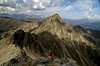
 Sulzspitze / Cima Sulz seen from the Tagewaldhorn north ridge Sulzspitze / Cima Sulz seen from the Tagewaldhorn north ridge |
Sulzspitze is one of the summits located in the Tramin Group in the north-east of the Sarntal Alps / Monti Sarentini. Its bases can be easily reached, either from Penser Joch / Passo di Pennes or from Grasstein / Le Cave in the Eisacktal Valley, Valle Isarco. The summit, however, is a different affair. The only way to reach it is the mountain's north-eastern ridge, a chossy slope which ends in an exposed crest, leading to the top. In the end you are awarded great views of the surrounding alpine groups, most significantly the Stubai Alps, Zillertal Alps and Western Dolomites.
Sulzspitze is rarely climbed, mainly because the huge elevation gain of 1500m on its normal route. Also, the easier summit of Tatschspitze / Montaccio di Pennes is located directly to the north and the similarily precarious Tagewaldhorn / Corno di Tramin can be found directly to its south. The route is often very exposed which - together with the chossy quality of the crest makes the climb rather uncomfortable. On the other hand, the summit itself is very beautiful to behold, especially when seen from Tagewaldhorn or from Traminscharte. From this side (south) it looks like a fine cone shaped pyramid.
The first part of this normal route is a well used hiking trail, from Grasstein Le Cave in Eisacktal Valley / Valle Isarco to the east. It leads to Puntleider See, where two trails lead to the two neighbours, Tatschspitze and Tagewaldhorn. The Sulzspitze ascent heads up right in the middle, evading the summit of Schönjoch / Giogo Bello. It is marked by cairns but sparsely. The maps, listed below don't show this route though the map in the guidebook (also listed below) does.
In winter Sulzspitze is the destination of a ski tour from Penser Tal / Valle di Pennes, that is from the western side of the mountain.
|


Summit views
 Nebelseespitze
Sulzspitze is a great lookout summit though my pictures don't really show it due to the weather:-(
|


Getting There
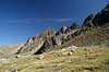
 Sulzspitze / Cima Sulz as seen from Niedereck / Dosso Basso
Sulzspitze / Cima di Sulz can be easily reached from the Brenner Motorway A22. Leave it at Sterzing / Vipiteno and head for the highway SS12 heading south to Brixen / Bressanone. At Grasstein / Le Cave leave the highway and drive through the village. Approximately 200m after the last houses the road is closed. Here you can find a small parking lot with signs leading to Puntleider See (marked #14).
Red Tape
 Sulzspitze / Cima Sulz as seen from the west
Accommodation
See the following links for rooms and apartmentsWeather Conditions
Maps & Books
Maps
- Digital Maps
- Regular Maps
- Sarntal/Val Sarentino
Kompass Map WK 056
1:35.000
ISBN: 3-85491-340-0
- Sterzing / Vipiteno
Kompass Map WK 44
1:50.000
ISBN: 3-85491-050-9
- Brixen / Bressanone
Kompass Map WK 56
1:50.000
ISBN: 3-85491-063-0
- MONTE SARENTINI / SARNTALER ALPEN
Tabacco Map 040
1:25.000
- Sarntal/Val Sarentino
Books
- Rund um Sterzing
Henriette Klier / Walter Klier
Rother Verlag
ISBN: 3-7633-4167-6
- Rund um Meran
Henriette Klier
Rother Verlag
ISBN: 3-7633-4290-7