
-
 8142 Hits
-
 85.36% Score
-
 20 Votes
|
|
Mountain/Rock |
|---|---|
|
|
46.84070°N / 11.44295°E |
|
|
Hiking |
|
|
Spring, Summer, Fall, Winter |
|
|
7946 ft / 2422 m |
|
|
Overview
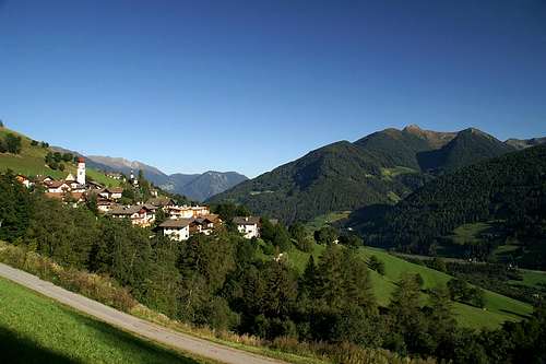 The village of Telfes and Zinseler / Cima di Stilves The village of Telfes and Zinseler / Cima di Stilves |
Zinseler / Cima di Stilves is another one of the cornerstone mountaiins rising directly out of the Sterzing / Vipiteno Basin. Like Roßkopf / Monte Cavallo and Mareiter Stein / Sasso di Mareta which terminate the two southernmost Stubai Alps ridges and Saun, which terminates the Tux Main Ridge of the Zillertal Alps Zinseler is the last of the mountains of the north-eastern Sarntal Alps. Like its brethren on the other sides of the valley it rises for more than 1000m (in fact for about 1500m) out of the broad basin itself.
As a climbing objective Zinseler is an easy destination, as it is located very close to the Penser Joch Saddle / Passo di Pennes and can be reached in slightly more than one hour. Therefore it can be (and often is) combined with Sarner Weißhorn / Corno Bianco Sarentino on the other side of the saddle. Between the two mountains lie three more summits, Hühnerspiel / Cima Specola, Ganskragenspitze / Punta di Campo and Röthenspitze / Punta Roossa so that you can bag five summits with just 800m - 900m elevation gain.
A very interesting alternative is to climb the mountain from Sterzing / Vipiteno itself. After jogging up a mountain dirt roadyou reach the Zinseler North ridge just above the timberline, where you can bag an additional summit, Mandlseitejoch / Monte Mandola. The traverse between the two summits is quite exposed and already offers great views all around.
Zinser also is a popular ski tour destination in winter, mostly climbed through the Gospeneid Valley / Valle di Caspineto. The photographic results of one such tour can be admired in the next section.
|


Summit Panorama
RinnerspitzeSprinzenwandSchneeb. WeißenBotzerHochgewändSonklarsp.ZuckerhütlWilder PfaffBecherWilder FreigerRuderhofsp.Agglssp.Westl. FeuersteinÖstl. FeuersteinLorenzsp.HocheckSchneesp.Maurersp.Wettersp.Schafkampsp.Telfer WeißenWeißwandHoher ZahnPlerscher PingglGoldkapplRoßkopfPflerscher TribulaunGschnitzer TribulaunSchwarze WandNördl. RoßlaufSüdl. RoßlaufKirchdachGrubenkopfKesselspitzeGeierskragen SerlesHoher Lorenzen 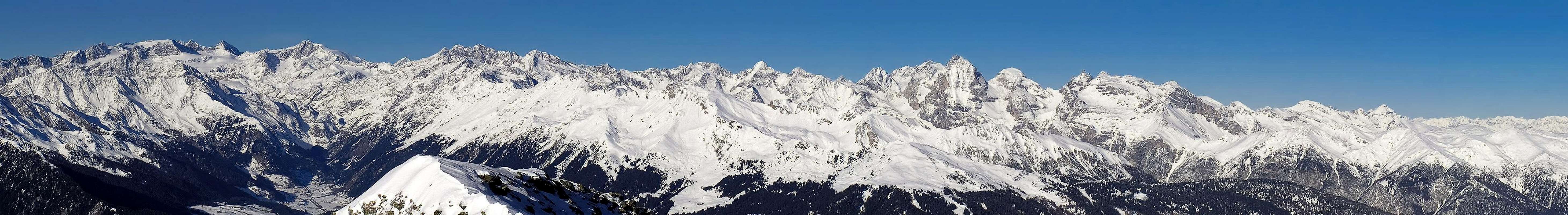  |
Getting There
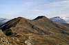
 Hühnerspiel and Zinseler in front of the Tribulaun Group
The mountain can be easily reached from the Brenner Motorway A22. Take the exit Sterzing / Vipiteno and follow the signs for SS508 in direction Penser Joch / Passo di Pennes.
For the tour along the north ridge leave SS508 right at its beginning (at the motorway toll station and drive up a narrow mountain road to the hamlet Gupp.Park at the bar and take the road further on upwards. It ends at the timberline where the ridge traverse starts.
Red Tape
There is no red tape here except for the camping regulations. You are not allowed to freely camp anywhere except in the official campgrounds. There is one quite close at the northern base of the mountain at Gastein / Casatteia. Another possibility is to camp in the vicinity of the toll station of the Brenner Motorway.Accommodation
Rooms and Apartments
Eisacktal / Valle Isarco
Passeiertal / Val Passiria
Camping
- The closest campground is at Gasteig / Casateia in Ratschingstal / Valle di Racines to the north of the mountain. The campground is called "Gilfenklamm" and is located on SS44 to Jaufenpass / Passo del Giovo.
Huts
- There are no real huts close by but you can use the hotel/restaurant at Penser Joch / Passo di Pennes. Also in Pens / Pennes to the south of the mountain several inns can be found.
Weather Conditions
 |
Maps & Books
Maps
- Digital Maps
- Regular Maps
- Sarntal/Val Sarentino
Kompass Map WK 056
1:35.000
ISBN: 3-85491-340-0
- Sterzing / Vipiteno
Kompass Map WK 44
1:50.000
ISBN: 3-85491-050-9
- Brixen / Bressanone
Kompass Map WK 56
1:50.000
ISBN: 3-85491-063-0
- MONTE SARENTINI / SARNTALER ALPEN
Tabacco Map 040
1:25.000
- VIPITENO-ALPI BREONIE / STERZING - STUBAIER ALPEN
Tabacco Map 038
1:25.000
- Sarntal/Val Sarentino
Books
- Meran-Burggrafenamt
Franziska Baumann
Kompass Guidebook WF951
Kompass Verlag
ISBN: 3-85491-386-9
- Rund um Sterzing
Henriette Klier / Walter Klier
Rother Verlag
ISBN: 3-7633-4167-6
- Rund um Meran
Henriette Klier
Rother Verlag
ISBN: 3-7633-4290-7