Summit dedicated on Monsignor Joseph Auguste Duc, prelate, historian and mountaineering between XIX° and XX° centuries. Easier to climb than it appears from an analysis from below and, for this reason, not very popular. Good view of the Mont Morion and to Chardoney-Becca Rayette-Monte Cervo Group.
Punta dedicata a Monsignor Joseph Auguste Duc, prelato, storico e alpinista tra il XIX° ed il XX° secolo. Più facile da salire di quanto non appaia da un'analisi dal basso e, proprio per questo, non molto frequentata. Buona vista sulla Catena del Mont Morion e sul Gruppo delle Chardoney, Becca Rayette e Monte Cervo.
First Ascents
First on the summit: Abbot Joseph Maria Henry and mountain's guide Théodule Forclaz, (Aug 04th, 1913).
First in winter: Giovanni Monaco and Lucio Monaco, (Feb 02th, 1964).
SW Slope: Ivo Gerbaz, solo (Jul 1967).
SE Arête (integral): Renato Chabod and C. Sapegno, (Sep 20th, 1926).
NW Ridge: Renato Chabod, Amilcare Crétier and Giuseppe Riconda, (Jul 04th, 1926), in descent.
NE Face: Giovanni Pezzoli and Cesare Quey, mountain carriers, (Aug 18th, 1947).
SE Arête and E slope: Giovanni Pezzoli and Cesare Quey, mountain carriers, (Aug 18th, 1947), in descent.
Getting There
BY CAR:
From Torino, Milano, etc: Motorway A5. Exit at Aosta Est.
From Switzerland: through the Grand Saint Bernard Tunnel or the namesake pass.
From France: through the Mont Blanc Tunnel or Petit Saint Bernard Pass. It is not necessary to take Motorway A5: you can drive on SS.26, in the direction of Aosta.
BY PLANE:
Aeroporto "Corrado Gex" Saint Christophe (Aosta).
Route Description
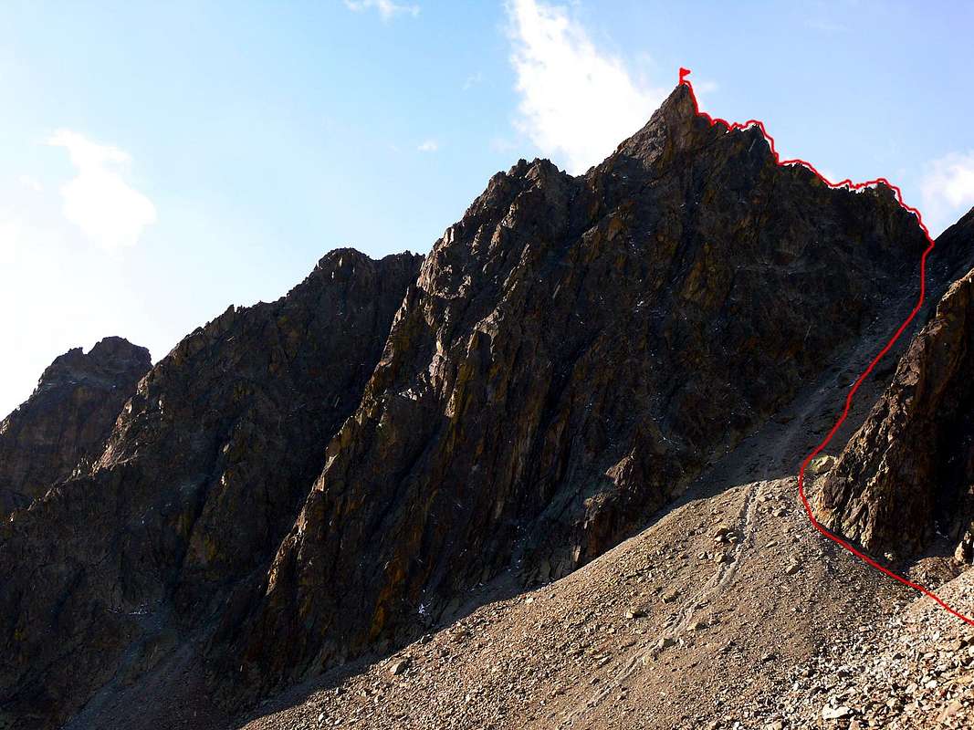
From Franco Spataro Bivouac (2.619m) or, better, from Crête Sechè Refuge (2.410m) to crossing in West in great gully at base of the "Grand Barmé" Pass or "de la Grande Barme" (2.761m). To climb with attention of the exit-out (II°, exposed and delicated) and the short ridge NW in the Summit. After to climb in progression consecutively by plates (15 metres, in edge to an little jag) and an little gully and to reach the summital pinnacle and the following "carving", by an dihedral about 4/5 metres. To go back in edge at of the steep terminal plate at base and to cross in left (4/5 pitons); to get an small and easy cliff (4/5 metres), in free-climbing, to Summit. The difference in level is about 60/5 meters; the total length is about 80/90 meters. Exposed climb (III°+/IV°+; D-; 3h'00 from Bivouac, 3h'30 from Refuge).
Dal Bivacco Franco Spataro (2.619 m) o, meglio, dal Rifugio Crête Sechè (2.410 m) traversare verso Ovest in direzione del gran canale alla base del Colle del Grand Barmé o de la Grand Barme (2.761 m). Risalirlo facendo attenzione all'uscita (II°, delicato) e per la breve cresta NW in vetta, superando consecutivamente in progressione delle placche (15 metri sul filo fino a un piccolo dente), e un canalino. Raggiungere il torrione sommitale e un successivo intaglio per un diedro di 4/5 metri, riportandosi sul filo alla base della ripida placca terminale e traversare a sinistra (4-5 chiodi) superando un breve e leggero strapiombo di 4/5 metri in arrampicata libera sino in vetta. Dislivello di 60/5 metri, sviluppo 80/90 metri. Arrampicata esposta. (III°+/IV°+; D-; 3h'00 dal Bivacco, 3h'30 dal Rifugio).
Parents refers to a larger category under which an object falls. For example, theAconcagua mountain page has the 'Aconcagua Group' and the 'Seven Summits' asparents and is a parent itself to many routes, photos, and Trip Reports.

 5579 Hits
 81.84% Score
 14 Votes