
-
 6534 Hits
-
 90.81% Score
-
 33 Votes
|
|
Mountain/Rock |
|---|---|
|
|
45.88586°N / 7.38710°E |
|
|
Valpelline |
|
|
Mountaineering, Trad Climbing, Sport Climbing |
|
|
Summer |
|
|
9711 ft / 2960 m |
|
|
Overview
Vierge de l'Aroletta 2960 m
Vierge de l’Aroletta is a gneiss-granite pyramidal peak rising South to Col de l’Aroletta, one of the highest summits in the subgroup Costiera dell'Aroletta, belonging to the Pennine Alps. Its evocative place name means literally “Ridge of the little Arolla pine”, an autochthonous conifer of this area. This fine peak is situated nearby other different rocky towers, like the Trident de l’Aroletta, the Aiguille de l’Aroletta, the Aroletta Superiore and Bec Noir de l’Aroletta, and also surrounded by higher peaks, like Mont Gelé m. 3518, Becca Rayette m. 3529, Becca Chardoney m. 3447 and M. Berlon m. 3128 .
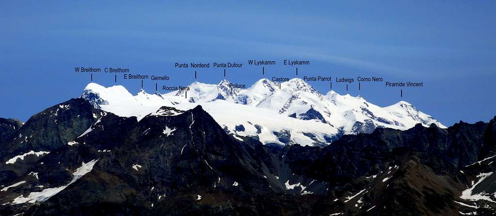
From the summit the mountaineer can enjoy an extraordinary view all around over the neighbouring peaks of Pennine Alps and towards a lot of summits running along the Italy-Switzerland boundary, like Cervino-Matterhorn, Breithorn and other high summits of Monte Rosa Group. The “Vierge” shows a wide ESE face built by compact and good slabs, overlooking the middle section of the Comba di Crète Sèche. Nowadays we can count different fine climbing routes on very good quality “gneiss” on this interesting face: in addition to the pre-existent classic routes, some full-equipped new ones were climbed in last ten-years period.
History
The peak’s first ascent: the Abbots Joseph Henry and Victor Anselmet on 1919, september the 5th, climbing the North face, a route that nowadays is followed only to down-climb from the summit.
Getting there
Best starting point of the approach path is the little settlement of Ruz m. 1696, situated nearby the village of Bionaz, in upper Valpelline (Aosta Valley).

|

|
Road Access to Ruz-Bionaz
- From Turin and Milan: follow the A5 Motorway and exit to Aosta Est. Follow the road S27 towards Gran San Bernardo Tunnel, getting after about 10 km. to Variney m. 782; here you must leave the road to Grand San Bernardo and turn to right towards Valpelline m. 960, the valley’s main resort. Exit Valpelline, ignoring the road to Ollomont on the left, and carry on along Val Pelline main road. The road is reaching Oyace m. 1377, Bionaz m. 1606, the main resort of the upper valley, and Dzovenno. Leave the main road and turn to right to Ruz m. 1697 (parking).
- From France: you can reach Aosta through Mont Blanc Tunnel or Little St. Bernard Pass.
- From Switzerland: you can reach Variney through the Great St. Bernard Tunnel or the Great St. Bernard Col.

Walking access to Crête Sèche Hut
From Ruz follow the unpaved road (cars not allowed) towards the Baou de Bouque Alp m. 2129 and the Berrier Alp m. 2192, then the path n. 2 rising slant to left and getting to the Crête Sèche Hut and to Spataro Bivouac (2 hours to the hut and 2,30 hours to the bivouac).

|

|
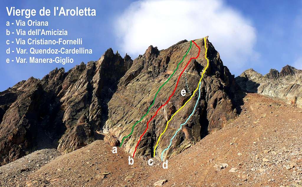
Vierge de l'Aroletta routes overview
Vierge de l'Aroletta Photo Antonio Giani

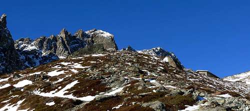
Summit crest
Walking approach to SE face
From Crête Sèche Hut follow the good path n. 2 rising towards Spataro Bivouac and Col of Crête Sèche. After about 15 minutes, when the path is approaching the stream below the rocks, leave it, cross the stream and rise on the big blocks-scree to the bottom of the face. Sometimes, early in the summer, you must cross a snowfield leading to the starting point of Oriana route. From 40 to 60 minutes from the hut.
Classic routes - UIAA Scale According with main italian climbing areas habit, trad routes grades are worded in UIAA Scale, while modern ones are worded in French Scale.
- North Ridge II, 150 m. from Col de l’Aroletta – The first summiters - Nowaday is followed only for down-climbing
- Vierge de l’ Aroletta South Ridge II, III, IV from Col du Grand Barmé to – First ascent A. and J. Charrey 1926
- ENE Ridge, Rosset Ridge III, IV, V, 250 m. – Piero Rosset and Enrico Donatoni 1953
- East Spur, Cristiano-Fornelli-Carena Route IV+, V+ (A0), 400 m. – Carlo Carena, Ennio Cristiano, Natale Fornelli, Antonio Balmamion, Paolo Rattazzini 1966 – This route has two remarkable variants:
- Quendoz-Cardellina variant V, VI, 200 m. – Renato Quendoz and Osvaldo Cardellina 1967- Running on the right of the first section of Cristiano-Carena route
- Manera-Giglio variant IV+, 200 m. – Ugo Manera and Piero Giglio 1966- Running on the left of the middle section of Cristiano-Carena Route
SE Face modern routes - French Scale
- Attenti a quei due 5c, 300 m. Giorgio Bredy and Paolo Marselli
- Via Oriana 5c, 400 m. Marco Vacchiero, Giorgio Vacchiero, Andrea Girandi and Sebastiano Jon
- Via dell’Amicizia 6a+ (5, A0) 400 m. Alessandro Mezzavilla and Marcella Piccinini, 2005

|

|
Descent: abseiling on route "Oriana" (9 rappels) or by 5 rappels along the North side
Red Tape
A wild environment. Cars are not allowed beyond Ruz.
Huts and Bivouacs
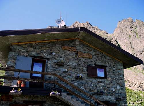
Rifugio Crête Sèche
Crête Sèche Hut m. 2410 C.A.I. Aosta –
Access: 1,45 hours from Ruz
Phone 0039-0165-730030<br/A>Period: in summer open from June to September – In spring: open during the week-end from March to May for ski-mountaineering
Guardian: Daniele Pieiller
Mobile Phone +393470330713
Franco Spataro Bivouac m. 2619, always open, 9 places

Others informations
- Guide Alpine della Valpelline Phone +393338636637
- Bionaz Municipality www.comune.bionaz.ao.it
Where to climb
Best season goes from the end of June to the middle of September
Meteo

Guidebooks and maps

“Alpi Pennine Vol. I” by Gino Buscaini - Collana Guide dei Monti d’Italia CAI-TCI
“Dimensione 4°, Alpi Occidentali” by Lorenzo Barbiè, Vivalda 1993
“Arrampicare a Crête Sèche” – Mini-guidebook available at Crête Sèche Hut
Map IGC “Valpelline-Ollomont-St. Barthèlemy” n. 115 1:30.000