

|
|
Area/Range |
|---|---|
|
|
44.23733°N / 71.38916°W |
|
|
Hiking, Mountaineering, Trad Climbing, Sport Climbing, Toprope, Bouldering, Ice Climbing, Big Wall, Mixed, Scrambling, Skiing |
|
|
Spring, Summer, Fall, Winter |
|
|
6289 ft / 1917 m |
|
|
Overview
Appalachian Range > White Mountains

elevation map
The White Mountains, located mostly in New Hampshire, form a significant and interesting part of the Appalachian Range.
Context: Appalachian Range
The Appalachian Range is among the longest and oldest on the planet, largely shaped by the collision that created Pangea about 400 million years ago. This collision pushed up older bits, some dating back to the creation of the previous supercontinent, Rodinia, about a billion years ago. As a result of this rather complicated history, the Appalachians contain several distinct "terranes". Most of the highlands of New England can be traced to the Iapetus Ocean, whose bedrock was added to Laurentia about 450 million years ago. Different terranes underly southeastern New England, the Adirondacks, and so on. After Pangea slowly broke up (i.e., by around the time of the great dinosaur extinction), most of the Appalachian Range (or rather, the Appalachian-Caledonian Range) remained on the western shore of the newly-created Atlantic Ocean, but the most northeasterly bits were stranded in Greenland, Ireland, Scotland, and Norway.
Much more paleogeology
Today the Appalachians are highly eroded, topping out well under 7,000 feet in the Carolinas. The highest White Mountains are only a bit lower than their Southern peers, comparable to (or taller than) the highest peaks of the Adirondacks of New York, the Green Mountains of Vermont, or the so-called Longfellow Mountains of Maine.
White Mountains: boundaries
The White Mountains are bounded on the west (and north) by the Connecticut River basin, and on the south by the Lakes Region of central New Hampshire. (NH route 25 is a decent southern boundary.) To the east they cross the border into Maine, and subside gradually toward the coast. To the northeast, the boundary is drawn somewhat arbitrarily at Grafton Notch, where the main line of the Appalachians assumes the name of Blue Mountains.
The definition of "White Mountain" given in the previous paragraph is based primarily on recent editions of the AMC White Mountain Guide. Names and boundaries have changed over time. On Sotzman's 1796 map of New Hampshire (published in Hamburg), the name "White Hills" (also given in German, "die Weissen Geburge") refers only to the group that we now call the Presidential Range (and much of the other territory containing the Whites is nearly blank). Though changed to "White Mountains", the scope of the name is similarly restricted on Phillip Carrigain's 1816 map of New Hampshire (which does show rather more of what we now call the Pemigewasset Wilderness and the Sandwich Range). Thomas Starr King wrote in 1864, Two groups of mountains are included under the general title of "The White Hills", one, the Mount Washington Chain, or the White Mountains proper, the other, the Franconia Range, of which Mount Lafayette, a thousand feet lower than Mount Washington, is the highest summit." A county map from 1880 shows the name "White Mountains" spanning its modern extent, though an 1896 promotional map published by the Portland & Ogdensburg Railroad still distinguishes the "White Mountains" from the "Franconia Mountains" - which seem to be everything west or south of what we now call the Presidentials. (Interestingly, the 1896 railroad map gives the correct height of Mt Washington but the 1880 county map says "8300 ft"; Carrigain's 1816 map included a note that it "could not exceed 7800 ft".)
The name "White mountains" is a bit hard to reconcile with their appearance, though so are nearby ranges and peaks like "Blue Mountains" and "Black Mountain". Wikipedia has an (unsourced) assertion that the Whites are named for the amount of reflective mica in their rocks, but I don't believe it. The Whites (even the Presidentials, which do have some visible rock) just aren't pale or shiny at all. My best guess is that the range was named in spring or fall when there was snow on the peaks but not the lowlands. Indeed, among the earliest writings about the region is Josselyn's 1672 account of his two voyages, which mentions "the North-West wind coming over land from the white mountains (which are always (except in August) covered with snow)".
Recent geology
Most of New England was subjected to repeated glaciations, and the signs are everywhere if you know what to look for: U-shaped glacial valleys, kettle ponds, moraines, glacial cirques, huge erratics (boulders) in unlikely places. The glaciers stripped the mountains down to their magmatic bones, which is why New Hampshire is synonymous with granite. Today, though, ice can only be found in the winter (though it lingers a while in a few canyon-like gullies and cave-like spaces), and long ago the forests re-grew on all but the highest peaks (and a few lower peaks cleared by forest fires).
Terrain and conditions: what to expect
Mountains that reach treeline at all are rare in the eastern US. In the Whites, those of the lower, accessible peaks blessed with bare summits are usually packed with summer visitors, and the high zones of alpine tundra, notably the Presidential Range and Franconia Ridge, attract many visitors as well.
There's not much here that would challenge an experienced Alpinist or Andinist, at least in summer: no glaciers, and every major peak has at least one non-technical route. In a comparison of overall ruggedness, the Whites rank well below any major world range you care to name. Which doesn't mean that easy strolls are your only option: technical climbers can find some quite respectable - indeed, classic - cliffs and ravines for rock and ice climbing. Don't let the low elevations and lack of sharp peaks deceive you: the valleys are deep, the terrain can be rough and boulder-strewn, and the weather is unpredictable enough to cause a handful of fatalities in most years.
Rock and Ice Climbing
Here are a few stand-out spots with well-documented routes:
Cannon Mtn has a big cliff with rock and ice routes
Cathedral Ledge is a classic vertical bluff
Whitehorse Ledge, within shouting distance of Cathedral, is most famous for run-out slabs.
Huntington Ravine on Mt Washington has some classic routes in an alpine setting
Frankenstein Cliff does not yet have its own SP page, but the Standard Route does.
The sport-climbing mecca best known as "Rumney" is almost unrepresented on SummitPost, but you can find driving directions on the page for Rattlesnake Mountain and a few photos to whet your appetite in the attached Rumney Rocks album.
General
Much of the area of the White Mountains is included in the White Mountain National Forest, and some of the rest is included in state parks. This means that most of the Whites have remained relatively undeveloped, with some exceptions including downhill ski resorts and the Mt Washington auto road.
The highpoint of the White Mountains, Mt Washington (6,288'), is the highest point in the northeastern U.S.
The Whites are a very popular destination for hiking, skiing, and leaf-peeping, lying within easy reach of cities such as Boston.
The Appalachian Trail winds across this range, passing over or near many of the highest peaks.
Ranges of the White Mountains
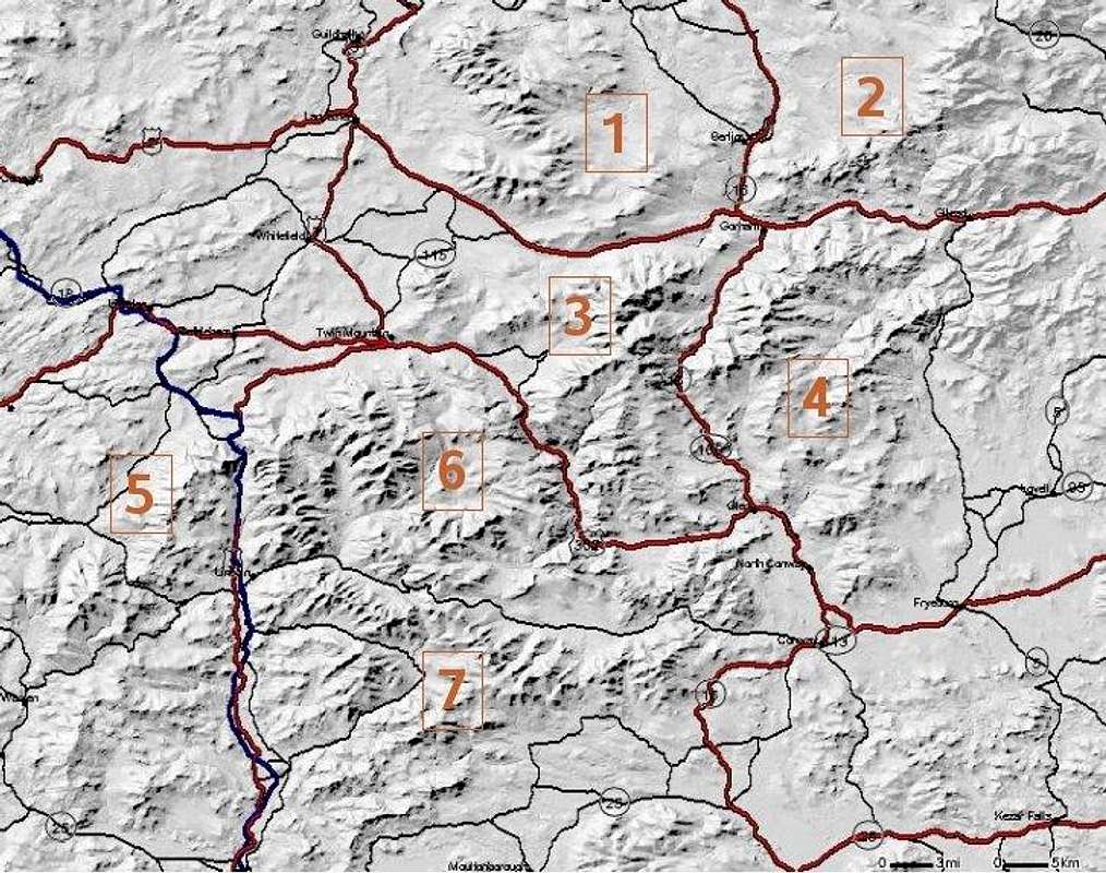
1. Pilot Range
 The Horn
This remote area is long on trees and solitude but short on alpine qualities despite respectable elevation and prominence. Local usage recognizes two ranges (separated at Bunnell Notch), but the Pliny Range is arguably a southern extension of the Pilot Range. Best views are from The Horn (3,905ft). Ranges: Pilot Range Highpoint: Mt Cabot 4,170ft
Pliny Range Highpoint: Mt Waumbek 4,006 ft
2. Mahoosuc Range
 Mahoosuc Notch
The Mahoosucs, last bastion of the White Mountains as you head north and east, lie remote and rugged, across the Maine-New Hampshire border. They stretch from the Androscoggin River 30 miles north to Grafton Notch State Park in Maine. The most famous and most climbed peak in the range is Old Speck from Grafton Notch.
3. Presidential Range
 Mt Washington
The pride of the Whites, with its highest and most rugged peaks and its largest expanse of alpine tundra. Mt Washington draws hordes of tourists and regularly kills a few of them. Several named sub-ranges exist, but get very little attention.Ranges: Presidential Range Highpoint: Mt Washington 6,288' Subranges: Southern Ridges Highpoint: Mt Isolation 4,005' Cherry-Dartmouth Range Highpoint: Mt Deception 3,671'(trailless); Other notable peak: Mt Martha 3,563'
4. Carter and Baldface Ranges
 South Baldface
The Carter Range lies east of Pinkham Notch/US16 and in the shadow of the better-known Presidentials. Indeed, for fantastic views of the Presidentials, it doesn't get much better than from the crest of Wildcat Mountain 4,462' or Mt. Hight 4,675' in the Carters.
Farther east, and even more obscure, is the small Baldface-Royce Range. This range of five or six peaks lies along the Maine border and is separated from the Carters by the scenic Wild River. The main peaks of the range are North and South Baldface (with open views since a fire last century) and East and West Royce.
5. West of Franconia Notch
 Cannon
This area includes Mount Moosilauke, whose bald summit provides a dramatic welcome to Appalachian Trail hikers entering the Whites from the south. It also includes the west side of Franconia Notch, a line of peaks running from South Kinsman to Cannon. The most spectacular feature of this area is unquestionably the thousand-foot-tall Cannon Cliffs, site of the recently-fallen Old Man of the Mountain featured on New Hampshire license plates and highway signs.Ranges: Cannon-Kinsman-Moosilauke (name and extent unsettled - Moosilauke is a bit isolated from the others). Highpoint: Moosilauke(4802 ft)
6. Greater Pemigewasset
 Lafayette
Boundaries: US 93, NH 112, NH 3, NH 302Much of this area lies within the Pemigewasset Wilderness. State parks define the west (Franconia Notch) and east (Crawford Notch) borders. It includes the Franconia Range, the highest outside the Presidentials, and at least as popular thanks to easy access and free parking on Interstate 93. At the eastern end of this region, the Whitehorse Ledge and Cathedral Ledge in the town of North Conway provide accessible rock-climbing.Ranges: Franconia Range Highpoint: Mt Lafayette 5,260 ft Twin Range Highpoint: South Twin Mtn 4,902 ft Willey Range Highpoint: Mt Field 4,340 ft
Other notable peaks: Mt Carrigain 4,700 ft
7. Sandwich Range
 Chocorua
This range encompasses all of the Whites south of Route 112 (which runs from Lincoln to Conway) and north of Squam Lake. On its southern border a set of small peaks forms the Squam Range by its namesake lake. On the eastern end, Mt Chocorua stands nearly alone, and is also alone in having a barren summit with completely open views. Sandwich Range Highpoint: Mt Osceola 4340ft Other notable peaks: Mt Chocorua (3,475 ft) subrange: Squam Range Highpoint: Mt Morgan 2,240 ft
Getting There: Planes, Trains, Automobiles
This section is for info you'd need if coming to New Hampshire from far away.
Short version: satisfying transportation options are few. You're probably best off renting a car at a major airport.
Airports
Manchester (MHT) is your best bet if you want to land in New Hampshire and don't own your own small plane.
If your airline does not have service to Manchester, Boston's Logan Airport is little more than an hour's drive further south.
Train Stations
Amtrak's website lists several stations including Berlin, Conway, and Lincoln, (see map) but I wasn't able to find any trains that actually serve them. I think thesea are actually bus stations (see next section).
Bus service
See NewHampshire.com bus listing for links including:
Concord Trailways
Amtrak Thruway bus service
Charter Buses
Apparently a popular way to visit the region. Try your favorite yellow pages or search engine.
Shuttle Services
AMC Hiker shuttle -stops at certain trailheads twice a day
Hitchhiking
Legal in New Hampshire as long as you stay on the shoulder, not the pavement. (Ditto for Maine, which also prohibits thumbing on interstates or after dark.) The U.S. attitude to hitchhiking and hitchhikers is generally fearful, but the farther from the main highways you go, the friendlier the people you'll find.
Resources for Carpooling
Views from the Top trip planning board
AMC hiking bulletin board
Summitpost East Coast discussion board
Summitpost Partners board
Land Ownership and Red Tape
Much of the Whites are in the WMNF and state parks, but hikers will also encounter private land, whether held by institutional owners like Dartmouth College or private individuals. Rules will vary depending on whose land you're on. Also, certain areas within the WMNF are designated wilderness areas with some additional rules.
In any given year there is usually at least one trail involved in some kind of rights dispute, plus a couple of trails with limited access due to bridge repair and whatnot. Your first step should be to consult a map; to get the very latest status for a particular trail, you may have to call the organization responsible for maintaining that trail, or you can try asking a quetions on an online message board.
maps
huge (20MB) map of the region in PDF format
Excellent trail maps (along with much other useful info) are included in the book White Mountain Guide, published by the AMC. These maps are consistently updated - meaning that, unlike maps from most other sources, they show accurate locations for all of the trails that have been re-routed in the past couple of decades.
Links to online maps can be found in the margins of Summitpost pages. Another good source for online topographic maps is Acme Mapper; Caltopo is even better.. You can also order online or paper maps from the USGS through resellers such as this one.
For trails in state parks, you can usually find a map of the park on the state park's website (see Resources below).
parking
For trailheads within the WMNF, there is a parking fee which is currently $3/day per car. You can buy discount passes in advance (see the links page), or pay at the trailhead using self-service envelopes.
There is no parking fee charged at any of the state parks in the Whites.
Trailheads with roadside parking lots outside the border of the WMNF (Appalachia, for example) are fee-free.
In a few places trailheads coincide with privately-run facilities such as downhill ski resorts, the Cog Railway, or Crawford Notch Visitors center. In such cases there may be designated hiker's parking which is distinct from the general parking area.
In a few places private landowners make their parking lot available for hikers' use (especially in winter), sometimes in exchange for a nominal fee. This sort of arrangement will usually be noted on the appropriate mountain or route page on Summitpost.
Parks, National Forest, etc
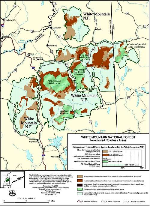
Inventoried Roadless Areas within WMNF
The White Mountain National Forest, managed by the US Forest Service, includes a great many peaks and trails in the Whites.
For the latest WMNF Backcountry rules (camping, hiking, fires), see the links page.
Next in importance are the state parks. Those in New Hampshire are managed by the NH Division of Parks & Recreation, and include:
Franconia Notch
Crawford Notch
Mt Washington's summit
The parks are free, with free parking. [But:if you're planning to drive to the top of Mt Washington, you must pay a fee to use the privately-run road.] No camping except in the designated campgrounds.
Maine's Grafton Notch State Park, defining the northeast border of the Whites, also deserves mention.
Where the Appalachian Trail runs over private land, it is usually protected by an easement covering a narrow corridor (often 1,000 feet wide) along the trail. The section of the A.T. in the Mahoosuc range (managed by the AMC) is the most relevant example.
Camping
WMNF developed campground details (eg, which ones take reservations...); map
WMNF Campground Closings
NH State Park Campgrounds
private campgrounds: NH Campgd Owners' Assoc directory
Cabins on the major peaks include the AMC High Mountain Huts and the Randolph Mountain Club huts.
Three out-of-the-way cabins operated by the WMNF can be reserved from the bottom of this drop-down menu.
Backcountry camping is permitted in the WMNF (subject to some rules), but forbidden in the state parks.
Hunting & Fishing
NH Fish & Gamefishing within the WMNF
hunting in the WMNF
Weather and Other Hazards
weather hazardsExposure is a leading cause of death in the Whites. The section on Preparing for the Weather on the Twin Range page applies equally well to most of the Whites. In short, be prepared for snowfall as early as October, followed by a couple of months of cold grey misery before winter really sets in. Winter is a beautiful time but obviously has its own hazards. Spring (with rain and mud) is perceptible by April but snow can still fall as late as June - which is how long some of the smaller roads will remain closed. Summer is usually hot, hazy, and humid - carry plenty of water.
The summit of Mt Washington is in a class by itself, with snow possible any day of the year and hurricane-force winds quite common (but many calm, hot days too in summer). Overall, though, weather in the Whites is fairly typical of New England (though slightly colder at altitude) - rarely deserving of superlatives, but famously variable.

collision hazard
After weather, your greatest risk in the Whites is probably driving your car into a deer or moose. There are no grizzlies here, and so far most of the black bears have not become habituated to humans. Bear canisters are not yet required anywhere, but are a good idea nonetheless - they'll also work against raccoons, foxes, squirrels, chipmunks and mice (the latter are a real nuisance in certain campsites and shelters). As of summer 2006, I am not aware of any confirmed sightings of cougar or wolf in the Whites. Coyotes are definitely present but not seen very often.
poisonous critters
None, or almost none. In theory both rattlesnakes and copperheads live in the area, but they're quite rare. I've never seen either.
insects
The Whites are home to several species of biting fly, most notorious of which are the black flies which swarm in spring (and have a bite like a paper-punch) but then dissipate. Mosquitoes are a significant nuisance as well. Bees and wasps will leave you alone if you don't disturb them, with the partial exception of "yellow jacket" wasps who are fond of sandwich meat, soda, and other human foods.
Ticks, fleas, and mites [yes I know, only fleas are actually insects] can be found in season. Black-legged ticks are carriers of Lyme disease, which is widespread in New England. It's fairly easy to cure an infection, but it's easy to misdiagnose and can cause permanent damage if left untreated. A black-legged tick nymph is only about 1mm long, so they're easy to miss even if you check yourself frequently. Most mountain trails in the Whites have extremely low incidence of ticks, but consider long pants and insect repellent if you're blazing your own path through fields or woods at lower altitudes.
Facilities Stewardship
Responsibility for maintaining trails and other facilities is shared among a number of organizations, all of whom accept volunteer help.For much more info about trail maintenance, please visit the Trails Maintenance page at NewEnglandWaterfalls.com
Here are the trail maintenance organizations in the White Mountains, in no particular order:
- Appalachian Mountain Club ("AMC")
- White Mountain National Forest (U.S. Forest Service) - Saco or Pemi District ("USFS")
- Wonalancet Outdoor Club ("WOC")
- Randolph Mountain Club ("RMC")
- Chatham Trails Association ("CTA")
- Cohos Trail Association ("CTA")
- Maine Appalachian Trail Club ("MATC")
- Dartmouth Outing Club Cabin & Trail group ("DOC")
All the above have particular geographic areas of responsibility, the following club takes a different approach:
In nearby regions:
- Belknap Range Trail Tenders ("BRATTS")
- Lakes Region Conservation Trust ("LRCT")
Terrain & Vegetation
Topsoil is in short supply - most ground is boggy, or rocky, or both. A thin skin of decaying organic matter suffices to support the forests that dominate the region. Centuries of logging have driven some species of hardwood to extinction and changed the complexion of almost every hidden glen, but the forest remains.At lower elevations you have hardwoods such as oak and maple, sprinkled with pine, hemlock, cedar, etc. These woods are rather pleasant to explore (if you don't mind the bogs and rocks) - spacious and sunny, and they turn spectacular colors in the fall.
As you climb you find stands of birch with increasing frequency. These are, if anything, even more welcoming to hikers - widely spaced trunks with no low branches, and an understory of fern or hobblebush that is often only waist-high.
Somewhere above 3000 feet, however, the temperate deciduous forest gives way to boreal taiga: spruce and fir. These often form impenetrable thickets, disrupted only by fir waves in which fallen logs and jagged stumps are obscured by saplings. Bushwhacking in these conditions requires impressive map and compass skills, great patience and mental strength, and a high pain tolerance. Things only get worse as you approach treeline (usually around 4700 feet) and the trees become stumpy and twisted. Once above treeline, all you have to worry about is the weather (see above).
Resources
weather etc
Online weather services such as Weather Underground (www.wunderground.com) will have forecasts up to ten days in advance for valley towns such as Lincoln, Conway, or Berlin. Accuracy is about what you'd expect for weather forecasting in New England - not very good, especially when it comes to critical questions like "how much will it snow?". In any case, conditions on the higher peaks will often be rather different than in the valleys. For that you'll want to check the Higher Summits Forecast on MountWashington.org, where you'll also find webcams, avalanche forecasts for Tuckerman and Hungtington ravines, and other info. Links to many more weather resources can be found on Views From the Top and on Summitpost's Mt Washington page.New in January 2010! Trails NH collects recent trail conditions reports on a map interface, plus links to weather reports (including snow cover).
misc information
View Guide: Identifying Peaks
Enter a location into Peak FinderOnline Bulletin Boards
SummitPost East Coast message boardViews from the Top - trail condition reports and message boards
AMC Hiker Journal bulletin board
Other websites
Hike The Whites a large website devoted to the White Mountains, with both good info and many useful links. (Formerly known as the Dartmouth White Mountain Info Server.)Mohamed Ellozy's Peak Bagging site Concise and well-organized coverage of the 4,000-footers.
Papa Bear has hiked virtually every peak in New England, his firsthand reports are indexed according to the popular peak-bagging lists.
Downhill Ski
The following is a list of downhill ski resorts in the White Mountains.The resort's name links to its Web page, and the location next to the name is linked to an interactive map.
Attitash (Bartlett)Black Mountain (Jackson)Bretton Woods (Bretton Woods)Cannon Mountain (Franconia)Cranmore (North Conway)Loon Mountain (Lincoln)Snows Mountain (Waterville Valley)Sunday River (N Bethel, ME)Waterville Valley (Waterville Valley)Wildcat (Pinkham Notch)
Tuckerman Ravine (Mt Washington) Tuckerman's Ravine is a challenging backcountry ski spot, with no ski lifts and very real avalanche danger.