

-
 32541 Hits
-
 90.45% Score
-
 33 Votes
|
|
Mountain/Rock |
|---|---|
|
|
45.89929°N / 6.91269°E |
|
|
Mountaineering, Trad Climbing, Big Wall |
|
|
Summer |
|
|
11555 ft / 3522 m |
|
|
Overview
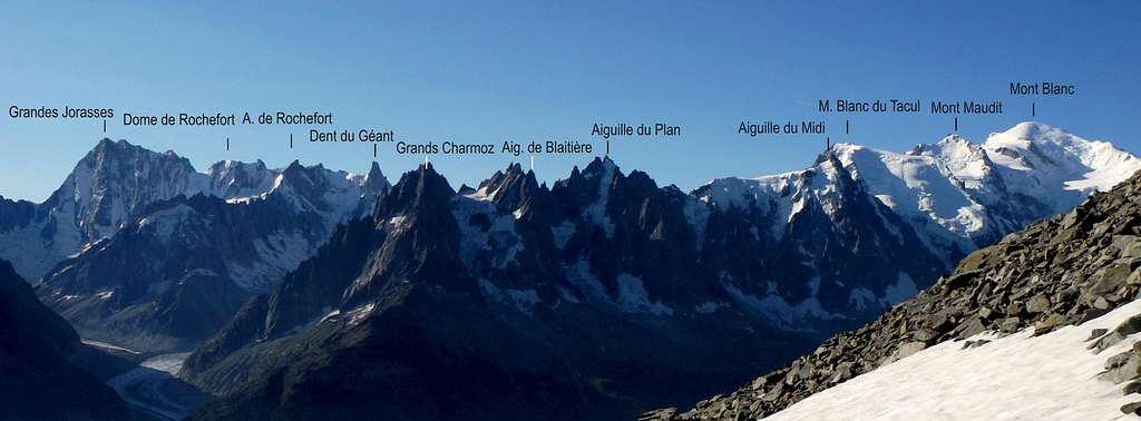
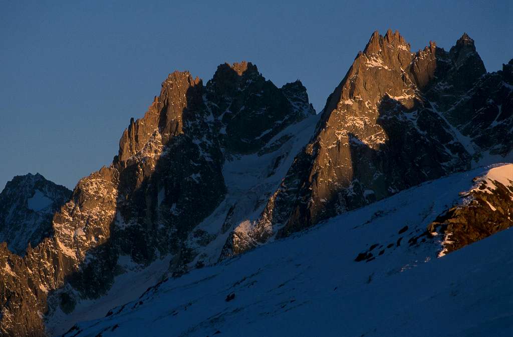
Aiguille de Blaitière
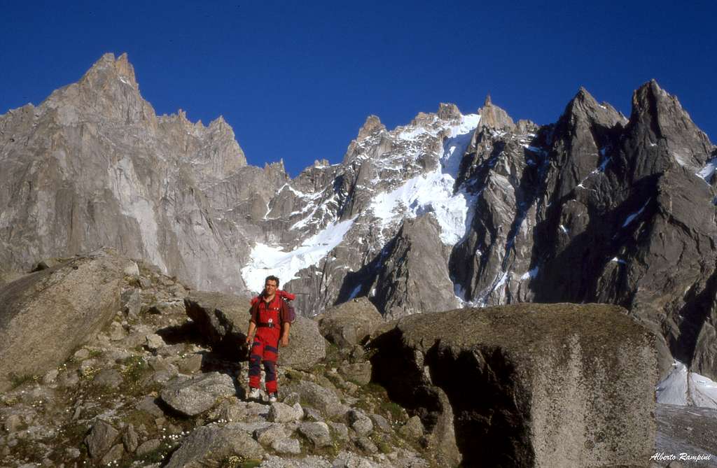
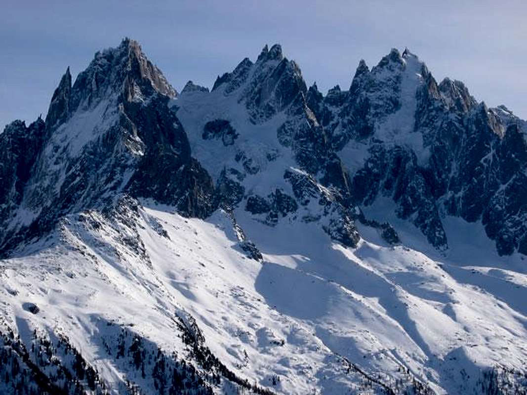
The Aiguille de Blaitière 3522 m is a mountain located in the group of the Aiguilles de Chamonix. From the Mont Blanc summit you first see the Aguille de Midi, then a range with 3 distinct aiguilles. The Aiguille de Blaitière is the middle peak of these ones. This summit is very interesting on the West side for modern rock climbing. The Normal route is a very nice alpine ascent when the couloir Spencer is in good conditions. It usually happens in the begining of the summer season.
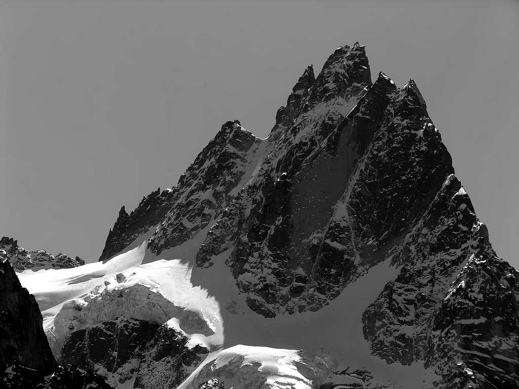
Aiguille de Blaitière is made up of three summits:
- the Central Point (the highest one, 3522m)
- the very close South Point (3521m), only 60 cm lower
- the North Point or Pointe de Chamonix (3507m).
The Central Point and the South Point are separated through the Brèche 3506 m. The Central Point and the North Point are instead separated through the wide Brêche de Blaitière 3449 m.
The mountain has 4 faces:
- SW face with nice rock routes
- NE face with the "voie normale" from Glacier des Nantillons
- East face from Glacier d'Envers de Blaitières
- SE face, from the major part of Glacier d'Envers de Blaitières
In summer 2007 there was a collapse on the north side of the Pilier Rouge.
History
1873 - Pointe N first ascent (Arête E du Rocher à la Corde) - Ulrich Almer, Johann Fisher, Thomas Stuart Kennedy, James Aubrey Garth Marshall
1874, August 6th - Pointe Centrale first ascent (Arête E du Rocher à la Corde) - Christian et Johann Lauener, Edward Robson Whitwell
1876, July 29th - Pointe S first ascent - Richard Pendlebury, Gabriel et Josef Spechtenhauser.
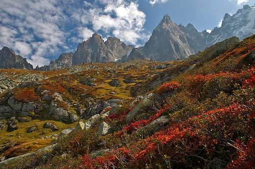
Getting There
The valley of Chamonix is the place to get started for any of the routes on Aiguille de Blaitière. For access to this particular mountain, there are 4 different approaches:
1. From Aiguille du Midi, if you traverse all the Aiguilles de Chamonix in one or two days from Midi to Grands Charmoz.
2. From Plan de L'Aiguille at the first Cable Car for the modern routes on the West Face
3. From Plan de L'Aiguille Hut or Bivouac if you want to climb routes to the top.
4. From the Refuge of Envers des Aiguilles for the Mer de Glace Side.
 |
 |
 |
 |
Normal route
Arete E du Rocher de la Corde, AD
The Normal ascent route to the Central Point takes place from Plan de l'Aguille across the Glacier des Nantillons and with a long traverse gains the Brèche 3506 between the South Point and the Central Point. Across a narrow chimney gets the Central summit. It's the route of the first summiter.
Couloir Spencer
Another Easy route from the Glacier des Nantillons is the Couloir Spencer, AD. It starts from Plan de l'Aguille an it's the quick route to get the summit. Sylvain Saudan was the first extrême skieur to success this route on skis.
Arête Bregeault
Another easy route is the North-East ridge called Arête Bregeault (PD) starting from the Refuge Plan de l'Aiguille.
Other routes
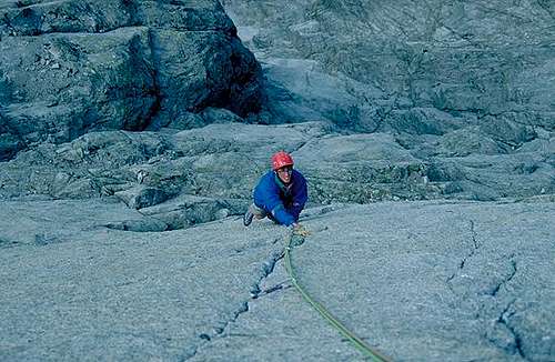
On the East face and SE ridge, there are very fine rock routes:
the Ryan-Lochmatter (D, IV 500 m)
the Leininger (TD, V, 500 m)
the Britishs ( TD, V+) The access is from Refuge d'Envers des Aiguilles.
The southeast ridge of Blaitière, forgotten by modern topos, was once a great classic. Opened in 1937 by Jean and Raymond Leininger, it first offers a very beautiful sunny climb on its edge, then the route switches to the western slope to climb an oblique ramp after crossing a difficult chimney where there remains an old thick rope " Matterhorn type". From time to time you find large period peaks, proof that this route has been traveled for a while.
Pilier Rouge and West face approach
Looking from the Chamonix valley, the Aiguille du Blaitiere appears to the left of the Peigne, beyond the half-hidden Aiguille du Plan. From the Plan des Aiguilles station, the path turns left passing under the moraine of Lac Bleu and remains at the same height passing on the front of the Glacier de Blaitiere. The track goes up the moraine and moves to the left at an altitude of 2500 on the glacier tongue that rises to the base of Piler Rouge. You go to the saddle which returns to the western slope above the Glacier de Blaitiere. This stretch in the summer of 2007 was reached by debris from a collapse on the north side of the Pilier. The track soon reaches the base of Piler Rouge and, subsequently, all the other routes on the West face.
Pilier Rouge routes
- Bobokassa
- Charles Eternue
- Crook-Penning
- Deux Goals
- Echec et Marx
- Nabot Leon + Osez Josephine
The West Face has very good rock in some parts. The West pillar is hard, the crack Brown Whillans is famous and the route to the top is a long and technical ascent.
The NorthWest ridge is a long route TD but interesting to do to prepare more technical ascents, (800m, V+, A1).
Red tape
No fees no permits required
When To Climb
The best season is Summer. Make sure you are well informed about glacier conditions though.
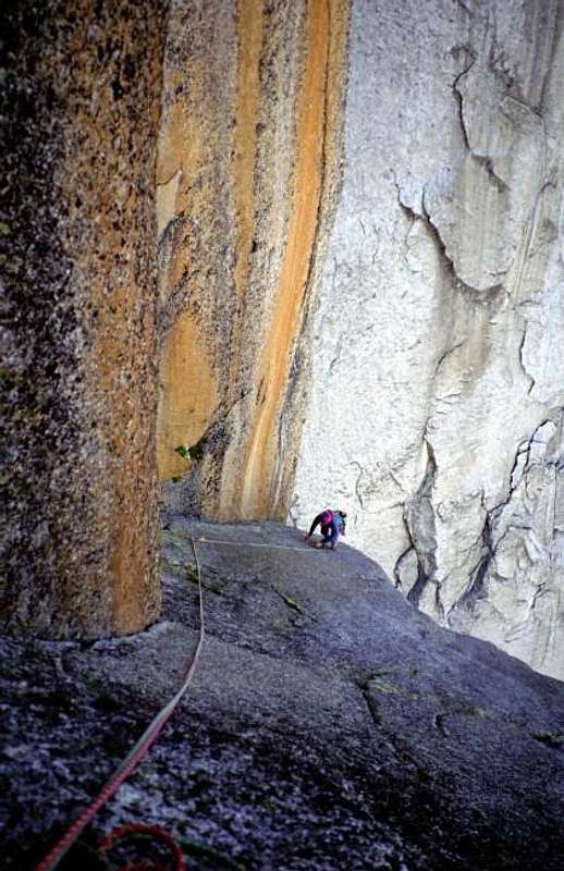 |
Pilier Rouge de l'Aiguille de Blaitiere - Route "Nabot Léon" 5th length, a wonderful climb. Photo by Bernhard Sauer |
Accomodation
Chamonix is a primary destination, offering various kind of accomodation (hotels, huts, gites, renting rooms). Numberless campsites are situated both in the Northern and Southern ends of the town. Main campsites:
- Camping la Mer de Glace - Les Praz (3 km. North to Chamonix) +33(0)450534403
- Camping les Deux Glaciers - Les Bossons (3 km. South to Chamonix) +33(0)450531584
- Camping les Arolles - close to the centre of Chamonix - +33(0)450531430
- Camping les Cimes - Les Bossons (3 km. South to Chamonix) +33(0)450535893
- Camping les Marmottes - +33(0)450536124
- Camping Glacier d'Argentière - Argentière (8 km. North to Chamonix) +33(0)450541736
There is a nice place to Bivouac under Aiguille du Peigne. With a small lake and good water. See also the Aiguille du Peigne page itself.
General info
- Office de la Haute Montagne de Chamonix Phone +33 0450 532208 - - Office de la Haute Montagne de Chamonix
- Cable-car informations Phone +33 0450 532275 Compagnie du MontBlanc
- Office du Tourisme de Chamonix Phone +33 0450 530024 Chamonix Mont-Blanc
- Chamonix Mont-Blanc
- Train-Infos
Meteo and Mountain Conditions
You can get excellent information about weather, conditions and routes at the "Compagnie des Guides de Hauts Montagnes" (cieguides-chamonix.com, tel: 50 53 00 88) or the "Maison de la Montagne" at the "place de l'Église" in Chamonix. Don't be afraid to step into their building, its common practice, people are constantly walking in and out. By no means you are expected to hire a guide when you visit. For weather reports you can call 50 53 03 40. In winter the number 50 53 17 11 gives snow conditions and avalanche risks. Mountain rescue is secured by the "Gendarmerie de Haute Montagne", 50 53 16 89.
Guidebooks and maps
"Monte Bianco Vol. 2" Guida Vallot by François Labande
"The Mont Blanc Massif - The 100 Finest Routes" by Gaston Rebuffat - London 1996
Map
3630 OT (Chamonix) Institut Géographique National - 1:25000