-
 18422 Hits
-
 93.1% Score
-
 41 Votes
|
|
Mountain/Rock |
|---|---|
|
|
45.98710°N / 7.01170°E |
|
|
Mountaineering, Trad Climbing |
|
|
Summer |
|
|
11400 ft / 3475 m |
|
|
Overview
Aiguille Purtscheller 3475 m
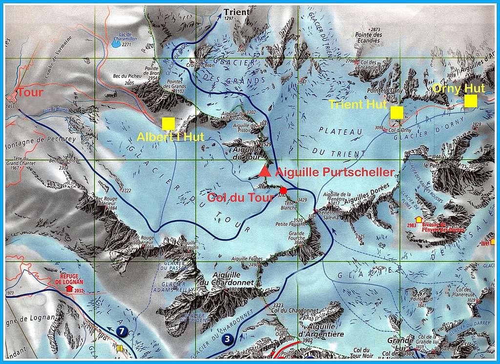
Aiguille Purtscheller is a secluded spire in shape of a pyramid, located on France - Switzerland border ridge, between Trient and Tour basins, in the neighbour of Aiguille du Tour on the West side of the Trient plateau. The exact location of the needle is between the Col du Tour and the Aiguille du Tour, from which it is separated by the Purtscheller pass (3383 m). Aiguille Purtscheller is made of the excellent Mont Blanc red protogine granite and provides a fine climb along its classic and advisable South Ridge.

The routes on the West wall, once interesting, are now impassable due to some landslides. Not far away from the busy Aiguille du Tour, the Purtscheller needle is a haven of peace. The peak can be approached both from France and Switzerland. The french access is from the Refuge Albert Premier across the Col Sup du Tour. On the Swiss side, you must cross the Trient plateau, coming from the Cabane d'Orny or from the Cabane du Trient.

Getting There

Swiss access to Orny and Trient Huts
You will need to get to Martigny, than follow at first the road to Sambrancher, than to Orsieres and to Champex lac. If you are coming from Italy or the Grand St. Bernard area, you will only have to head for Orsieres, than Champex Lac. Once in Champex head for the La Breya Chairlift, once at the top of the chairlift follow the trail that will first pass the Cabane d'Orny and than continue on the Orny Glacier to the Cabane de Trient.
French access to Albert Premier Hut
To get there you must get to Le Tour at the top end of the Chamonix Valley. From Le Tour you have two options: either take the lift up to 2200 m or start from the village. Both possibilities are on well marked trails.
History

The spire was devoted to the Austrian mountaineer Ludwig Purtscheller (Innsbruck October 6th, 1849 - Bern March 3rd 1900) Switzerland), who first summited the peak in 1890, June 17th. In the late 19th century he was known as one of the best mountaineers in the Alps, where he had climbed over 1700 mountains. He is best know for his first ascent of Kilimanjaro in 1889 together with the German mountaineer Hans Meyer. He died in 1900, during an attempt to climb the Dru in Mont Blanc Group.
- S ridge : R. Aubert, René Dittert, Francis Marulaz, 16 mai 1943
Routes Overview
The most attended routes are:
- Arête Sud Classique (South Ridge) French 5b max
- Arête Sud Integrale (South Ridge integral) French 5b max, 5a obbl., 200 m.
- North-East side Normal route, an easy ascent - Alpine PD

Approach from Albert Premier Hut
From the shelter take the path heading to SE towards Tour Glacier. Getting the glacier rope up and rise on glacier, passing to the North the Signal du Reilly 2883 m., getting the Col du Tour. From here head to the V gap, where the Arête Sud Classique starts.

Approach from Orny and Trient Huts
Reach the Plateau du Trient and before joining Col du Tour turn to NW towards the V gap, where the Arête Sud Classique starts.


Arête Sud Classique (South Ridge) report
L1 - From the V gap climb the wall of the first pinnacle, cut by a crack, traverse on the Trient side and reach the summit of the first pinnacle. 5a, 5b. A short equipped abseil to descent to the gap between the first and the second pinnacle.
L2 - Cross on a little slab on Trient side, then by a succession of walls and gaps reach a short slanting corner. 4a-4c, 45m.
L3 Skirt to the left the summmit of the second pinnacle to reach the next rocky saddle below a big rocky step (third pinnacle), overhanging near the top. Bypass it descending on Trient side (East) to reach a ledge and traverse it about 15 m. 4a downclimbing.
L4 Climb a superb chimney-crack with large yellow flakes, finally follow the crest of the ridge 4c, 5a 45m
L5 Pass behind a spike, traverse 10m horizontally to reach the last gap, then climb up a chimney 20 meter high to the summit. 4b


The Arête Sud Integrale (South Ridge integral), a longer way to get the summit, adds some pitches to the Arête Sud Classique. Start directly climbing up from Col du Tour: climb two small pinnacles, then the Aiguille du Col du Tour, bypass others small pinnacles on Trient side before getting to the V gap, where the Arête Sud Classique starts.
Descent: two different ways
- rapping down (2 x 30 m., equipped) on Trient side reach Trient glacier slopes, then Col du Tour
- rapping down on NE side (3 abseils, equipped), getting the starting point of Normal route - Useful choice for people who have climbed the Normal route or planning to climb also Aiguille du Tour
See here more info about the climb: Climb on Aiguille Purtscheller
Red Tape
No fees, no permits and no particular restrictions
Huts


- Cabane d'Orny m. 2831 SAC (Swiss Alpine Club “Les Diablerets”) - Hut's phone : 0041 277831887
Situation: Swiss side of Mont Blanc Group - Left shore of Orny Glacier, between two little lakes
Open: open all year long, guarded in summer from 10.06 to 20.09
Size: 90 persons + 30 in the winter-shelte
Guardian: Patricia and Raymond Angeloz
- Cabane du Trient 3170 m SAC (Swiss Alpine Club “Les Diablerets”) - Hut's phone : 0041 277831438
Situation: Swiss side of Mont Blanc Group - Col d'Orny - Open: from middle March to middle May and from middle June to middle September
Size: 140 persons + 40 in the winter-shelter - Guardian: Mélanie & Olivier Genet Rte du Coteau 29 1927 Chemin-Dessus
- Refuge Albert Premier m. 2711 CAF (French Alpine Club "Chamonix) - Hut's phone: 0033 04.50.54.06.20
Situation: French side of Mont Blanc Group - Shore of Le Tour Glacier - Open: from March to April and from July to September
Size: 148 persons + 20 in the winter-shelter - Guardian: Paul Laborde

Where to stay in Chamonix
Chamonix is a primary mountaineering destination, offering several accomodations (hotels, huts, gites, renting rooms). Numberless campsites are situated both in the Northern and Southern ends of the town. Main campsites:
- Camping la Mer de Glace - Les Praz (3 km. North to Chamonix) +33(0)450534403
- Camping les Deux Glaciers - Les Bossons (3 km. South to Chamonix) +33(0)450531584
- Camping les Arolles - close to the centre of Chamonix - +33(0)450531430
- Camping les Cimes - Les Bossons (3 km. South to Chamonix) +33(0)450535893
- Camping Glacier d'Argentière - Argentière (8 km. North to Chamonix) +33(0)450541736
- Camping les Marmottes - +33(0)450536124
When To Climb
Best period goes from July to September
Meteo
Meteo Chamonix
MeteoSwitzerland
Useful information
Office du Tourisme de Chamonix - Phone +33 0450 530024
Office de la Haute Montagne - Chamonix - Phone +33 0450 532208
Compagnie du MontBlanc
Cable-car informations Phone +33 0450 532275
Guidebooks

"6a max – Savoie et Haute Savoie" by Philippe Brass, Guillaume Vallot – 2004
"Escalades choisies Mont Blanc Aiguilles Rouges" - 2009
"La chaine du Mont Blanc, Guide Vallot III – Aiguille Verte – Triolet – Dolent – Argentière – Trient" by Lucien Devies, Pierre Henry - 1975
Topo : Sommets du Mt-Blanc, Laroche/Lelong, Glénat. Vertical n° 26 08/2002
Maps
Carte: IGN 3630 OT