
|
|
Mountain/Rock |
|---|---|
|
|
46.56860°N / 114.2101°W |
|
|
Ravalli |
|
|
Mountaineering, Ice Climbing, Scrambling |
|
|
Spring, Summer, Fall, Winter |
|
|
8411 ft / 2564 m |
|
|
Overview
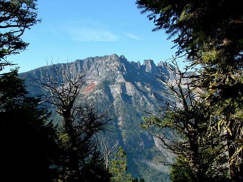
The Bass Creek Crags are a group of mostly flat topped granite spires that sit at the eastern most edge of the ridge that seperates Bass Creek and Kootenai Creek. This ridge reaches six miles west to Bass Peak on the Montana - Idaho border.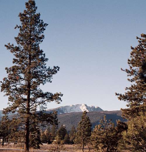
The spires are 200 to 350 feet of exposed granite, and are very steep on all sides. Making non technical routes up several of the spires non existant. There are however a couple 4th class routes up onto the 2 main table tops.
 Bass Creek Crags form the N.
Unlike the St. Joe, St. Marys, Sweeney, and One Horse, ridges, which tend to have rounded shoulders, The Bass Creek Crags have very deep gashes in the granite seperating the spires. From a distance these resemble the locals name for the ridge "Gunsights".
When traveling S. on Hwy 93 from Lolo, the Bass Creek Crags give you the first real inkling of how rugged the Bitterroot Mountains are.
 Bass Creek Crags form the N.
The Gunsights sit just inside the Selway Bitterroot Wilderness area, in the Bitterroot National Forest.
 Luke on the S. Side The Gruff Couloir chute
Getting There
The Bass Creek Crags can be accessed by either the Kootenai Creek or Bass Creek trail heads.The Kootenai Creek Trailhead road is 1 mi. N. of the Stevesnville cut off. Turn W. at the sign and travel 2 mi. to the trailhead parking lot which has been recently expanded to handle fewer cars, and more trucks with horse trailers. It also features a new vault toilet [reasonably clean].This trail head is marked for day use only, but I have parked there for extended trips.
The Bass Creek Trailhead road is 3.5 miles N. of the Stevensville cut off. Turn W. at the sign, an travel 3 miles to the trail head loop.
Use caution leaving valuables in your parked car, as there have been break ins at both of these trailheads.
Both of these trails are well used, and receive reasonable maintanence to the wilderness boundary at 2.5 mi on Kootenai Creek, and 2.0 mi. on Bass Creek. Beyond that boundary, maintenance is spotty, and by no means annual.
Red Tape
There are no fees or permits required to access this area.The Kootenai Traihead is actually on private property, please respect the no tresspassing sign for the first .5 mi. of the trail.
The Bass Creek Trailhead is on Bitterroot National Forest land.
Camping
There is a small campground at the Bass Creek trail head. This is also a nice place for a picnic.The Bass Creek and Kootenai Creek valleys are narrow and deeply cut by the creeks. There is also dense undergrowth along the creeks, this makes camping spots kind of hard to find. None will be secluded until you get 4 or 5 miles up the trail, and the valley gets a little wider.
Important Information
Winter Avalanche ConditionsBitterroot National Forest
Current Weather Conditions
T Sharp - Jan 3, 2007 2:50 am - Hasn't voted
Re: correctionsI think I neglected to recalculate minutes and seconds to dddd. Very embarassing indeed. Corrections made 1/2/07 7:55 pm MDT