
-
 8689 Hits
-
 83.69% Score
-
 17 Votes
|
|
Mountain/Rock |
|---|---|
|
|
46.16488°N / 114.32682°W |
|
|
Hiking, Scrambling |
|
|
Summer |
|
|
8934 ft / 2723 m |
|
|

Overview
Among the things that recommend the Bitterroots to climbers are their ruggedness and remoteness. There are more unnamed peaks than named peaks and more than a lifetime's worth of mountains, routes, cirques, and canyons to explore.
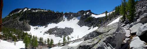
Point 8934, "West Camas Peak," is one of the many peaks that see at most a handful of visitors each year. There is no summit cairn, no register, no easily discernible signs of human visitation. And it has extensive wilderness views in all directions.
It would be easy to argue that West Camas and its close neighbor East Camas Peak are not separate peaks. Going by prominence rules, it would be hard to dispute that argument since West Camas, the higher of the two, does not quite rise 200' from the saddle between the peaks. Therefore, perhaps West Camas is the peak and East Camas is just a bump along the way.
But the two peaks have a different character; West Camas is more rugged both in appearance and actual terrain. And perhaps more importantly, West Camas is not actually on the cirque rim that East Camas is; it is set back just a bit, enough so that rainfall and snowmelt on it do not drain into the cirque of the Camas Lakes. Thus, the separate pages for the two peaks.
Routes Overview

There are four principal routes one might use to climb this peak. Two start from the Camas Lakes Trailhead, and the third starts from the Ward Mountain Trailhead. Directions to the trailheads are in the Getting There section.
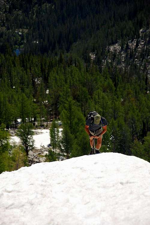
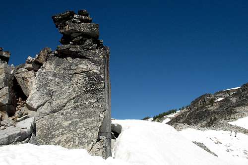
By any of the routes, the final climb to the summit is along dark, sometimes loose rock. Call it Class 2+, though you can turn it into something a little more challenging if desired. The picture to the left illustrates a fine example of that.
Camas Lakes
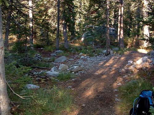
This route is the most direct and is the recommended route if West Camas is your sole objective. From the trailhead at approximately 5600', it is almost 4 miles to 7550' Upper Camas Lake. Most of the way, the trail is in good condition, but it occasionally disappears among granite boulders. With a sense of direction and a good map, you will not get lost. With some patience, you shouldn't have too much dificulty relocating the trail after its occasional short disappearances.
From Upper Camas Lake, East Camas Peak is almost directly west, and West Camas Peak is almost directly west from it. Head a short distance northwest from the lake (there is no longer a trail) and, at about 7800', head more directly west for the cirque rim. Bitterroot bushwhacking can be a bitter thing indeed (groan), but the forest here should be fairly open.
Keep studying the terrain as you climb, and settle on a course that suits you. There is no one way. Although there are some sheer cliffs between East and West Camas Peaks, there are also enough boulder-strewn slopes to facilitate Class 3 scrambling to the ridgeline between the peaks. You can also scramble to the cirque rim south of East Camas, though that would mean taking a southwesterly course from Upper Camas Lake and lengthening the route.
Total distance to the summit is about 5.5 miles.
 Ridge between East and West Camas Peaks-- by thephotohiker
Partial Cirque Traverse from Kidney Lake
 Kidney Lake Trail Junction-- by thephotohiker
This route is a little longer than the Camas Lakes one and involves some extra elevation gain, but it has very little bushwhacking and is more scenic. And the reason it has more elevation gain is that it climbs two other peaks-- Point 8766 and East Camas.
About 2.5 miles from Camas Lakes TH, at around 6,800’ (46.15419 N / 114.27371 W-- coordinates noted by the photohiker), a faint trail to your left leads to Kidney Lake. It is sometimes marked by one or more smallish cairns, but this trail has been abandoned by the Forest Service, and the cairns often have been dismantled or are not there at all. You will miss this trail unless you really pay attention (I never would have seen it had Mike, thephotohiker, not been there to point it out).
The trail makes a short but steep climb to Kidney Lake (about 7350') on a good trail. From the lake, hike to the right along the shore and gain the ridge climbing to the cirque rim above. When I climbed this route, there was moderately steep snow; since I cannot say what snow-free conditions would be like, I would just advise climbers to be prepared for Class 3 scrambling, this advice being based on the steepness of the route.
Atop the cirque rim, turn right to follow the ridgeline over Point 8766 and East Camas Peak. Most of this is Class 2/2+ going, but you may encounter a little Class 3 depending on your exact route.
Total distance to the summit is about 6 miles.
 By thephotohiker
Ward Mountain
Unless you are out to prove something to yourself about how much suffering you can endure, or unless the Camas Lakes Trailhead is inaccessible, you are likely much crazier or much tougher than I am, or both, if you take this route.
From the Ward Mountain Trailhead at 4300', a trail climbs almost 5000' in 6 miles to reach the summit of Ward Mountain. This trail is punishingly steep in places and crosses large stretches of deadfall-filled burn areas (where the sun also bakes you on hot days). Views aren't too exciting, either; you mostly see forested ridges and the development of the Hamilton area until you reach real timberline.
The hardest of the work is over, but you may by now be worn out. From Ward's 9119' summit, you then have to scramble down granite boulders (Class 3, and not hard to run into Class 4 in places) to a saddle at about 8200'. From that saddle, you then head slightly northwest, climbing toward Point 8909, but you eventually want to contour to reach another saddle south of that peak (the saddle is at about 8600'). From there, ascend Class 2 and 3 terrain, gaining only 100-200', to the ridgeline between East and West Camas Peaks.
Total distance to the summit is about 8 miles.
Full Cirque Traverse
If you can arrange to have cars at both trailheads, this makes a long but excellent outing. It is best done from Camas Lakes Trailhead to Ward Mountain Trailhead for at least three good reasons: you will incur less elevation gain, it is much more enjoyable scrambling up the west side of Ward Mountain than down it, and you get to go downhill on the Ward Mountain Trail. That trail is no picnic going down, either, but it beats going up it.
This outing is highly scenic, has little bushwhacking, includes long ridge walks at or above timberline, and climbs 5 peaks. In order, they are Point 8766, East Camas Peak, West Camas Peak, Point 8909, and Ward Mountain.
For details, refer to the Partial Cirque Traverse and Ward Mountain routes above.
This route is around 17 miles, with close to 6000' of elevation gain (by the recommended direction).
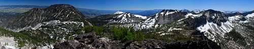 From Point 8909-- Panorama of the Other 4 Peaks-- by thephotohiker
 East Camas Peak
Views of the Peak


Views from the Peak


Gear Needed
Many people, myself included, enjoy Class 3-5 climbing in sandals such as Chacos, Merrells, and Keens, but the off-trail woods approaches make this mountain no place to go that way.
From the trailhead, you won't be able to preview snow conditions on this Peak and East Camas, but unless you know the range is mostly melted out for the summer, you should have an ice axe with you, as snow climbing on any route other than that from Ward is going to be on moderate to steep terrain.
Getting There
The directions are copied, with permission, from the Camas Lakes and Ward Mountain trailhead pages by thephotohiker.
To reach Camas Lakes Trailhead-- Drive south from Hamilton, MT for a little over 9 miles. Turn right (west) onto Lost Horse Road. Drive 2.4 miles to a posted junction with FR 496. Take the right fork (northwest) onto the gravel road and drive for 6.1 mile to the well-marked pull-off for the trailhead.
To reach Ward Mountain Trailhead-- From Golf Course Road (the last stoplight) on the south side of Hamilton, MT, drive south on Hwy 93 about 3.4 miles. Turn right (west) onto Roaring Lion Road (531). Drive 2.5 miles to the intersection with FR 1134. The Ward Mountain trailhead is marked with a small sign on the south side of the road.
Red Tape
Nothing unusual-- visitors should read the trailhead information for specifics.
Camping
Memory and maps suggest there are no developed campgrounds at or near the trailheads. There are campgrounds at Como Lake, which is to the south and will involve a drive of several miles between trailheads. See this page for driving directions.
Backcountry camping does not require a permit, and there are good sites in Camas Cirque.