
-
 14332 Hits
-
 76.66% Score
-
 7 Votes
|
|
Mountain/Rock |
|---|---|
|
|
45.99000°N / 114.37°W |
|
|
Ravalli |
|
|
Hiking, Mountaineering, Trad Climbing, Scrambling, Skiing |
|
|
Spring, Summer, Fall, Winter |
|
|
9185 ft / 2800 m |
|
|
Overview
The Lonesome Bachelor, although overshadowed by its larger neighbors (El Capitan and the Como Sisters), is a very fun peak, and definitely worth the approach. A few quick stats:Elevation: 9,185'
Location: 45.99 N / 114.37 W
Minimum Commitment: Full Day Plus, Exposed Scrambling
 The Lonesome Bachelor, from lakes below
The Lonesome Bachelor sits at the back of Little Rock Creek, North of Darby. Expect a FULL day or a pleasant overnight for this trip. There are many good camp sites at the unnamed lakes below.
Getting There
The day starts at the Little Rock Creek Trailhead.To get to the trailhead, take Highway 93 12 miles South of Hamilton and turn right (west) onto Lake Como Road. The road comes to a junction as you appproach the lake; take the left fork toward the boat launch area. Stay on the main road, passing the boat launch (on the right) until the road turns to gravel. There is a sign for the trailhead, on FR 550. Take that road a few miles to a large pullout area high above Como Lake. You can park here, or the (fairly rough) road continues another couple hundred yard to the "proper" trailhead.
 The Lonesome Bachelor, small in the center. Photo: thephotohiker
Route Desciption
Little Rock Creek Trail.The trail starts with 500+ feet of elevation loss in the first mile. It is a pleasant downhill, but remember that this will be the ass-kicker as you head out to the car at the end of your trip. The trail continues to follow the bottom of the drainage before gaining elevation again. There is one section of particularly not-fun and hard to follow wet trail that often has running water (especially in the spring). Waterproof shoes/boots or sandals might be a good idea for this part.
The trail ends at Little Rock Creek Lake, elevation 6,545 ft. If I remember correctly, it is about five miles to the lake. There is one decent campsite at the East end of the lake, and a couple more on the North side of the lake.
Bushwhack!
Ugh, the fun part. Keep following a faint trail across the North side of the Lake to the lake's end. From here, two odd miles of bushwhacking will get you to the higher (unnamed) lakes. If one stays high (North) of the creek, dense underbrush of the creek bottom can be avoided. The route is sporadically cairned in different places (I have seen cairns both in the creek-bottom and higher up the slope). Basically, there is no easy way here. Just keep heading Southwest with the creek until the upper lakes. There are three upper lakes. You want the middle (farthest) one, at elev. 7,400 ft. When there is no snow, there are numerous great alpine campsites around these lakes.
From the lake, the climb begins. The most prominent couloir is the easiest option to gain the ridge. Depending on the season, this can either be a fun snow-climb or hoofing up a dry scree field. I would recommend an ice ax for the first case. About 800' of elevation gain gets one to the ridge between El Capitan (to the right/West) and The Lonesome Bachelor (left/East).
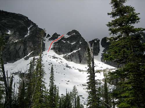 The easiest choice for gaining the ridge. Photo: alpine climber
Climbing!
Now that you have hiked, bushwhacked, and punished your lungs up that couloir into the saddle, the climbing begins. It starts with moderate low-angle scrambling.
 From the top of the col, heading toward the Lonesome Bachelor. Photo: alpine climber
I believe in adventure, so this next section is by no means a detailed "how-to get up the Lonesome Bachelor." (That, and I only remember the route I took was fun and involved trial and error route-finding). I would suggest scrambling (via 2-3 class) across to the South ridge and summiting via the South ridge/Southeast face. The scrambling steepens, and becomes VERY exposed class three scrambling below the summit block. You might want to rope up and protect the summit block, depending on your chosen route. It is very exposed climbing, and depending on the route, class 4-5. The crux for my party was 10-15' of steep vertical just below the summit.
That being said, my party was able to up and downclimb class four/low five without breaking out our rope. We saw no fixed rappel gear, but that is not to say that a large block could (easily) be slung if a rappel were needed.
Descend the way you came, downclimbing and scrambling back to the saddle (where you might as well do El Capitan, too - it is a hoof, but when are you going to want to do that approach again?). Descend couloir and bushwhack back out.
Good luck on the route and happy climbing!