

|
|
Mountain/Rock |
|---|---|
|
|
59.45635°N / 8.42946°E |
|
|
Hiking, Mountaineering |
|
|
6178 ft / 1883 m |
|
|
Overview

North side
Gaustatoppen is one of Norway's most popular peaks to climb and is the 309'th highest in the country. An approximation says over 25 000 people summit the peak every year. It is regarded as one of the most beautiful peaks in the country, as well as having some of the best views from its summit. Almost 20% of southern Norway (about 30 000 square kilometers) can be seen from up here!
On the peak, an over hundred-year-old rock-hut can be found. It is nowadays a little café and you can get a rock (you pick which one) stamped here, as a proof that you reached the summit.
The mountain looms over the small village Rjukan. Since there are no other high mountains around, the peak looks enormous.
You can say there are two types of climbers going to this area:
1) The scramblers and hikers heading for Gaustatoppen.
2) The iceclimbers going to the nearby ice-climbing paradise in Rjukan, which is regarded as one of the top ten destinations in the world for ice-climbing.
- A good site for information, unfortunately (for English speakers) only in German and Norwegian.
- A site with lots of information about basically all peaks in Norway. In Norwegian.
- Bergtatt's information page about Gaustatoppen. In Norwegian.
- More information on the hike to Gaustatoppen, and some practicalities (in English).
- --
Getting There
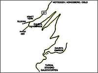
![Veikart]()
Getting there
Driving directions to the area: - Drive to Kongsberg.
- From Kongsberg you head for Geilo on national highway 40 ( Riksvei 40).
- Drive along on 40 for about 8 km.
- Turn off to national highway 37 towards Rjukan.
- Pass Bolkesjø and Gransherad and continue along Tinnsjøen (Tinn Lake).
- Just before arriving in Rjukan, look for signs saying Tuddal and turn left at the sign (you see a power station on the right).
- Continue following signs to Gaustablikk.
- At Svineroi (at a large red hut), you turn off to the right. You are now at the foot of Gaustatoppen.
Michelin's interactive site for driving information.
Google maps for the route from Kongsberg (as described above) Can be loaded onto your phone if you're using the GPS to get there!
Climbing Gaustatoppen

Summit view to the east
There is a path directly to the summit. Easy to find, as it is very well-traveled. It follows the east flank for about one hour. Then it turns left and continues in a lot of switchbacks up the southern pillar. It is neither very steep nor airy. Near the top is a hut that is manned in the season. It is possible to buy some snacks here. The summit is still half an hour away to the north. It gets a little more difficult near the summit, but it still just a walk-up, not a scramble. In foggy weather be a little careful near the summit. The trip takes about 3 hours up and 1-1.5 hour down.
There is a route from north-northwest which is somewhat steeper than the normal route and a bit more difficult in places. At one point it is an airy scramble.
Red Tape & Camping

Summit
No red tape, but consider the following.
In general, camping is allowed everywhere in Norway if you pitch the tent more than 200 meters from the cottages/hotels.
Common sense also goes a long way. It may be legal to camp in a certain place, but if it is too close to someone's house it is not really appropriate.
Some hut and hotel owners in Norway are trying to add local restrictions in order to stop camping too close to their hotels and huts.
These restrictions are probably illegal, but in order to have a pleasant time camping, it may be better to camp a bit away from the hotels and huts.
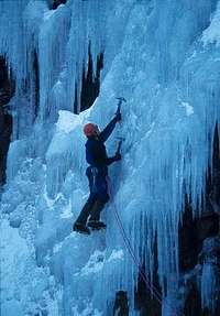
When To Climb
Ice climbing in the nearby Rjukan
May to September is the period when most people visit the area for hiking Gaustatoppen. The conditions on the mountain during the rest of the year, includes deep snow, hard winds and during mid-winter very short days. If you want to attempt the peak during the winter, gear up for really cold weather conditions.
The road to the parking lot is normally closed in winter, so the approach is very long. People still ski-climb Gaustatoppen from time to time. The normal approach for this is from the south.
It may be less popular to climb Gaustatoppen in the wintertime, but that is when the ice climbing season is in full swing. During the peak it may be hard to find accommodation in Rjukan.
Accommodation

West face
There is a hotel near the trailhead. It is called Gaustablikk.
The hotel´s website
A list of lodging in the area, mostly mountain huts and cottages.
In the village of Rjukan there are plenty of hotels/hostels.
Map
A simple map.
A map, showing roads and where Gaustatoppen is located.
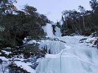
Ice Climbing in Rjukan
Ice climbing in Rjukan
Close to Gaustatoppen some of the world's best ice climbing areas is to be found. I choose to include some basic info on this page as there are nothing about this fascinating area on Summitpost yet.
- Ice season 2005/2006 All the info you need.
- An overview page about the area
- The tourist office of Rjukan.
- Download the ice climbing guide. Routes and information.
- Iceclimbing, an introduction to Rjukan
- Lots of photos of the frozen waterfalls in the area
- More about Rjukan. In German/Deutsch.
The peak's military history

NATO radio tower
There's a military installation on the summit of Gaustatoppen. After the end of the cold war, it was revealed that there's a lift inside the mountain taking supplies and personnel to the peak. It was a well-kept secret and came as a bit of a shock to the locals at the time. I don't have all the details but the entrance is supposedly at the bottom of the valley, with a lift in an angled shaft up to the summit.
Anyhow, Gaustatoppen is no longer of military significance and their plans to open it for tourists (which I hope won't happen).
This interesting piece of info was added by Erik S.
Miscellaneous Info
Puck adds the following information:
This area is wonderful in winter for ice climbing. There are many routes in the vicinity of Rjukan and it is possible to buy a guide book at the post office in the town center.
The cabins on the south side just as one enters the town from the east are inexpensive and comfortable and the owner maintains a drying room in the winter to accomodate ice climbers.
External Links
- Trip to Gaustatoppen August 2002
- The National Park of Gaustatoppen's site In Norwegian, but some cool video-clips from the summit and the rest of the mountain.
- Official tourist bureau website about the area.
- Skiing to Gaustatoppen
- Norway Tourist Guide (with hikes, travel tips etc.)