
-
 10079 Hits
-
 86.85% Score
-
 23 Votes
|
|
Mountain/Rock |
|---|---|
|
|
61.51694°N / 7.90730°E |
|
|
Sogn og Fjordane, Luster kommune |
|
|
Hiking, Mountaineering, Ice Climbing, Mixed |
|
|
Summer |
|
|
6785 ft / 2068 m |
|
|
Overview
Geographical classification: The Scandes > Jotunheimen > Fannaråken
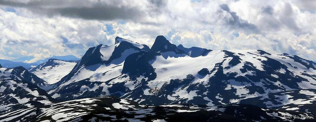
Fannaråken 2068 m
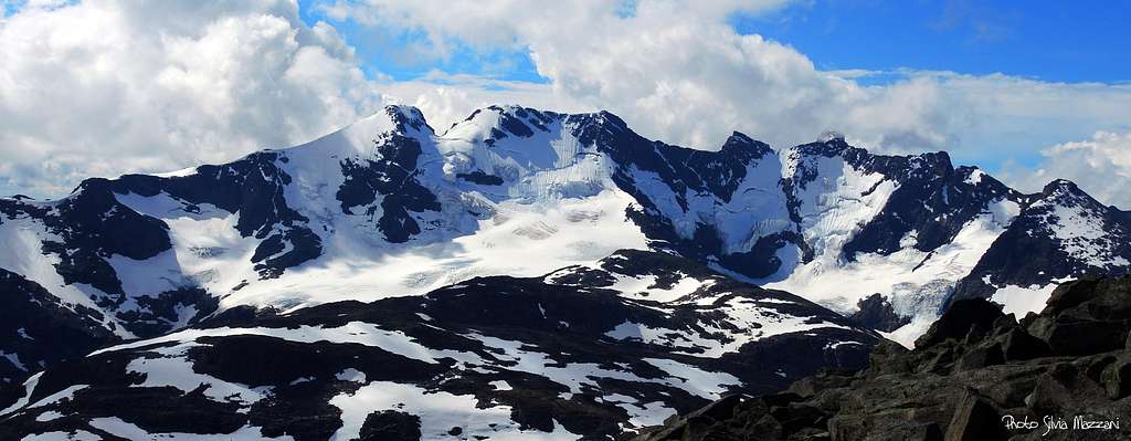
The Hurrungane Massif, located within the Jotunheimen National Park, is one of the finest mountain area in Norway and probably in the whole Scandinavia. The mountain range belongs to the municipalities Luster and Årdal in Vestland county and it's located to the SW in the larger Jotunheimen range. Sharp peaks and towering mountains project their high vertical walls above broad crevassed glaciers, falling down into extensive valleys. The Hurrungane Massif can be divided into two main groups, showing quite different features. The main massif is located in the South West, including the most challenging 2000er in the Scandes chain, as Store Skagastølstind. In the North-Eastern sector of the massif Hurrungane it's situated a smaller group, the nice Fannaråken group, including some beautiful mountains with gentler profiles, as Fannaråken 2068 m., one of the most famous summit in Norway and one of the most frequently attended.
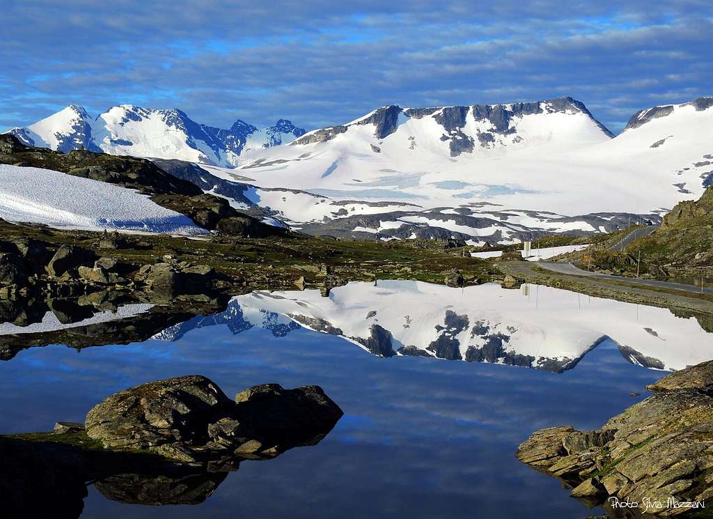
Its quaint and charming profile is perfectly in sight to who is driving along the beautiful Sognefjellsveien (Sognefjells road, Highway 55) and the eye can not help but be powerfully attracted to this view. Fannaråken has only one side heavily glaciated, in fact it has two completely different sides.
On the North side, towards the Sognefjell Road, its gentle sloping summit crest rises in spectacular fashion above the Fanaråkbreen glacier. On the contrary the scree-covered slopes on the South side drop down to the crags above the Illvatnet Lake in the valley. On the summit of Fannaråken there a Weather Station and a mountain lodge providing accommodation during the full summer (July and August).
Getting There
The starting point to climb the Fannaråkbreen Glacier route is the Sognefjellshytta lodge along the Sognefjellsveien Road (Highway 55), joining Turtagro and Lom. Obviously it can be reached both from Turtagrø, closest, and Lom.
Summit views
Fannaråkbreen route from Sognefjellshytta
Fannaråkbreen Glacier and Fannaråknosi Direct route report
Summit altitude: 2068 m
Difficulty: Alpine PD- a glacier crossing plus a steep ice-couloir
Vertical gain: 700 m
Exposure: North, then East
Starting point: Sognefjellshytta Lodge
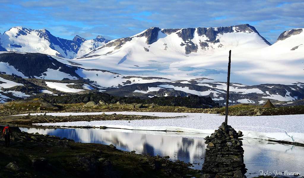
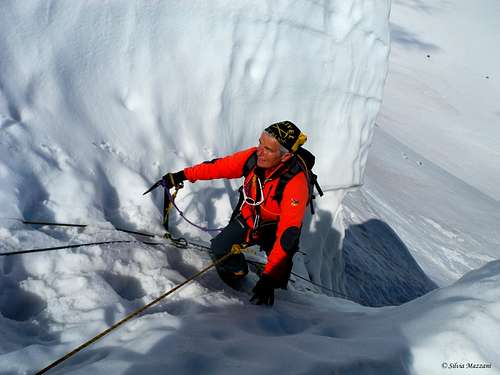
A worthwhile route for a great day enjoying breatktaking views all around over Jotunheimen and Hurrungane chains. It's an itinerary with alpine character, definitely the most rewarding to summit Fannaråken. At first following a good trail marked by cairns in summer, the itinerary reachs the edge of the Fannaråkbreen Glacier and crosses it. A short but technical stretch inside an ice-groove must be overcome to get the broad summit crest leading to the summit.


Route report
From Sognefjellshytta surround the Western end of the lake lying in front of the lodge and then head to South across the flat plateau. This trait is shared with the trail directed to Skogadalsbøen Hut. After about 1 and a half km there is a very well marked crossroad. Ignore the path to the left, leading to the Skogadalsbøen Hut, and take the right trail heading South-West. After about 10 minutes from the junction the trail crosses a stream, then it starts skirting at first the Eastern shore of Prestesteinvatnet lake, then the Southern one for about 4 km.


After a big cairn and a characteristic erratic boulder on the shore of the lake, the trail starts to veer southward, skirts another thin lake and overcomes across an iron bridge the brook exiting from the small lake. After a boulders area the trail gets the moraine and the edge of the glacier.


Rope up here because even though Fannaråkbreen may seem easy and without crevasses, actually deep water holes are sometimes hidden below the surface. The glacier is steep at first, then it levels off. Cross the glacier heading to the base of an obvious ice ridge on the left of the mountain, curving up rightward in the direction of the steep ice gully situated below Fannaråknosi 1990 m, at the left end (East) of the summit ridge. Climb up the ice ridge and then traverse right to get the base of the steep slope dropping down Fannaråknosi.

Overcome the steep but brief ice-gully - where during the full season there is usually a fixed rope - and exit on the summit edge. Once on the ridge the marked path from Skogadalsbøen lodge to Fannaråken joins from the South-West.


Take this trail rightward and follow it across the summit plateau for about 1 and a half km to get the Fannaråken cabin and the summit. During this final stretch, if the weather is poor and the visibility is reduced, be careful of large snow frames overhanging to the North. DNT Fannaråken cabin is situated just a few meters below the Fannaråken top at 2,069 meters above sea level. The view to Hurringane and the rest of Jotunheimen is superb.
- Variant to Fannaråkbreen Glacier route
This variant does not actually go up to Fannaråknosi, but ignores the slanting ice-ridge skirting round to the south side and reaches the summit ridge just to the west of it. Getting the base of the ridge it proceeds up the glacier to the East of this ridge to avoids the steep ice-couloir, to get the South ridge of Fannaråknosi itself.
Descent - You can reverse the same route or alternatively you can do the complete traverse, following the route to Turtagrø hotel, then take the bus to come back to Sognefjellshytta.
Essential gear
Full glacier gear (rope, axe and crampons); Prusik loops and ball-knot are also recommended
Other routes
Route Helgedalen - Fannaråken
Difficulty: walk
Vertical gain: 1050 m
Starting point: Turtagrø hotel 884 m
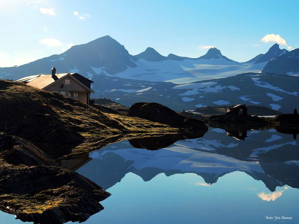
Locate the Turtagrø hotel 884 m on the west side of Sognefjells Road (highway 55) and park here, because the parking lot further on at the start of the walk is often full. Follow the Sognefjells road in the North-East direction (towards Lom) for 1 Km and exit right onto a gravel road entering the Helgedalen valley. After a few hundred meters, the road ends by a gate. It starts a "T" trail taking you into the Helgedalen valley. After about 2,7 Km., near the confluence of two streams, the road starts ascending. Follow the road for another 500 m, then turn to left at the signpost to Fannaråken. Follow the trail up to Ekrehytta hut. The trail then forks; the right trail heads to Skogadalsbøen, we follow the left trail rising directly to the summit of Fannaråken. Gradually the ground becomes rocky, the trail is strenuous, but it's a simple walking, there are no exposed stretches. Once on the ridge, you meet the "humps" taking you towards the summit. Cross the last snowfields leading towards the summit, a large, flat plateau with two buildings on the top. The primary building is Fannaråkshytta, it offers opportunities for food and sleep. The hut is operated by DNT (The Norwegian Mountain Touring Association).

- Route from Skogadalsbøen Hut
Skogadalsbøen Hut 830 m is a beautiful mountain lodge lying in the lush Utladalen valley. The hut can be approached both from Turtagrø and from Sognefjellshytta (shorter). The itinerary to the summit of Fannaråken begins from Skogadalsbøen and then leads you in the forest for some kilometers before it starts the mountain terrain. In Gjertvassdalen walk about 4 kilometer and passes then the lake Gjertvatnet.


After another kilometer you pass Keisarpasset and meet a snow field. The path goes uphill on more steep ground and finally reachs the broad Fannaråken summit ridge, along which to the top.
Red Tape

No particulary restrictions. Fannaråken is situated inside the superb Jotunheimen National Park, established in 1980, covering an area of 1150 square kms and including the 27 highest peaks in Norway. Jotunheimen is located between Oppland and Vestland counties and it's bordered by the great lake called Vågåvatnet, the valleys of Bøverdalen and Leirdalen and the road No. 55 (the mytical Sognefjellveg) to the N and NW, by the Road 51 to the East, by Bygdin, Tyin and Årdal to the South and by the mountain road between Årdal and Turtagrø to the West. More info : Visit Jotunheimen
Nature and climate
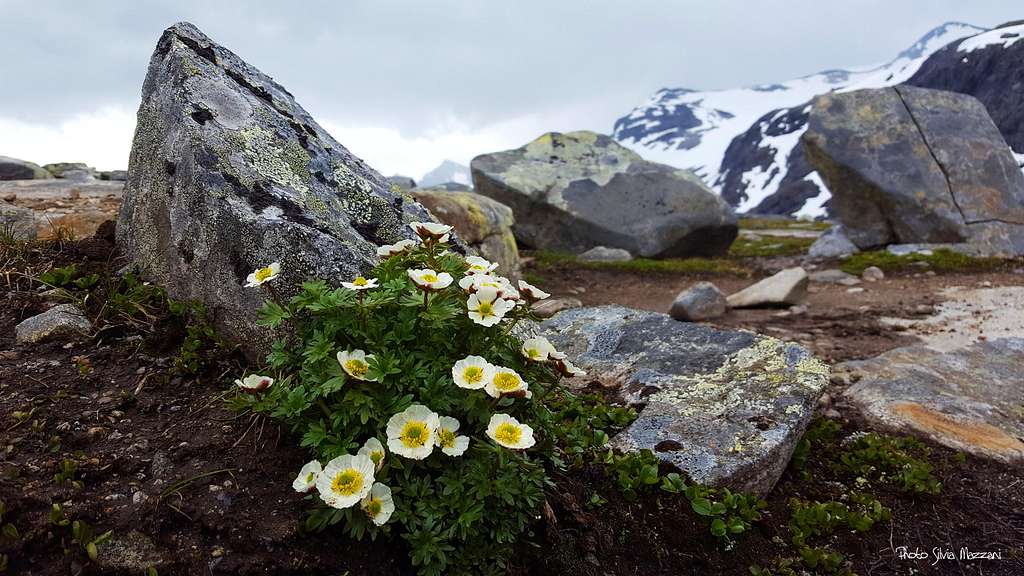
Jotunheimen is a wild area of majestic icecapped mountains, glaciers and wonderful lakes. Norway highest peak, Galdhøpiggen, lies within the National Park, together with the icecapped Glittertind, only a few metres lower. There are also several large lakes, amongst those the largest one is Gjende. Rapid weather changes can occur, lots of snow in winter due both to the latitude and the high altitude, nice summer with over up to 25 degrees Celsius with sunny weather. Be aware that at the highest altitudes deep snow can remain until mid summer. Mountaineering and hiking season varies, but usually they start in late June, being July and August the best months. In this area we can find the highest plants growing in Norway. The beautiful Glacier Crowfoot is the highest growing flowering plant, thriving at 2.370 metres on Glittertind, only 100 metres below the summit. Purple Saxifrage and Rose-root or Midsummer men also grow as high as 2.300 metres. Within Jotunheimen National Park we can find a rich variety of lime-loving plants, such as the Mountain Avens and other species, such as Hairy Stonecrop and Red Alpine Catchfly.
When to climb
Mountaineering - The best period to climb goes from the end of June to middle September.
Ski-mountaineering - This route is a classic in the spring on skis when much of the problems posed by crevasses are still covered
After late May however you will have to be wary of crevasses. The large cornices along the north side of the summit ridge are in constant danger of falling throughout spring and this area of the glacier below them should also be avoided.
Where to stay
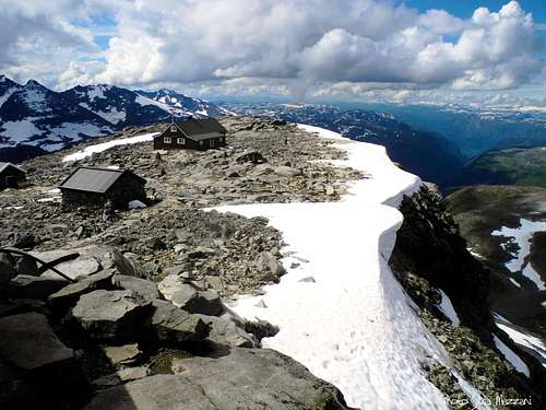
The Fannaråkenhytta on the summit
- Sognefjellshytta Lodge
Situation: Sognefjellsveien Road (Highway 55), joining Turtagro and Lom
Open: Easter until mid-September
Phone: +47 61 21 29 34
E-mail: post@sognefjellet.no
- Fannarakhytta on the summit, the highest overnight lodge in Norway
- Skogadalsbøen 833 m - Staffed DNT lodge with 87 beds
Situation: Utladalen valley
Open: Easter until mid-September
Phone: 97 56 90 94
Home page: http://www.skogadalsboen.com E-mail: k-hjell@frisurf.no
Map


Meteo
Sognefjellshytta weather forecast
Guidebooks and maps


- Guidebooks
"Walks and scrambles in Norway" Anthony Dyer - John Baddeley - Ian H. Robertson - Hiking, Scrambling and Mountaineering in Norway, Ripping Yarns 2006
"Opptur Jotunheimen" Finn Loftesnes - 125 selected itinerary on Jotunheimen - Selja Forlag 2009
- Maps
Jotunheimen Vest Turkart 2505" Scale 1:50.000
External Links
Visit Jotunheimen
Scandinavian Mountains
Norwegian Mountains
Jotunheimen
D.N.T. Den Norske Turistforening