
-
 15516 Hits
-
 84.82% Score
-
 19 Votes
|
|
Mountain/Rock |
|---|---|
|
|
48.13185°N / 121.57894°W |
|
|
Scrambling |
|
|
Spring, Summer, Fall, Winter |
|
|
5440 ft / 1658 m |
|
|
Helena Peak 5,440'
Distance: 7.0 miles R/T
Summit Elevation: 5,440'
Starting Elevation: 3,100'
Elevation Gain: 2,340'
Prominence: 1,000'
Rating: Class 3 Scramble
![Rotten Gully Scramble]() Scramble To The Summit
Scramble To The Summit ![Helena Peak]() Helena Peak Southwest Face
Helena Peak Southwest Face
This isn't to say Helena has not seen busier, more popular days. In the late 1800's this peak saw a lot of action on its southwest slopes. Helena is approximately 3.5 miles north of the small mining town of Silverton and was named after the Helena Mines. In short, Helena got its name from the old Helena claims that were discovered in 1892 by Montana prospectors. The currently accessible mines are located roughly between 4,500’ to 4,850’ in elevation on the southern-west ridge. The lower mine around 4,500’ is large and looks like you could go a long way inside, even though that is not encouraged and is full of water. The other mine is farther up around 4,850’ and is pretty shallow. If a person spent some time searching around, I’m sure they could find some interesting artifacts. Mines can be dangerous for a number of reasons so be careful and treat the area with respect. The history up there is still alive and you can feel the dreams, mystery, joys and disappointments from ages ago.
![Helena Mine Adit]() Entrance to the lower Helena Mine
Entrance to the lower Helena Mine
Not only does the history make this an interesting peak to visit, but also the challenge to gain the summit views. This peak can be climbed in a single day and in the summer months the summit can be reached in about 3-5 hours. If the Deer Creek Road is gated, plan on making a long road hike or snowshoe from the Mountain Loop Highway. Check road and trail conditions before you head out.
Helena is positioned in a location that offers amazing views of many classic Mountain Loop Highway peaks. Some of the most memorable views are looking west toward Liberty Mountain, Three Fingers and Whitehorse. I have to say that it has one of the best views of Three Fingers famous East face.
![Helena Peak Summit]() Helena Peak Summit
Helena Peak Summit
![Helena Peak 360° View]() Summit Panorama
Summit Panorama
![Whitehorse Mountain East Face]() Whitehorse East Face
Whitehorse East Face![Three Fingers East Face]() Three Fingers East Face
Three Fingers East Face
![Helena South Ridge]() Scrambling On Helena
Scrambling On Helena
The Route “Simplified”...
The approach is from the Kelcema Lake Trailhead which is at the end of the Deer Creek Road. The route follows the old Deer Creek Pass Trail for about a mile and then takes a right on the Helena mines trail. The trail is heavily flagged with many different colors of ribbon. It’s a faint trail that does not get many visits.
The trail traverses through dense forest, crosses a large talus slope below Helena’s southeast ridge and then switchbacks to where an old mine is located (4,500’). Right now there is an old, rusty wheel leaning on a tree at this spot. From here the trail ends and the goal is to go straight up (east) to the saddle. From the saddle you will want to skirt around to the east side of the ridge.
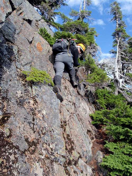
Basically you want to always be on the ridge or just off to the east slope. This depends a lot on how comfortable you are with exposure. From the saddle (4,900’) the goal is to head north along the ridge for a total of about 500’ of class 2 and 3 scrambling. There are some sections that can be dangerous if wet or if you don’t check the rock. Some of the rock can be very loose.
There is a false summit to skirt/climb around along the ridge. There is a good ramp that you can traverse all the way to some alpine trees about 100’ below the ridge on the east side. Once you get to the scrub trees you will need to up climb about 8’ of vertical slab with exposure and then make your way north from there.
Once around this obstacle there is a downsloping ledge that you skirt along carefully until you come to an 8’ cliff with a steep gully below. You have to down climb this, which requires a more physical move. Once down on a small, gravely ledge you continue north on ledges of heather and downsloping, loose slabs. There is no trail so you have a variety of options. You basically want to stay as high to the ridge as you feel safe with. You end at a loose, dirty gully that takes you up to the summit. This is a very steep section. Some people go up the center of the gully. Staying to the right you will find more solid rock and also some hemlock belays if they are needed. The register is in a Gatorade bottle and I put a new pen/pencil inside. To get a more detailed route page, click on this Southwest Ridge Route page or find it on the left column. This will show pictures along with much more detail.
![The Final Gully]() The Final Gully To The Summit
The Final Gully To The Summit
![East Slopes]() Downclimbing with exposure on the east slopes
Downclimbing with exposure on the east slopes
Getting there from the south on I-5:
In Everett, exit east onto US-2 via exit #194. Continue on US-2 for 2.2 miles (long elevated highway) until you arrive at WA-204, merge onto 204 going east toward Lake Stevens. Continue on 204 for 2.6 mi. until you arrive at Hwy 9. Turn left (North) onto highway 9, and travel 1.7 miles until you get to Hwy 92, and turn right (east) onto Hwy 92 (a.k.a. Granite Falls Highway). Continue on Hwy 92 for about 8 miles when you will arrive at Granite Falls. From Granite Falls, you will turn left onto Mountain Loop Highway at the major intersection at the other end of town. Drive Mountain Loop Highway for 23.5 miles to Deer Creek Road #4052 and take a left.
Getting there from the north on I-5:
Drive I-5 south to WA-531 and exit east on exit #206 toward Lakewood / Smokey PT. Continue for 3.5 mi. to Hwy 9 and turn right (south) on Hwy 9. Drive for 5.5 mi. to Getchell Rd. / 84th St. NE. Turn left (east) here and continue 4.6 mi. to Granite Falls Highway / Hwy 92. Turn left here and the remainder of the trip will be the same as above from Hwy 92.
Once you get to Deer Creek Road if the gate is closed you will have to park and walk in from there. If it is open you can drive to Kelcema Lake Trailhead. This is the large, gravel turnout at basically the end of the road.
![Helena Peak Topo]() Helena Topo
Helena Topo
Local Weather Forecast at Helena Peak
Northwest Weathe & Avalanche Center
Distance: 7.0 miles R/T
Summit Elevation: 5,440'
Starting Elevation: 3,100'
Elevation Gain: 2,340'
Prominence: 1,000'
Rating: Class 3 Scramble
 Scramble To The Summit
 Helena Peak Southwest Face
Overview
Helena Peak is a rugged, reddish peak that has an impressive 1,000 feet of prominence and offers a great scramble. Most people do not know much about Helena because of its remote location. It isn't visible from any major roads and is surrounded with miles of large, dense forests. It’s a very secluded area for only being a short distance north of Mountain Loop Highway .This isn't to say Helena has not seen busier, more popular days. In the late 1800's this peak saw a lot of action on its southwest slopes. Helena is approximately 3.5 miles north of the small mining town of Silverton and was named after the Helena Mines. In short, Helena got its name from the old Helena claims that were discovered in 1892 by Montana prospectors. The currently accessible mines are located roughly between 4,500’ to 4,850’ in elevation on the southern-west ridge. The lower mine around 4,500’ is large and looks like you could go a long way inside, even though that is not encouraged and is full of water. The other mine is farther up around 4,850’ and is pretty shallow. If a person spent some time searching around, I’m sure they could find some interesting artifacts. Mines can be dangerous for a number of reasons so be careful and treat the area with respect. The history up there is still alive and you can feel the dreams, mystery, joys and disappointments from ages ago.
 Entrance to the lower Helena Mine
Not only does the history make this an interesting peak to visit, but also the challenge to gain the summit views. This peak can be climbed in a single day and in the summer months the summit can be reached in about 3-5 hours. If the Deer Creek Road is gated, plan on making a long road hike or snowshoe from the Mountain Loop Highway. Check road and trail conditions before you head out.
Helena is positioned in a location that offers amazing views of many classic Mountain Loop Highway peaks. Some of the most memorable views are looking west toward Liberty Mountain, Three Fingers and Whitehorse. I have to say that it has one of the best views of Three Fingers famous East face.
 Helena Peak Summit
 Summit Panorama
 Whitehorse East Face
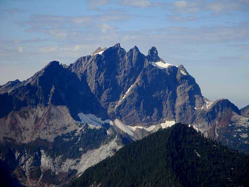 Three Fingers East Face
The Route "Simplified"
 Scrambling On Helena
The Route “Simplified”...
The approach is from the Kelcema Lake Trailhead which is at the end of the Deer Creek Road. The route follows the old Deer Creek Pass Trail for about a mile and then takes a right on the Helena mines trail. The trail is heavily flagged with many different colors of ribbon. It’s a faint trail that does not get many visits.
The trail traverses through dense forest, crosses a large talus slope below Helena’s southeast ridge and then switchbacks to where an old mine is located (4,500’). Right now there is an old, rusty wheel leaning on a tree at this spot. From here the trail ends and the goal is to go straight up (east) to the saddle. From the saddle you will want to skirt around to the east side of the ridge.
Basically you want to always be on the ridge or just off to the east slope. This depends a lot on how comfortable you are with exposure. From the saddle (4,900’) the goal is to head north along the ridge for a total of about 500’ of class 2 and 3 scrambling. There are some sections that can be dangerous if wet or if you don’t check the rock. Some of the rock can be very loose.
There is a false summit to skirt/climb around along the ridge. There is a good ramp that you can traverse all the way to some alpine trees about 100’ below the ridge on the east side. Once you get to the scrub trees you will need to up climb about 8’ of vertical slab with exposure and then make your way north from there.
Once around this obstacle there is a downsloping ledge that you skirt along carefully until you come to an 8’ cliff with a steep gully below. You have to down climb this, which requires a more physical move. Once down on a small, gravely ledge you continue north on ledges of heather and downsloping, loose slabs. There is no trail so you have a variety of options. You basically want to stay as high to the ridge as you feel safe with. You end at a loose, dirty gully that takes you up to the summit. This is a very steep section. Some people go up the center of the gully. Staying to the right you will find more solid rock and also some hemlock belays if they are needed. The register is in a Gatorade bottle and I put a new pen/pencil inside. To get a more detailed route page, click on this Southwest Ridge Route page or find it on the left column. This will show pictures along with much more detail.
 The Final Gully To The Summit
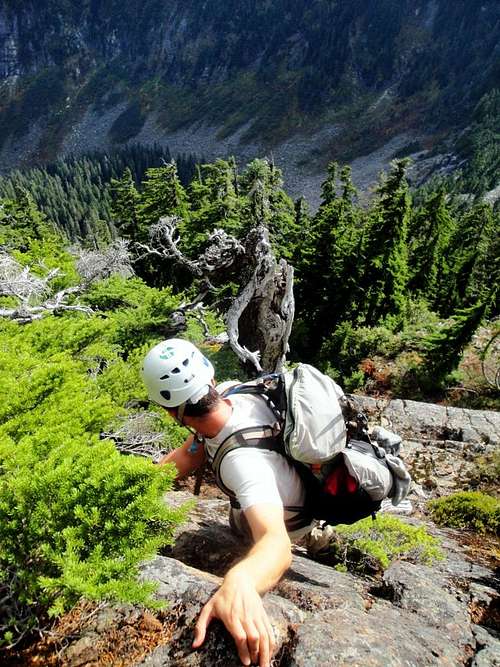 Downclimbing with exposure on the east slopes
Getting There
From Granite Falls follow the Mountain Loop Highway east 23.5 miles to Deer Creek Road.Getting there from the south on I-5:
In Everett, exit east onto US-2 via exit #194. Continue on US-2 for 2.2 miles (long elevated highway) until you arrive at WA-204, merge onto 204 going east toward Lake Stevens. Continue on 204 for 2.6 mi. until you arrive at Hwy 9. Turn left (North) onto highway 9, and travel 1.7 miles until you get to Hwy 92, and turn right (east) onto Hwy 92 (a.k.a. Granite Falls Highway). Continue on Hwy 92 for about 8 miles when you will arrive at Granite Falls. From Granite Falls, you will turn left onto Mountain Loop Highway at the major intersection at the other end of town. Drive Mountain Loop Highway for 23.5 miles to Deer Creek Road #4052 and take a left.
Getting there from the north on I-5:
Drive I-5 south to WA-531 and exit east on exit #206 toward Lakewood / Smokey PT. Continue for 3.5 mi. to Hwy 9 and turn right (south) on Hwy 9. Drive for 5.5 mi. to Getchell Rd. / 84th St. NE. Turn left (east) here and continue 4.6 mi. to Granite Falls Highway / Hwy 92. Turn left here and the remainder of the trip will be the same as above from Hwy 92.
Once you get to Deer Creek Road if the gate is closed you will have to park and walk in from there. If it is open you can drive to Kelcema Lake Trailhead. This is the large, gravel turnout at basically the end of the road.
 Helena Topo
Externals Links
Forest Service Road and Trail ConditionsLocal Weather Forecast at Helena Peak
Northwest Weathe & Avalanche Center
chandlerhaberlack - Jul 25, 2017 1:01 am - Hasn't voted
roads washed outtrip is now a an additional 3k feet of gain with 4+ miles rt
Athanasius - Jul 30, 2018 10:59 am - Hasn't voted
Road Washed OutThe road is now completely impassible by any vehicle past 2mi. It would be difficult to get a normal car further than about 1.5 mi. With the decreased usage I am afraid that the trail to the mines will be nearly impossible to follow in a year or two.