
|
|
Mountain/Rock |
|---|---|
|
|
48.04095°N / 121.1529°W |
|
|
Snohomish/Chelan |
|
|
Hiking, Mountaineering |
|
|
Spring, Summer, Fall |
|
|
7043 ft / 2147 m |
|
|
Overview
White Mountain is a peak located in Glacier Peak Wilderness, on the border of Snohomish County and Chelan County in Washington. As the most dominant peak on the ridge between Red Pass to White Pass, White Mountain has an advantageous central location. The summit of White Mountain also offers quite possibly the best overall views than any other mountain of the standard southern summit routes for nearby Glacier Peak.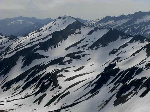 The Northwest Side Of White Mountain
The mountain has steep stopes, yet the two standard approaches are non-technical when snow is not present. The shortest, and most common, approach is from White Pass located to the south. Another approach is from Red Pass located to the west. It is also feasible to summit the mountain via its north slope or northeast ridges, but the two previous standard approaches mentioned already have established unofficial boot paths.
 The South Side Of White Mountain, Glacier Peak In Background
White Mountain has long been a favorite destination of outdoor enthusiasts. The peak is centrally located between other popular summit destinations such as Glacier Peak, Portal Peak, and Indian Head Mountain. The mountain, with its heather and talus slopes, as well as its proximity to the Pacific Crest Trail (PCT), has also been a picturesque peak to take photos both of and from. The peak has also been known as a good location to find small garnets in schist exposed on its ridges.
Standard Summit Routes
FROM WHITE PASS (5904' elevation):
1) Very briefly head north on a well-established trail, as if to side-traverse along the lower east slopes of White Mountain.
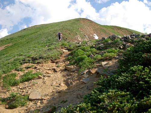
2) Immediately after passing where White Mountain's south ridge meets White Pass, begin steeply hiking uphill along the ridgeline at a bare ground area.
3) Within ~100' of elevation gain, an established boot path is reached, which leads up the south ridge for the remainder of the hike.
 Ascending South Ridge...
4) At ~6500' elevation, a small cliff band and grove of evergreen trees are intersected along the ridgeline, and the boot path appears to disappear. Head left (west) around that section and re-attain the boot path on the other side.
 Ascending South Ridge Above 6500'...
5) Continue following the boot path to the flat linear summit (7043'), finding numerous marmot holes along the way.
 White Mountain Summit
ONE-WAY HIKING DISTANCE FROM WHITE PASS: 0.75 miles, with 1139' elevation gain.
FROM RED PASS (6460' elevation):
1) Starting from Red Pass, there are two immediate choices: steeply ascend east along a boot path leading directly over Point 6634, or temporarily follow the PCT south-southeast around Point 6634. Due to the cliff bands and thick groves of evergreen trees on Point 6634, the latter option is recommended and will be described here.
2) From Red Pass, follow the PCT south, then southeast, around the first unnamed highpoint along the ridge: Point 6634.
3) Once beyond Point 6634, the PCT is briefly only ~50' elevation below the ridgetop. Ascend northeast to the ridgetop.
4) Once on the ridgetop, a boot path is attained. The boot path occasionally is overgrown and seems to disappear, but the route approach is straightforward: just continue heading east along the ridgetop.
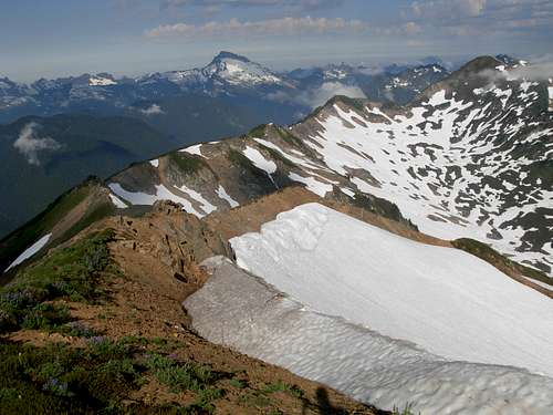 West Ridge Traverse Between White Mountain And Red Pass
5) Several minor bumps are encountered along the ridgetop but none of them are difficult to traverse.
 One Of Minor Bumps Between White Mountain And Red Pass
6) Continue following the boot path to the flat linear summit (7043') of White Mountain.
 USGS Summit Benchmark
ONE-WAY HIKING DISTANCE: 1.75 miles, with ~600' of elevation gain.
Getting There
DRIVING DIRECTIONS:
1) From the town of Darrington, drive approximately 16 miles south along the Mountain Loop Highway.
2) Turn left onto Forest Road 49, also known as North Fork Sauk River Road.
NOTE: This road might be unmarked, so for location/reference purposes it is the second major forest road found on the left (east) side of the Mountain Loop Highway after passing the marked road that leads to the Mount Pugh trailhead.
3) Drive 6.7 miles along Forest Road 49, until a "Y" intersection.
4) At the "Y" intersection, turn left. Follow for 0.7 miles to the trailhead for North Fork Sauk Trail #149.
HIKING DIRECTIONS:
1) From the trailhead (2072') for North Sauk Trail #149, follow the trail east.
2) White Pass is 8.9 miles one-way from the trailhead, or Red Pass is 9.9 miles from the trailhead.
Red Tape
A Northwest Forest Pass is required if parking a vehicle at the trailhead for North Fork Sauk Trail #149.There are no rules or restrictions to climb White Mountain.
There are no water sources along the standard approaches of White Mountain, although some small streams fed by snowmelt can be found passing across the PCT along lower south slopes of the mountain from Spring through mid-Summer.