
-
 48848 Hits
-
 89.68% Score
-
 31 Votes
|
|
Mountain/Rock |
|---|---|
|
|
48.09890°N / 121.4433°W |
|
|
Hiking, Scrambling |
|
|
Summer, Fall |
|
|
6005 ft / 1830 m |
|
|
Overview

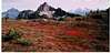
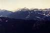
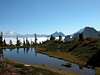
Located along the scenic Mountain Loop Highway in the North Cascades, Mt. Forgotten lays hidden among the surrounding craggy peaks of the North/Central Cascades in Washington state.
This area of the North Cascades is unique as it gets almost the same amount of rainfall as the Olympic Mountains (up to 140 inches) which makes for some dense forests and many small ponds and tarns. The area was originally developed when gold and silver were discovered but a few years later in the 1890's that boom was over and the area was then developed for rich Seattle tourists. That dried up when the stock market crashed.
The hike up Mount Forgotten is a nice hike that will take you most of the day. Round trip it is 14.5 miles with almost 4300 feet of gain. Forgotten itself has a prominence of 2725 feet. It is a Class 3 scramble from the meadows to the summit, loose in spots. The hike starts through a valley with Big Four Mountain at the southern end. Most dayhikers with families stop at the falls but many continue on to the meadows which are itself a great goal. The amazing views of the summit rocks and the surrounding mountains are worth that alone. And in late summer, the area is full of blueberries and huckleberries which are plundered by hikers. The hike over to the summit begins with a loose downclimb and traverses the east side of the summit rocks to a tarn on the NE corner. From there you ascend a gully to the summit. The true summit is the middle of the three points though most stop at the north one. There is some serious exposure over to the true summit.
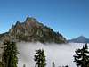
Beckey states that early settlers called Mt. Forgotten the "Lady of the Mountains" because it resembled a hooded woman. The rock is volcanic breccia which is cut by dikes. It is a fairly popular hike although probably 90% stop in the meadows and do not complete the scramble to the actual summit.
 |  |  |  |  |
Getting There
I-5 to Highway 2 east to Highway 9 north to State Route 92 (Mountain Loop Road) to Granite Falls and follow the Mountain Loop Roop east (it's a left at the east end of town) past the Public Service Center in Verlot 16.3 miles (you can also stop at the Verlot Ranger Station to inquire about trail conditions) to a large trailhead parking on the left for Mt. Dickerman. (If coming from Darrington, take Mountain Loop Road (Forest Road 20) south 23.5 miles to Barlow Pass, then west a couple miles to the trailhead.)Please note that these directions and trailhead are new as of 2009 as the road to the trailhead from Perry Creek Campground has now been closed. A connector trail over to the Perry Creek Route has added 1.5 miles each way and 300 feet to the old route. (Link to information.) Please be aware of this if you are also going by a guide book that is older than 2009.
 |  |  |  |
Red Tape
Northwest Forest Pass required at trailhead.When To Climb
This hike is best done in summer or early fall. For adventuresome folks, go in the dead of winter for a fun approach.Blueberries and huckleberries abound just before the meadows in late summer.
 |
Camping
Perry Creek Campground on Mountain Loop Highway. Could also camp in the meadows.Mountain Conditions
Verlot Ranger Station (staffed in summer), (360) 691-779133515 Mountain Loop Highway
Granite Falls, WA 98252
Darrington Ranger District
360-436-1155
Link for Road Conditions
 |  |  |  |
External Links
- Mount Forgotten Pictures from IBEXtrax.com
Numerous pictures and map of the Mount Forgotten area.
- Mt. Forgotten Meadows Pictures
Pictures from WashingtonHikes.com .
- Perry Creek/Mt. Forgotten Trail No. 711
Trail description from the Seattle Post-Intelligencer newspaper website.
- Perry Creek Trail Description
From the Seattle Post-Intelligencer newspaper.
- Mt. Forgotten Trail to Perry Creek Falls
Trip report from June 29, 2002 with lots of pictures.
Klenke - Nov 4, 2002 8:00 pm - Voted 10/10
Untitled CommentTo get to the true summit point, which is about 50 feet west of the end-of-trail lesser east point, requires the ability to climb a wickedly exposed 10-foot section of class 3+ knife-edge rock. In my opinion it's actually class 4 due to the level of exposure--both to the left and the right. Plus, it's harder to get back down it than to climb up it. You definitely want to beware of this.
gimpilator - May 14, 2007 12:04 am - Voted 10/10
Access Road UpdateAs of 5/13/07 There are several trees blocking the road about 1/4 mile from the mountain loop highway. This adds about 3/4 mile on to the approach. I expect they'll have the road cleared by June or July.
tjmcnitt - Sep 30, 2008 6:59 pm - Hasn't voted
Perry Creek Road to be permanently closedThe Forest Service announced today, 9/29/08, that the Perry Creek Road is to be permanently closed. Their plan is to expand parking at the Mt. Dickerman trailhead and build a connector trail from there to the Perry Creek Trail. I just confirmed with the Forest Service that the change will add 3 miles round trip to the trail. That means the long 11.5 mile day hike to the summit of Mount Forgotten will soon be a 14.5 mile overnight.
Cascade Scrambler - Oct 1, 2010 9:29 pm - Voted 10/10
Perry Creek Road now closedMight want to update the mileage and "getting there" section as tjmcnitt sugggested- with Perry Creek Road now closed, it's 14.5 miles round trip. The new trail from the Dickerman TH to the old TH is super easy and goes by quickly.
Brian Jenkins - Oct 4, 2010 12:53 pm - Hasn't voted
Re: Perry Creek Road now closedThanks, will do. Must have missed tjmcnitt's post previously. Thanks. Brian
Dundeel - Sep 16, 2012 11:49 am - Hasn't voted
True SummitOn 9/15/12, our group, with Greg Slayden, Bob Bolton, Dennis Poulin, Eric Noel, Edward Earl, and myself, determined that the first point is the highest. We sighted through the first and second points and the line of sight was well below the summit of Mount Pilchuck (5340 ft). This could only be true if the line of sight is downsloping. In addition we strung a line between the two points and the lowest point of the catenary was definitely closer to the second point, once again indicating the second point is lower. A water bottle on its side was used to help visualize level. Some of the top rocks on the second point appeared to be freshly exposed, so it's possible that lightning or someone has modified the second point to reduce its height. At this point, there is no need to scramble the second point to claim this summit. Ken Russell