
-
 15895 Hits
-
 76.37% Score
-
 7 Votes
|
|
Mountain/Rock |
|---|---|
|
|
48.22049°N / 121.32259°W |
|
|
5983 ft / 1824 m |
|
|
Overview

The Summit Block
Circle peak is a minor pointed summit 12 east of the town of Darrington. It was formerly the location of a fire lookout, from the years of 1935-1967. Many pieces of broken glass, now melted by lightning strikes can be found scattered about on the flattened summit platform. Originally the trail was 20 miles round-trip coming up all the way from the valley floor. Logging was extensive in this area during the 1960's. Thanks to logging roads, the trail is now only 4 miles round-trip.
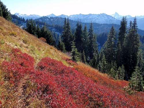
Fall Colors On The Upper Slopes
Circle Peak has never been a popular hike and has traditionally seen few visitors in any give year. This number dropped even further in 2003 when seven inches of rain fell in a 24 hour period. The washouts and road closures instantly became an obstacle which lasted for the next 7 years. Boundary Bridge was completely destroyed but has recently been rebuilt in 2010.

White Chuck And Whitehorse Seen From The Summit
So what is the draw? Well you won't find another hike in the Darrington area where you have the whole mountain to yourself. There are several meadows to explore, a creek, and ancient trail works. Find puncheon bridges in various state of decay. Look for old insulators on trees where the telephone line ran to the lookout. Find treasures below the summit, thrown there by generations past. This peak also offers the best views available of White Chuck Mountain's east face. Glacier Peak is also nearby and impressive as ever. Dome Peak, Mount Buckindy and Mount Misch are also looking good from this vantage.
Getting There

Dome Peak Seen From The Summit
From Darrington, drive north on 530 for 7.5 miles. Right after crossing a large bridge, turn right on Suattle River Road. Follow this for 9.8 miles to a right-hand junction where the odd metallic Boundary Bridge structure crosses the Suattle River. This is National Forest Road 25. Follow this for approximately 3 miles until it come to a Y junction. Turn right onto National Forest Road 27 and begin driving uphill. After 1.5 miles and a couple of tight turns, there is one last junction. Keep to the left on Road 2703 and continue another mile to the large parking area where a pile of boulders blocks any further motorized travel.

Glacier Peak Seen From The Summit
To get to the actual trailhead requires a mountain bike, plenty of fortitude, and a burning desire to be completely alone. From the parking area it's approximately 5 miles to the end of the road. The road is in good condition and it's hard to understand why it's closed to motorized traffic. After several switchbacks (be sure to avoid smaller spur roads), the road comes to a dead end where there is a large pile of logs. On the right side of the road is steep open brushy slope. The trail cuts across this slope but it is not visible from the road. To reach the trail one must make a short bushwhack straight uphill until intersecting the trail.

The False Summit
Once on the trail, start out by heading east. Cross some old decaying bridges and enter a couple of open meadows. A few switchbacks will lead to the top of the ridge where if you look carefully you may catch a glimpse of Indigo Lake. The trail continues north to the false summit. Some old guide books have made the claim that the scramble over to the true summit and site of the lookout is too dangerous and should not be attempted. This is simply not true. It's short and easy.
Red Tape
For once, no Northwest Forest Pass is required at the abandoned trailhead.When To Climb
The best time is July for flowers, and September for huckleberries. There are plenty of surrounding lakes for off-trail exploration. The fishing opportunities at Indigo, Crystal, Meadow, Emerald and Diamond lakes are a mystery to be explored.Camping
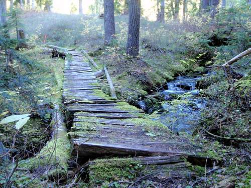
Old Trail Work
It's so short, there is not much reason to stay at Circle Peak. If you want to camp, there are plenty of hidden places near meadows with running water. The top is fairly flat, having once housed a lookout. There is a spring located a few hundred feet below the summit. Where the trail crosses the ridge (5600') follow a way path right and down. About 200' below the ridge you will find water. You can also continue down another 800' to Indigo Lake.
Mountain Conditions
Darrington Ranger District: 360-436-1155Go here for fresh reports from wta.org
Here is a Darrington weather forecast
Here is a Darrington webcam
Here is Darrington, Washington's town site
External Links
A special thanks to Magellan for showing me the route and allowing me to refurbish this page.