
-
 6287 Hits
-
 77.48% Score
-
 8 Votes
|
|
Mountain/Rock |
|---|---|
|
|
43.13754°N / 109.66144°W |
|
|
Hiking, Mountaineering, Trad Climbing, Scrambling |
|
|
Spring, Summer, Fall |
|
|
13115 ft / 3997 m |
|
|
Overview
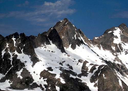
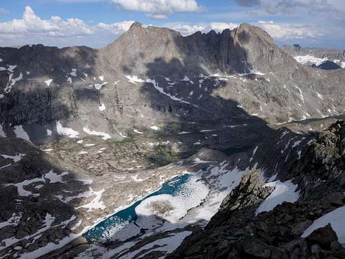
Henderson Peak is another commonly overlooked peak sitting directly above and west of the ever popular Titcomb Basin. It's one of the 35 Wyoming 13ers, and sits right at the heart of the core wind rivers, of which 10 of them encircle Titcomb Basin (see the list here). With a base camp in upper Titcomb Basin, you could spend days climbing and scrambling 13ers, or working through technical routes on nearby Mount Helen, Sacajawea, Spearhead or Woodrow Wilson, of which Helen offering the best technical objectives with rock climbing routes as high as 5.11 which are briefly described on that mountain page. Henderson Peak itself even offers some good technical objectives, and the rock on this mountain is substantially better than American Legion Peak just to the north.
Getting There
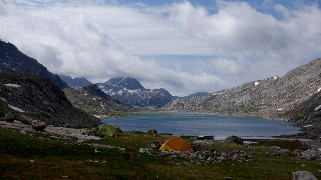
Use the Elkhart Park Trailhead accessed from Pinedale on the west side of the range and hike the Pole Creek Trail to Island Lake, passing by Photographers Point and Seneca Lake along the way. Just after passing over a small divide at 10,660 feet Island Lake will come into view. Descend to it and continue to the junction with the Titcomb and Indian Basin trails. Take the Titcomb Basin Trail heading north/leftward and hike past Lower and Upper Titcomb Lakes as the trail follows along their east shores. Base camp can be set up about 0.5 mile past the upper lake where many rock shelters have been built by Gannett Peak climbers and other backpackers.
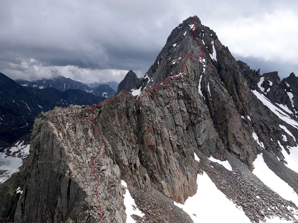
Route - North Ridge Class 4
The north ridge is the easiest, and one of the best scrambles in the entire mountain range. The Joe Kelsey guidebook says it's an instant classic and I would not disagree. Routefinding on this route can be difficult, and involves a lot of crossing back and forth on both sides of the ridge crest, but I have spelled out the easiest line below. You can easily make this climb much harder if you choose by staying on the crest more and the rock is generally superb.
From upper Titcomb Basin at the typical camping spot 0.5 mile past the upper lake at 10800 feet elevation, the first obstacle is crossing the river draining down into the lakes. I managed to find some boulders to hop across by walking further north, but if it's before August most people will want to wade across. In earlier season before mid July snow bridges over the creek will likely be easy to find. Once across, continue west traversing just below a large buldefield, and ascend to the crest of the small south ridge coming off Point 12205, reaching it at a small gentle notch at 11,330 feet.
Once you reach this ridge, a gorgeous view of Summer Ice Lake greets you below. This lake remains frozen well into July each year. Make a gentle descending traverse to the NW into the upper basin above Summer Ice Lake, and then ascend snow slopes to the 12,300 foot saddle between American Legion and Henderson Peaks. The snow reaches 40 degrees in seepness on the upper part of this slope so crampons are advisable. Spikes likely won't be enough unless it's real soft. From this saddle, to climb the north ridge, cross over to the west side a few feet and bypass the initial gendarmes on the ridgecrest to the west side just below them, and continue on a ledge system until you reach the base of a 4th class gully/dihedral seam that you climb to reach the ridgecrest again. This is one of the cruxes of the route.
Once back on the crest, follow it as it narrows and reaches a large bouldery slab blocking easy passage on the ridge. Here, you can can crawl through a tunnel to go under this obstacle. I actually climbed over this which has a slightly overhanging start doing a low 5th class move, or you can traverse west (right) around it on the slabs (exposed class 4+), but if you find the tunnel that's the easiest option. Beyond this obstacle, the ridge makes a short jog to the west where you have to downclimb a 15 foot Class 4 step down slightly on the east side to get around a small tower and notch.
Past this the ridge begins to steepen, and you'll reach a point where it steepens considerably into a knife edge. Traverse out onto the east side here and connect a series of Class 3 ascending ledges with some mild exposure. Once you're beyond the knife edge section, locate a ledge that cuts back to the south and allows easy access back to the crest, where you then cross it to the west side again. A series of Class 3-4 ledges and short slabby upclimbs to the west of the crest brings you to a large ledge that then dumps you into a more open and much less exposed class 2 talus slope on the upper part of the mountain. Ascend this talus to a small notch back on the crest, then cross back to the east side and traverse the top edge of a lingering snowfield (crampons necessary if firm as the runout below is exposed), which terminates at the final 80 foot class 3 scramble to the summit which once again follows the crest.
The only other reasonable route on Henderson Peak would be the more difficult SE ridge, which I have linked Sarah's trip report below. Kelsey's guide says this is also 4th class, but that is not likely correct as it looked like their trip ran into some 5th class, although I cannot say that with certainty.
The north ridge can also be reached from the west by loose class 4 rubble on the west face from somewhere around Upper Jean Lake. This does not sound like a fun route though.
Red Tape/Camping
No red tape. Great Camping can be had 0.5 mile above upper Titcomb Lake, or near the junction of the Indian/Titcomb Basin Trails.
When to Climb
Best time for summer conditions will be July - Early September. Ski touring would be advisable before June. The initial hike towards Seneca Lakes dries out a little earlier, but tons of snow typically persists in Titcomb Basin past July 4th, but will normally dry out reasonably well shortly after mid July.
Map
This map shows the route up Henderson Peak via its north ridge from a typical camp in Titcomb Basin. Note that both American Peak and Henderson Peak are extremely poorly represented on Google Earth, so the route line does not appear in the exact correct position, especially for Henderson Peak. Use the photo above with the route line as a better reference, and this for just anoverview. Also visible here is the south ridge of American Legion Peak
External Links
My Trip Report of Henderson Peak, and all the other 13ers in the Wind Rivers
Sarah's Trip Report about climbing the more difficult SE Ridge