
-
 5219 Hits
-
 73.06% Score
-
 3 Votes
|
|
Mountain/Rock |
|---|---|
|
|
43.10150°N / 109.58131°W |
|
|
Hiking, Mountaineering, Scrambling, Skiing |
|
|
Spring, Summer, Fall |
|
|
13001 ft / 3963 m |
|
|
Overview
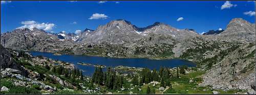
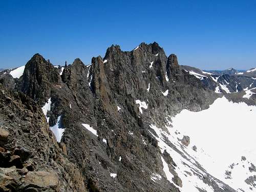
Knife Point Mountain is a very rugged 13er in the core group of peaks of the northern Wind River Range in Wyoming. At 13001 feet, it is the lowest 13er on the list (see the list here). It sits just south of the popular Indian Pass and a gendarme laden rugged ridge guards its summit from access from this pass. Hundreds of backpackers will see this profile off to the east as they hike up to the pass, but few will ever climb it. It's important to note the USGS maps mislabel the summit of this peak. The true summit is about 0.22 miles WNW of where the map shows.
Getting There
Use the Elkhart Park Trailhead accessed from Pinedale on the west side of the range and hike the Pole Creek Trail to Island Lake, passing by Photographers Point and Seneca Lake along the way. Just after passing over a small divide at 10,660 feet Island Lake will come into view. Descend to it and continue to the junction with the Titcomb and Indian Basin trails. Take the Indian Basin Trail heading east/rightward and hike past the Indian Lakes. The trail will jog to the west and seem like it's going the wrong way but it curves back and ascends a wide ramp back east to a tarn at 11,410 feet. From here the trail continues a short ways up to Indian Pass, but for Knife Point you'll leave the trail here to continue southeast.
Route - South Slopes Class 3
Continue SE cross country over a small hill and aim for the small Harrower Glacier. Traversing the next small drainage will likely involve some snow, and ascending this small glacier certainly will...crampons will be necessary if here in the early morning or if it's late in the season and icy. The steepness of the Harrower Glacier never exceeds 30 degrees. Aim for the 12,320 foot saddle immediately SW of the summit, cross over to its south side but don't descend. Make an eastward traverse on loose class 2/3 talus below the cliffs above. Once the terrain opens up above, begin ascending loose class 2+ rock up the south slopes for 450 feet until you hit the gentle south ridge and walk NW to the summit pinnacle. Climbing the summit pinnacle is a short easy 10 foot class 3 involving just a few moves, but there is some exposure to the north and west. The top is just big enough to touch with your hand, and definitely not big enough to sit or stand on. There is a ram skull at the base of the pinnacle instead of a summit register as of July 2020. To whoever carried that up there...you sir, are winning at life!
Red Tape/Camping
No red tape. Great Camping can be had at the two Indian Basin Lakes, or near the junction of the Indian/Titcomb Basin Trails.
When to Climb
Best time for summer conditions will be July - Early September. Ski touring would be advisable before June. The initial hike towards Seneca Lakes dries out a little earlier, but tons of snow typically persists in Indian Basin past July 4th, but will normally dry our by mid July.
Map
The map above shows the route up Knife Point via the orange line from the Indian/Titcomb Trail junction. The line also shows the routes I did that traverses to the Brown Cliffs HP, Jackson Peak, and Fremont Peak.
External Links
My Trip Report of Knife Point Mountain, and all the other 13ers in the Wind Rivers