
-
 41705 Hits
-
 85.87% Score
-
 21 Votes
|
|
Mountain/Rock |
|---|---|
|
|
51.11452°N / 115.30735°W |
|
|
8546 ft / 2605 m |
|
|
Overview
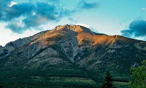
This peak is located just north-east of Canmore Alberta. It is a geat place to get some exercise and if the weather cooperates offers a fine view of the mountains on the opposite side of the Bow Valley. You can see most of the 18 peaks of Mount Rundle, Ha Ling peak, Miner peak, Lawrence Grassi, the Three Sisters, Rimwall, Mount Lougheed, and to the south, Grotto and Parts of Gap Peak to name just a few. It can take anywhere from 4 hour (if you are fit) upwards to 7 hours (if you are slower) to do this roundtrip from the trail head and back.
The peak is named after Lady Susan Agnes Macdonald, wife of Canada's first Prime Minister Sir John A. Macdonald.
Elevation gain 1,300 metres
Getting There
From Canmore centre drive on 1A south to Elk Run Boulevard and turn left. If you see a sign for the Alpine Club of Canada you have missed it. Turn back and turn right at the first street. Continue on this till you cross Cougar creek and park in a nice paved parking lot on your right. The trail starts on a paved bike trail that changes to gravel after about 300 yards. Continue along this trail which follows the creek for about 7 to 8 minutes. Once you go around a slight bend in the creek you will see the trail branches off up to the left up through the woods. You can not miss it, there are two large cairns.
Red Tape

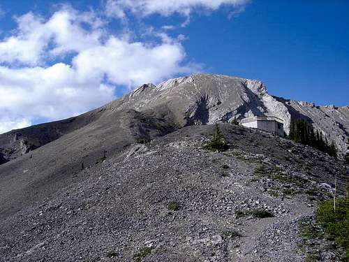
Summit ridge. You must pass this to gain the true summit.
There is no red tape but you should stay on the trail to avoid erosion. There is a local group that tries to maintain the route so please respect their efforts.
When To Climb
Summit ridge. You must pass this to gain the true summit.
Most of the people who do this scramble/hike do it beginning late April when the snow is gone from the summit area. Certainly all summer would be the preferred time. The top sections can be very tricky and slippery and due to the exposure levels at the very top can be dangerous under bad conditions.
Camping

View of Rundle from near the summit
This is a 1/2 or full day trip if you are slower.
There are campgrounds in the area if desired
Spray Lakes West Shore Campground has 50 sites (403) 591-7226
There is also the Alpine Club of Canada lodge with rooms and excellent facilities of 18$ CDN a night for members. The Alpine Club of Canada (403) 678-3200, ext 1
Mountain Conditions
Near the summit
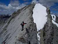
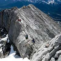
This is mostly a hike for the first 2 hours of the route. (Depending on your speed and fitness level). While I would label 95 percent of this scramble easy, I will repeat once again the top sections can be very tricky and slippery and due to the exposure levels at the very top can be dangerous under bad conditions. A lot of people skip the last 50 metres as too exposed. Don't feel bad if you do.
Contacts, weather and the ACC
Spray Lake Ranger Station. (403) 678-5533
Alberta Tourist Visitor Centre (403) 678-5277
Joining a club such as The Alpine Club of Canada is recommended when climbing in Canada. While it is not obligatory, useful information can be had at any of their Clubhouse in Canmore, or at their website which is open to everyone.
http://www.alpineclubofcanada.ca/
The Alpine Club of Canada (403) 678-3200, ext 1
weather office or (403) 762-2088 for weather conditions