
|
|
Mountain/Rock |
|---|---|
|
|
44.30730°N / 71.1663°W |
|
|
4584 ft / 1397 m |
|
|
Overview
Appalachian Mountains > White Mountains > Carter-Moriah Range > Mt Lethe and North Carter MtnMt Lethe 4584'
North Carter Mtn 4530'
Neither of these two peaks will ever grace the front page of Summitpost as the subject of a Photo of the Week. Even from its best angle, North Carter looks like a wooded ridge, and Mt Lethe, with under 100 feet of prominence on one side and a paltry 44 feet on the other, scarcely distinguishes itself from the nameless small knobs near the summit of Middle Carter. Neither peak has enough prominence to earn a spot on the AMC list of 4000-footers, and the name "Mt Lethe" isn't even recognized by the USGS.
Nevertheless, their heights are respectable (in the top twenty in New Hampshire), and they offer some good views despite falling short of treeline. Already visited by thousands of peak baggers and Appalachian Trail hikers making their way from Middle Carter to Mount Moriah, either or both of these peaks can also be reached in an easy loop hike from route 16.
Mt Lethe mysteries I have no idea why you'd name a mountain after a river that flows in Hades and causes forgetfulness, and neither, it seems, does anybody else. I had some trouble deciding which small bump was the actual Mt Lethe, and it seems I'm not the first: there is reason to think the bump labelled "Mt Lethe" on today's maps is not the same one that originally bore this name. further info on Views From the Top That's easy to believe, in a range where the positions of South Carter and Middle Carter in 1900 were not the same as they are today.
 |  |  |  |  |
Getting There
Mt Lethe and North Carter are located in the Carter-Moriah Range, just east of Route 16 to the south of Gorham, New Hampshire. If you're in a hurry, take Route 2 to Gorham, to avoid traffic in Jackson and North Conway (both in summer and during ski season). Route 2 can be reached from Interstate 93 via Route 3 (exit at the north end of Franconia Notch). If you'd prefer to savor the views, take the Kancamagus Highway (route 112) from Interstate 93 to Route 16.Trails
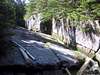
These peaks lie on or near the Carter-Moriah Trail (part of the Appalachian Trail) between Mount Moriah and Middle & South Carter; see those pages if interested in a longer hike passing over one of those peaks. On this page I'll describe the section between Imp Mountain on the north and Middle Carter to the south.This section of the Carter-Moriah trail is mostly an easy walk. On the northern slope of North Carter Mountain, however, it requires some scrambling, rising five hundred vertical feet in about a quarter of a mile.
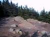
As Royswkr reminds me, the summit of Mt Lethe (pt 4584) is about a hundred yards east of the Carter-Moriah trail. He describes the bush here as "very thick" and notes that at the top there is a rocky outcrop with views of the Wild River valley.
The North Carter Trail reaches the Carter-Moriah Trail at the midpoint between Mt Lethe and North Carter; which are about a quarter mile apart. To reach the North Carter Trail from Route 16, take either branch of the Imp Trail. The North Carter trail itself is 1.2 miles long and ascends 1200 feet.
The Imp Trail is in fact a nearly-closed loop, with its southern and northern halves touching route 16 about 0.3 miles apart at the west end, and with the North Carter Trail at the east end. The northern branch passes alongside the cliffs of the Imp Face. The southern branch is slightly longer, significantly easier, and viewless. Either branch climbs about 2000 feet in about 3.1 miles.
A longer loop worth considering uses the Imp Trail (either branch), the North Carter Trail, and the Carter-Moriah Trail to Zeta Pass (just south of South Carter Mountain), returning to Route 16 via the Carter Dome Trail and Nineteen Mile Brook Trail. That leaves about two and a half miles of road travel between the 19 Mile Brook trailhead and the southern Imp trailhead. Confident navigators can find the old logging road which provides a shortcut between the southern Imp trail and Camp Dodge.
 |  |  |  |
Red Tape
Parking fees $3/day Advance (discount) purchase at most trailheads (but not at Imp Trail - ref Royswkr)Regulations limit camping, fires, etc. See backcountry camping section below. Rules there were distilled from several official sources including: this Forest Service page.
When To Climb
Year-round. Note that the northern slope of North Carter (Carter-Moriah Trail) is a sustained scramble and may be tricky when icy. Also, the many plank bridges, not all in perfect repair, could be a minor hazard when shrouded in snow. |  |
High Mountain Huts
No huts are very close; the nearest is Carter Notch Hut between Carter Dome and Wildcat. Open year-round on a self-service basis, reservations required. Availability Rates For more info: Pinkham Notch 603 466 2727Also of note is the Joe Dodge Lodge at Pinkham Notch Visitor Center on Route 16, which offers lodging and many other amenities year-round.
Trailside Campsites & Shelters
All campsites are first-come-first-served; reservations are not accepted but notification is requested for large groups. Campsites are often crowded, call ahead to estimate your odds of getting a spot. AMC Group Notification Line 603-466-2721, ext. 220; shelters@amcinfo.orgFor more info see the AMC's campsite profiles page
The nearest campsite to the summit is Imp Shelter & Campsite, located on top of Imp Mountain (to the north of North Carter). Fee ($8) and caretaker in season.
Three others that may be within striking distance are Rattle River Shelter to the north of Mt Moriah; and Spruce Brook Campsite and Perkins Notch Shelter, both located deep in the Wild River Valley to the southeast.
 |
Back-Country Camping
Allowed (subject to restrictions below), though it's not always easy to find a suitable campsite.Unless otherwise posted, you may camp:
- Below treeline (where trees are 8 feet or taller). exception: you may camp above treeline on top of at least two feet of snow.
- At least 200 feet from the trail and water sources.
- At least a quarter of a mile from any road or facility (ie, campsite, platform, shelter, hut).
- At least a quarter mile from Zeta Pass [near Mt Hight]
No camping or fires in designated Forest Protection areas. The list of sites can change from year to year, check with the rangers at Androscoggin: 603-466-2725
Roadside Campgrounds
One that is of particular interest for climbing Mt Lethe and North Carter is Wild River Campground, located at the end of Wild River Road near the bottom of the Moriah Brook Trail. Wild River Rd heads southwest from Rte 113 about 3 miles south of Rte 2. No reservations needed.Two more that are nearby are Dolly Copp and Barnes Field, both on Dolly Copp Road by Route 16 about half a mile north of the Imp Trail (ie, a few miles south of Gorham). Reservations 1-877-444-6777
WMNF campsite details [PDF]
Are they open yet?
Campgrounds are abundant in New Hampshire, consult your favorite yellow pages.
Mountain Conditions

The trails and summits are mostly wooded, thus offering some shelter from bad weather. Note that the northern slope of North Carter (Carter-Moriah Trail) is a sustained scramble and may be tricky when wet or icy.