
|
|
Mountain/Rock |
|---|---|
|
|
44.11600°N / 71.643°W |
|
|
4460 ft / 1359 m |
|
|
Overview
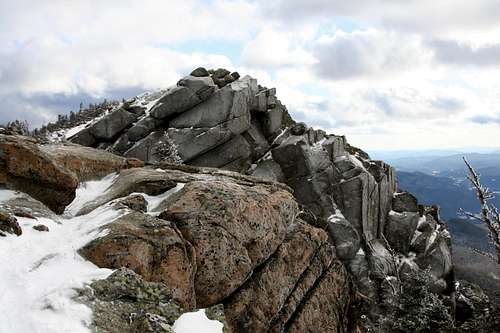 Mount Liberty in Winter
The towering sharp rock peak of Mt. Liberty (4460') serves as a striking landmark for anyone who is traveling through Franconia Ridge. Standing on the east side of the Notch, Mount Liberty is a well hiked summit in this region. The summit of Mt. Liberty is famous for its sharp pointy top which on the western end seems to drop off for hundreds of feet. Though often overshadowed by its towering northern neighbors of Mt. Lincoln and Mt. Lafayette, this peak gives a great 360 degree summit panorama that is only beat by its neighbors. Views of neighboring Lincoln and Lafayette as well many others can be seen from this rocky outcrop. A camera here is highly recommended.
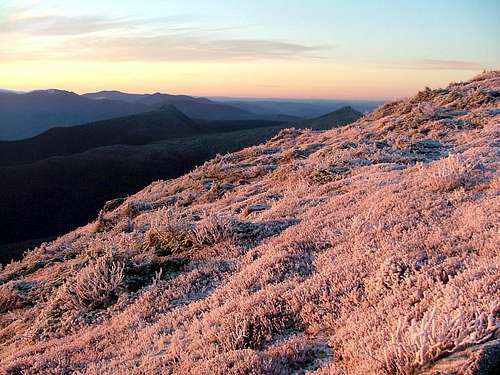 Viewed south from Franconia Ridge
Mt. Liberty is the easiest of Franconia Ridge peaks to summit if taken via the normal route. Its trail approach, The Whitehorse Trail-Liberty Spring Trail-Franconia Ridge (8.0 miles) is a steady and moderate but completely Class 1 hike. For the more adventurous and loop hikers this hike can be turned into a loop hike by add the Class 3 Flume Slide trail over neighboring Mt. Flume to the hike, turning it into a 9.9 mile loop hike. The Flume Slide trail should not be used for decent nor in icy conditions. For backpacker and extreme dayhikers there is the 33 mile Pemigwasset Traverse which includes Mt. Liberty in it's many summits.
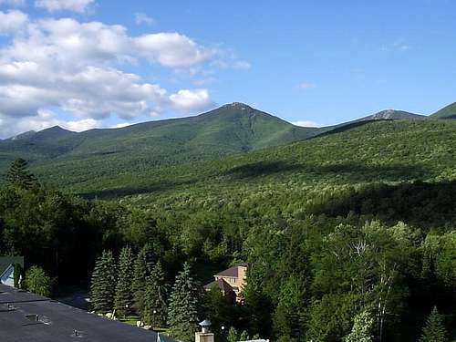 Mount Liberty in the summer as seen from the lower Franconia Notch Valley
Getting There
VIA LIBERTY SPRINGS TRAILHEAD:Liberty Springs Trailhead is accessible by the Whitehorse trailhead parking lot off Interstate 93 Northbound on the western side of the mountain. Give off Exit 33 and head past the Whale's Tale Waterpark, Indian Head Resort, the sign marking the entrace into Franconia Notch and the Flume Visitors Center. Signs will say "Trailhead Parking". With the exceptions of the summits of Mt. Flume & Mt. Liberty, follow the Appalachian Trail blazes. Take the Whitehouse Trail to Liberty Springs Trailhead (AT). Follow that trail until you reach Franconia Ridge Trail. Turn right (south) for Mt. Liberty summit & Mt. Flume (if desired). Turn left (north on AT) for Little Haystack, Mt. Lincoln, Mt. Lafayette & AMC Greenleaf Hut.
 |
Red Tape
This parking area is currently within the State Park. Therefore there are no fees unlike many of the other parking areas.
When To Climb
In summer and early fall this mountain is easily accessible via the steady Class 1 Liberty Spring Trail. Or if you want to make it a loop hike you can take the Class 3 Flume Slide Trail (ascent only for safety reasons) up to the top of Mt. Flume, traverse the ridge via the Franconia Ridge Trail and desend down the Liberty Spring trailhead.
In winter the Flume Slide Trail should not be attempted due to its Class 3 conditions, avalanche dangers and and the large amount of ice present on the slide. The Liberty Springs trail can be ascented with snowshoes and crampons. Still in winter keep close eye on the conditions because they can change dramatically in minutes.
April and early May are the times not to attempt Mt. Liberty due to the mud season.
Camping
No camping is allowed above treeline. However, Liberty Springs tentsite is located 3.2 miles from the parking lot and it is only about 0.7 miles from the summit (0.3 miles from Franconia Ridge Trail - an awesome traverse, second only to the Presidential Traverse!)
Mountain Conditions
Here are two websites that will provided you the best information on conditions in the White Mountains.
Appalachian Mountain Club
Number of routes up Mount Liberty
NOAA weather forecast
Summit Picture Log
Post your summit mugshot here.
 |
Check this out
Check out this thread about the acts of patriotism on Mt. Liberty.
External Links
- trail map [PDF format]
from the state park service - more accurate than Topozone