
|
|
Mountain/Rock |
|---|---|
|
|
44.20270°N / 71.5574°W |
|
|
4761 ft / 1451 m |
|
|
Overview
Appalachian Mountains > White Mountains > Twin Range > North Twin MountainNorth Twin is lower and less remote than its sibling South Twin, but it is still a very respectable peak by New England standards. In fact it ranks twelfth on the White Mountain 4000-Footer List and thirteenth on the New England Hundred Highest List. For that reason alone it is a popular peak for day hikers, and it is also frequently visited as a side trip from the Appalachian Trail, which crosses South Twin just about a mile away.
The northern approach to North Twin offers what may be the most challenging stream crossings on any official White Mountain trail. These can be partially avoided by some "bushwhacking" (the route is pretty well traveled), itself a novel experience for many White Mountain hikers.
The summit is treed in, but there is an outlook just a few steps away offering good views to the west, and there are also views from the ledges on the North Twin Trail and from exposed areas on the North Twin Spur. Assuming you have clear views in the desired direction, this guide will help you identify what you see.
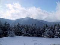 North Twin in winter
North Twin Mountain anchors the northern end of the main ridge of the Twin Range, which continues south over South Twin, Guyot, and the three peaks of Bond. A cross ridge is defined by Galehead Mountain and Zealand Mountain, and from the east end of that, the Little River Mountains (of which the highest is Mt Hale) extend to the north.
The nearby town is named Twin Mountain (singular), but the USGS lists North Twin as a mountain in its own right in their Geographic Names Information System, and you will find it labelled as such on any map.
 PAtN
PAtNNamed sub-peaks, not reachable by trail, are Haystack Mountain a.ka. the Nubble (2713'), and Peak Above the Nubble (3813'). The name "Peak Above the Nubble" is unofficial, but the peak is listed among the New England Hundred Highest, so it is probably the best-known sub-peak of North Twin. There is also some confusion as to whether Haystack and the Nubble are really the same peak or not - a common candidate for the name Nubble is the "east peak" (3460', just northeast of PATN). I choose to follow the conclusions of Papa Bear as discussed in comment #12.
Getting There
North Twin Mountain is located just north of the Pemigewasset Wilderness in the White Mountain National Forest. The usual approach is from the North. From Interstate 93, head east on Route 3 (just north of Franconia Notch State Park). For precise directions to the trailhead, see the Route page for the North Twin Trail.NOTE: Haystack Rd will be closed from first snowfall until it dries out in mid or late June.
Current status.
An approach from the south, over South Twin, is also possible. See the directions for South Twin, Galehead, or Guyot.
Trails Summary
The North Twin Trail reaches the summit from the east-northeast, after following the Little River from the north, starting from the end of Haystack Road (aka Forest Rd 304). See the Route page for details.The North Twin Spur connects the summit of North Twin to the summit of South Twin and the Appalachian Trail. South Twin is usually reached from the nearby Galehead Hut; see the South Twin page for details and for other possible approaches.
Starting from the North Twin Trail, a couple of large loops are possible by proceeding to South Twin and taking the Twinway east or west to some other northbound trail. However, with the exception of the abandoned Mt Hale Trail (better known as the "Fire Warden's Trail"), there is no way to close the loop without several miles of additional road travel.
Red Tape
White Mountain National Forest parking $3/day, or discount pass.Usual WMNF restrictions on camping, hunting, fishing, littering, etc.
When To Climb
Year-round. Note that Haystack Road is closed in winter and spring (current status); see the Route page for an alternative approach to the trailhead.Huts, Camping, Etc
High Mountain Huts Galehead hut
The nearest is Galehead Hut, located on the col joining South Twin to Galehead Mountain. Note that there is over a thousand-foot elevation difference between the hut and the summit of South Twin. Open mid-May to mid-October, reservations required.
Trailside Campsites
None in close proximity, though Guyot Campsite, located between Mts Guyot and Bond, is reachable, as is Garfield Ridge Campsite near the top of Mt Garfield.
Roadside Campgrounds
There are several campsites along Haystack Rd, apparently run by the WMNF. I can't find these listed anywhere online; try the Pemigewasset Ranger District at (603) 536-1315.
Three campgrounds in the region that let you reserve online are Sugarloaf One, Sugarloaf Two, and Zealand Campground. Here's a directory with some more.
Backcountry Camping is also permitted. Here are the rules:
Unless otherwise posted, you may only camp:
- Below treeline (where trees are 8 feet or taller).
(exception: in winter you may camp above treeline if there is at least three feet of snow under your tent (but you may not camp over bodies of water).
- At least 200 feet from the trail and water sources.
- At least a quarter of a mile from any road or facility (ie, campsite, platform, shelter, hut).
Mountain Conditions
New Hampshire trail conditions on Views From The Top
jniehof - Jul 5, 2007 5:35 pm - Hasn't voted
Summit locationAlthough the cairn is at the junction of the North Twin Trail and the North Twin spur, the true high point is a few dozen yards west along a short path leading to an outlook.