
|
|
Mountain/Rock |
|---|---|
|
|
37.56150°N / 122.4765°W |
|
|
1898 ft / 579 m |
|
|
Overview
 |
| 360° Panorama from Montara Mountain North Peak, February 16, 2002 |
Big news! Montara Mountain will soon be part of the Golden Gate National Recreation Area according to this article (Thanks to Dave K).
Montara Mountain, really just a massive ridge paralleling the San Andreas Fault, is one of the San Francisco Bay Area's more popular destinations for uphill-oriented hikers. Although the summit views from many other Bay Area high points are more expansive than Montara's, the western routes up the mountain climb through myriad coastal "microclimates" and provide stellar views of the Pacific Ocean. If not for the crowds who flock to Montara's slopes, it would be easy to forget, as one ascends from west, that the summit is only a stone's throw from one of the US's most populous metropolitan areas.
Radio antennas blanket Montara's Mountain summit, and although they undeniably detract from the aesthetic qualities of the place, the access roads provide ample choices for hikers, trail runners, equestrians, bikers, and yes, the odd service truck. Without this network of trails and roads, the thick brush which covers Montara and every other mountain in the area would render cross country travel all but impossible, as it does in the Ventana Wilderness to the south.
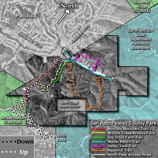
The "shortest route" distinction is shared (roughly) by the San Pedro Valley County Park (SPVCP) and Montara State Beach (MSB)/Mc Nee Ranch approaches. Both approaches are from the west and climb steeply from near sea level to 1900 feet over roughly four miles. The SPVCP approach ascends the steep valley between San Pedro and Montara Mountains, offering views of spectacular lush vegetation and even a 180-foot waterfall, quite a treat in the Bay Area. The MSB approach ascends over open territory, with spectacular views of the Pacific coast for almost the entire route.
From the east, Montara is a remote, challenging dayhike objective. The shortest (8 miles+) route, which follows Sweeney Ridge, begins at either Skyline College in San Bruno, or at the end of Sneath Lane. If a car shuttle can be arranged, or public transportation exploited, the linking together of a western and eastern approach could prove a satisfying and challenging trail running adventure of more than 10 miles distance with 2000+ feet of climbing, along good-quality paths. Unfortunately, this route is currently illegal, as the San Francisco Water Department and various other public agencies currently restrict access to the area. However... this is all about to change, as the SFPUC has approved limited public access to the restricted area. Hopefully as time goes on, access will be increased.
 |
Getting There
For detailed transit and climbing directions, please refer to individual route pages:
 |
Red Tape
Montara Mountain and environs are a hodgepodge of local, state, and national jurisdictions. If you choose to access from San Pedro Valley County Park, you are subject to a $4 entry fee for cars. Locals just park outside the park on the streets.
Camping...Montara Mountain is not far from the Bay Area Ridge Trail, though much of the surroundings are under the jurisdiction of non-camping-friendly government agencies (i.e., water districts). More research is needed here, although 99.5% of Montara hikers are not doing overnight trips.
When To Climb
Montara is climbed year around, by thousands of folks. The most crowded times are probably spring, when the wildflowers are in full bloom, followed closely by fall and summer. Winter still sees its fair share of climbers, though "cold" (almost never below freezing during daytime) weather limits their numbers.
The trails ascending from San Pedro Valley CP can get muddy from November to May. Other approaches are over hard, graded dirt roads, and thus suffer less from winter rains. Summer conditions range from oppressively hot (35 ° C, no clouds) to oppressively foggy (15 ° C, zero visibility, high wind) to pleasant (25 ° C, cool ocean breezes).
 |
Mountain Conditions
Pacifica, CA weather conditions, valid for the base of the western-side climbs. Expect temperatures 5 degrees F lower on the summit, with increased wind. As this area is prone to fast-moving fog and low clouds, Montara's summit may become enveloped in clouds at any time, further complicating the weather.
 |
Geology
Geologically, the Montara Mountain story is an interesting one, and adds much to the mystique of the place. Montara Mountain owes its steep slopes and relatively high elevation to the light, weathered granite which makes up the mountain's bulk and can be seen in numerous rock outcrops. The granite was emplaced in Cretaceous times (roughly 100 Mya), at the southern end of the Sierra Nevada...roughly 300 miles from its current position! The explanation for this puzzling offset is a textbook example of the dynamics of plate tectonics: around 15 Mya, in Miocene times, a transverse (strike/slip) fault system, now known in blanket terms as the San Andreas Fault, was activated. The original block of granite (called the "Salinian Block") was bisected by this new fault, with the western half (now Montara Mountain) riding with the Pacific Plate 300 miles to the north. The other half of the Salinian Block remains near Bakersfield, California.
External Links
- Montara and all its Glory
Undergraduate-level geological review of the Moss Beach area, including a nice description of Montara geology.
- SamTrans Access to Local Outdoor Areas
The San Mateo County Transit Authority (SamTrans) provides convenient bus service to San Pedro Valley County Park, as well as to Sweeney Ridge. Both provide hiking access to Montara Mountain.
- Morgan & Kim's old Montara trip reports
- Native Plants of Montara Mountain
Not so sure why they are snobby about "native plants", but this site illustrates the complexity of the "micro-climates" scattered around this huge mountain.
- Bay Area Hiker: Sweeney Ridge
Interesting page with detailed directions to Sweeney Ridge trailheads (Sneath Road entrance).
jpmossy - Feb 23, 2009 8:16 pm - Hasn't voted
camping on montara mountainalthough it's not entirely legal, camping on montara mountain is entirely safe. The best spot is in the small bowl inbetween north peak and peak mountain. I camped there over 30 times in one summer alone with no problems.
mpbro - Feb 23, 2009 9:59 pm - Hasn't voted
Re: camping on montara mountainHeh-heh, why not! Would be a beautiful evening given the right weather...
jpmossy - May 6, 2009 10:02 pm - Hasn't voted
Re: camping on montara mountainit's gorgeous on sunny days, the weather changes extremely fast in the summer, sometimes it's foggy and cold below 1000ft and above it its 80 degrees, sunny and windless! it's and interesting place, and right in my backyard!