
|
|
Mountain/Rock |
|---|---|
|
|
37.74620°N / 110.6194°W |
|
|
Garfield |
|
|
Hiking |
|
|
8245 ft / 2513 m |
|
|

Overview
The most southernmost mountain in the Henry Range, Mt. Ellsworth is a well known landmark to those who boat in Lake Powell. Together with its neighbor slightly to the north, Mt. Holmes, Ellsworth is part of the "little rockies", so named for their rugged appearance.Mt. Ellsworth is not quite as rugged in appearance as Mt. Holmes but the two together pose a striking picture when viewed. However, Mt. Ellsworth might be a bit easier to climb thanks to an old 4X4 road that takes you close to the base of what might be the best route up the mountain, the northwest ridge.
Mt. Ellsworth is one of the top 100 prominence peaks in the state of Utah, coming in at #42 with 2935 feet of prominence.
This is a desert peak, arid and rugged and not to be underestimated. While there might be many ways to climb up this peak, I can only volunteer information on the route we utilized and despite the information that is offered in the route section below, I recommend you do your homework on mapping and utilize a GPS/compass to help you find your way up AND down the mountain since no trail will lead you to the top and routefinding skills will be needed. This one is where you can test your cross country skills once you leave the 4X4 road that leads up to the base of this mountain.
A small antenna shack and antenna mar the summit but the shack did provide nice shade for the eating of our lunches. Two witness benchmarks were found as was a register found in the summit cairn. The actual highest point is just about twenty feet west of the shack and is obvious. The antenna set up is serviced by helicopter as noted by one of the signees in the register.
The origin of the name "Ellsworth" seems to be clouded in mystery although many feel that it was John Wesley Powell who did the naming but even that is in doubt. (See this info link for more on that if you are interested).
Getting There
From Salt Lake City, leave I-15 at Spanish Fork and take US 6 to I-70 near Green Water. Go west on I-70 about ten miles and watch for the exit to highway 24 (for Lake Powell & Hanksville) From Hanksville (last chance for gas & supplies), take Highway 95 south almost 27 miles and take a right at the junction with Highway 276. Follow Hwy 276 to the milepost 20 area where a 4WD road takes a left (just after a road cut). Traveling south, you will probably miss this hard to see road (no signing) but if you are heading north, you will see the 4X4 road clearly as it heads up a hill parallel to the highway. We missed it as we drove southbound but easily spotted it heading back north. There isn't the normal "driveway" appearance of a road leaving the highway but it is there.If you have a high clearance 4X4, you can assess your vehicle's ability to make it up that road. The crux is just after the first steep grade when it turns to the right. It gets steeper and looser and I put my Tacoma into the lowest low (H4) to get the traction necessary. If you can make it up this section, you can drive much closer to the mountain, saving you a mile to a mile and a half, depending on where you decide to park. If you don't have the above, park your vehicle down at the bottom, allowing room for the possibility of someone else using that road. Probably room for one car. Another spot exists for parking between MP 19 and MP 20.

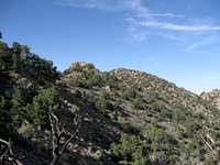
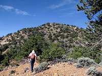
Route - North ridge
I've written a lot of route descriptions here at SP in the past but this one is difficult to describe. Yes, it was the north ridge and a huge help was Eric Willhite's description found on his website (see below) but when you are on the mountain, you need to pay attention to your routefinding efforts and to the pieces of the puzzle that unfolds as you go up the ridge. On our way up, we noted several cairns along the way and places where a trail seemed to be but the cairns were inconsistant so the need to know where you are at all times. If you have a good GPS that will keep a breadcrumb track that you can depend on, then you will be able to reverse your efforts as you descend later on. Working your way up the north side, stay near the ridge wherever possible. Near the top of the ridgeline, after you see the summit come into view, sidehilling across a couple talus slopes worked for us. I have some waypoints to transfer to a map which I hope to post in the near future.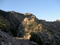 |  |  |
From the highway, plan on about a round trip effort of about 8 miles if you walk up the 4X4 road to the base of the north ridge (the route we used). Elevation gain from the road will be in the neighborhood of 3000 feet (probably a bit more when you factor in ups and downs both ways). From the end of the 4X4 road, it is close to 2 miles and a bit under 2000 feet of elevation gain.
 |  |  |
For another map of the route, I'd recommend that you visit Eric's page for that map, pics and his details. See next section below.
Summit stuff
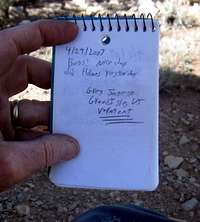
We found a register which was almost new and had only three people in it. However, both Lists of John and peakbagger.com show many more than that.Lists of John shows 20 visitors and peakbagger has 11. Go to peakbagger and you will find a link to the list of john register as well.
Red Tape
No red tape since this is BLM land although you are not to drive off roadFor more information, please contact:
Richfield Field Office
150 East 900 North
Richfield, Ut 84701
(435) 896-1500
Fax (435) 896-1550
utrfmail@blm.gov
There is also a BLM office in Hanksville which has maps and information about the Henry Mountains and the campgrounds.
Camping
Nearby Starr Springs Campground is a great choice for those who would like a table, vault toilet, and water (spring water). Run and maintained by the BLM, it is $4 a night and this is a nice campground. We found the toilets clean and site 2 had a couple spots for tents that were level. Site 3 also had a level tent site. Elevation: 6300 feet. 12 campsites at the southern tip of the Henry Mountains. Water was available when we visited but best to bring plenty just in case you find no water at the time of your visit. Scott's pic from a campsite area
You can also bush camp at several other spots along the road that leads up to Starr Creek and I noticed a spot almost at the very end of the 4X4 road where someone had camped. Very limited and not my choice of choices. As always, pack out any garbage you bring in and camp at spots where others have camped before you.
Weather (nearest town - Hanksville)
