
|
|
Mountain/Rock |
|---|---|
|
|
49.11100°N / 20.03700°E |
|
|
7851 ft / 2393 m |
|
|
Overview
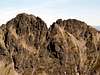
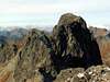
Mięguszowiecki Szczyt Pośredni / Prostredný Mengusovský Štít is a middle and the lowest summit of Mięguszowieckie Szczyt Group. It is interesting first of all for climbers, because the easiest way leading on the top is not so easy (UIAA I/II). But a view from the top is much limited by neighbouring Mięguszowiecki Szczyt Wielki and Mięguszowiecki Szczyt Czarny. For this reason it is visited much seldom than its neighbours and first of all by the way of making route of Mięguszowieckie Szczyty Group’ ridge. From the Polish side a few interesting climbing routes lead on the top through the north-east wall, too.

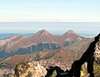
Mięguszowiecki Szczyt Wielki, Pośredni and Cubryna from Mięguszowiecki Szczyt Czarny
Mięguszowiecki Szczyt Pośredni is situated in the main ridge of Tatra Mountains, on Polish-Slovakian border. It is separated from Mięguszowiecki Szczyt Wielki / Vel’ký Mengusovský Štít by Mięguszowiecka Przełęcz Wyżnia / Vyšné Mengusovské Sedlo on the north-west and from Mięguszowiecki Szczyt Czarny / Východný Mengusovský Štít by Mięguszowiecka Przełęcz pod Chłopkiem / Mengusovské Sedlo on the south-east. And it ascend over Rybiego Potoku / Rybiho Potoka Valley on the north-east and Mengusovská / Mięguszowiecka Valley on the south-west. Mięguszowiecki Szczyt Pośredni are formed exactly by a few crags, from which three of them are recognized as its three summits – the most south-east is the highest and the most difficult to reach.
The name means more or less “the middle summit ascends over Mengusovská Valley” and I think it is not necessary to explain why. And name of Mengusovská Valley comes from a village Mengusovce on the south side of Tatra Mountains which was an owner of this area.
 |  |  |  |
First ascent
In summer: Włodzimierz Boldireff and Stanisław Porębski in 1903.
In winter: W. Délmar and Gyula Komarnicki in 1916.
 |  |  |
Getting There
FROM THE NORTH SIDE
From Polish side:
The best point to stars the journey is Zakopane – the biggest town on Polish side of Tatra Mountains. You can get there from Kraków by bus (most recommended), car or train:
By bus: there are a lot of buses from Kraków to Zakopane - time table of PKS and private lines Frey and Szwagropol.
By train: the road is much longer and dearer than by bus - time table from Kraków 0.00-11.59 a.m., 12.00-11.59 p.m. and from Zakopane.
By car: from Kraków take a road number 7 to Chyżne and follow it to Rabka. Here this road turn right to Chyżne, but you follow still straight a head in south direction by road number 95. In Poronin 5 km before Zakopane turn left (east) to border crossing point in Łysa Polana. Pass this point and go another 2 km to Polana Palenica, where you can leave your car on a big car-park. In a high season there is a problem with a place on this park (you must wait for a place sometimes a few hours) –in this case you can cross the border and leave your car on Slovakian side – the car-park is 100m after border crossing point on the right (and is much cheaper than on Polish side).
From Zakopane: Take a bus to Polana Palenica (time table of PKS, in high season there are a lot of private buses, too – a station is opposite to PKS) and go to the end to Polana Palenica (Attention! private buses sometimes has a direction-board “Morskie Oko”).
From Slovakian side:
The major city in this area is Poprad, where you can get by bus or train. From Poprad there is a lot of buses and trains to Starý Smokovec (13km) at the foot of Tatra:
train time table
bus time table
train time table from Poprad to Starý Smokovec Tatranská elektrická železnica
Maps of Starý Smokovec and Tatranská Lomnica
From Starý Smokovec take a bus to Tatranská Javorina - Lysá Pol’ana (time table) and cross the Slovakian-Polish border. From Łysa Polana you can take a bus or walk about 2 km to Polana Palenica.
In mountain:
From Polana Palenica take a asphalt road leading to Morskie Oko Chalet - it’s 8.5 km (about 1 h 30 min). If you wish you can get a horse and cart.
FROM THE SOUTH SIDE
From Slovakian side
How to get to Starý Smokovec see above.
From Starý Smokovec take a Tatranská elektrická železnica (better) or bus to Popradské Pleso (it is only a little station among a forest) or Štrbské Pleso.
From Polish side:
How to get to Zakopane see above.
From Zakopane take a bus to Polana Palenica (time table of PKS, in high season there are a lot of private buses, too – a station is opposite to PKS) and get off in Lysá Pol’ana / Łysa Polana. Cross the polish-slovakian border . Bus station on Slovakian side is about 100m after border crossing point on the right. Take a bus to Poprad, which goes through Starý Smokovec (time table).
From Starý Smokovec take a Tatranská elektrická železnica (better) or bus to Popradské Pleso (it is only a little station among a forest) or Štrbské Pleso.
In mountain:
From Popradské Pleso: take a a blue-marked trail leading to Chata Popradské Pleso (about 1 h).
From Štrbské Pleso: follow a road (blue-marked trail) leading to the lake (Štrbské Pleso) as you reach a shore and turn right and take a red-marked trail leading to Chata Popradské Pleso (about 1 h 30 min).
 |  |
Maps

Map of Pośredni Szczyt Mięguszowiecki’ area
Tatry Wysokie, in scale 1:25 000, description in 6 languages, ISBN 83-87873-26-8, available in all shops in Zakopane. Here you can look at net version.
A high quality maps in scales 1:25 000 and 1:50 000 are produced VKU Harmanec, too. They are available at all chalets and shops in cities under Vysoke Tatry.
When To Climb
The best time is a summer and early autumn (july-september). But all the year Mięguszowiecki Szczyt Pośredni is available.
Red Tape
The “High Tatra” is a National park, UN Bioheritage area and a European BioHeritage - if you are not a member of any climbing club you can move only on marked trails - so you can visit Pośredni Szczyt Mięguszowiecki only with tatra guide.
In winter time (from November the 1st – June the 15th) The Tatra Mountains in slovakian part are closed for normal tourists (not for climbers). In Polish part you can move the whole of year.
For more informations look at High Tatra/Vysoke Tatry GROUP page.
For climbing regulations look at Gerlachovsky Stit page.
Accommodation
There are 3 chalets near by Mięguszowiecki Szczyt Pośredni:
Schronisko przy Morskim Oku – situated in Poland in the Rybiego Potoku Valley by the Morskie Oko (Sea’ Eye). Chalet is opened all the year for hiking, climbing and ski mountaineering. Exactly there are to buildings: „new” – it’s a mountain hotel with restaurant and „old” - maybe less comfortable, but with unforgettable climate (but there is a hot water in coeducational bath, kitchen and boots-dryer J).
Access from:
1. Polana Palenica przed Morskim Okiem - red marked trail, 3 hours
2. Schronisko w Dolinie Piêciu Stawów Polskich (Hut in Five Polish Lakes Valley)
- blue marked trail (by Œwistówka), 1 h 40 min
- blue/yellow marked trail (by Szpiglasowa pass), 2 h 45 min
3. Chata pod Rysmi - red marked trails, 4 h (attention! by the way you cross the Polish-Slovakian border!)
Contact:
Poland, 34-500 Zakopane, skr. poczt. 201
telephone: +48 18 20 776 09
Schronisko w Dolinie Roztoki is situated in Poland by mouth Roztoki Valley to Bialej Wody (Bielovodska) Valley. Chalet is opened all the year for hiking, climbing and ski mountaineering, but in winter time it’s better to phone earlier. If you don’t like crowded Schronisko przy Morskim Oku, here you find calmness and silence (but not in very high season).
Access from:
1. Polana Palenica przed Morskim Okiem – red/green marked trail, 1 hours (in high season there is a lot of buses from Zakopane to Palenica, but in low season you can only depend on PKS - time table: http://www.zakopane.biz/poradnik/pks.php)
2. Schronisko w Dolinie Pieciu Stawów Polskich (Hut in Five Polish Lakes Valley)
- green marked trail, 2 h
3. Schronisko przy Morskim Oku - red marked trails, 1 h 30min
Contact:
Poland, 34-500 Zakopane, skr. poczt. 200
telephone: +48 18 20 77 442
The mountain hotel Chata pri Popradskom plese - situated in Slovakia in the picturesque surroundings of Mengusovská Valley on the bank of mountain lake Popradské Pleso. To the south from chalet, by the yellow-marked trail is located a memorial of victims of the High Tatras and other mountains Symbolicky cintorin which is worthy of visit.
Access from:
1. Štrbské Pleso via the red-marked trail “Tatranská Magistrála” (1 h 30 min)
2. Popradské Pleso (TŽE station) via blue-marked trail (1 h)
3. Sliezky Dom via the red-marked trail “Tatranská Magistrála” (3 h 30 min)
4. Chata pod Rysmi via red/blue – marked trail (1 h 45 min)
Contact:
phone: ++421-52-4492177 or ++421-52-4492765
mail: popradskepleso@horskyhotel.sk
Absolutely no camping is permitted in the nature park. The nearest camping in Polish side is in Zakopane:
1. Camping pod Krokwią, 34-500 Zakopane Żeromskiego Str., phone/fax: + 48-18-201-22-56, email: camp@podkrokwia.pl
2. Camping KS SN PTT-1907, 34-500 Zakopane Za Strugiem 39 Str., phone/fax:+48-18-201-55-12
3. Camping Harenda, 34-500 Zakopane oś. Harenda 51b, phone/fax: +48-18-20-147-00
For members of any climbing club there is a one camping place - obozowisko taternickie PZA “Szałasiska” in Rybiego Potoku Valley (not far from Morskie Oko) – contact: Ania Szymkowska-Czyż, phone: +48-607 431790, e-mail ASC@interia.pl.
The nearest camping in Slovakian side is in Stara Lesna and Tatranska Lomnica.
There are plenty of cheap hotels and pensions in the area of Zakopane and Štrbské Pleso.
accommodation in Štrbské Pleso
accommodation in Zakopane
Mountain Conditions
Web forecast:
situation at this moment and forecast
Information of avalanche danger:
TOPR (in English) and HZS
Rescue:
On Slovakian side acts HZS (Horska Zachranna Sluzba)
Starý Smokovec 23, 059 60 Vysoké Tatry
phon.: 052/4422820, fax: 052/4422855,
mobil: 0903624869
e-mail: vtatry@hzs.sk
www.hzs.sk
On Polish side acts TOPR (Tatrzanskie Ochotnicze Pogotowie Ratunkowe)
adress: 34-500 Zakopane, ul.Pilsudskiego 63a,
phone: (+48)(18) 2014731 fax : (+48)(18) 2015560
E-mail: topr@topr.pl
www.topr.pl
rescue phone: (+48) 601-100-300