
|
|
Mountain/Rock |
|---|---|
|
|
42.13122°N / 74.15042°W |
|
|
Hiking |
|
|
Spring, Summer, Fall, Winter |
|
|
3800 ft / 1158 m |
|
|
Overview
Sugarloaf is located in the Indain Head Wilderness area and is an excellent mountain by many standards. The rugged Devils Path crosses it's summit and there is no "walk up" routes to the top. In fact, Sugarloaf and the surrounding mountains along the Devils Path, Indian Head, Twin, and Plateau contain the most difficult hiking in all of the Catskills. Both the east and west approaches to Sugarloaf on the Devils Path require some short sections of class 2+ hiking, the western approach being the more difficult of the two. Along the Devils Path on the western approach
The actual summit is viewless but there is a short spur trail that leads south to an excellent viewpoint where Slide Mountain can be seen as well as the rest of the central high peaks. From the eastern approach to Sugarloaf are good views of Twin Mountain and from the western approach, Plateau can be seen.
 The view of the Central High peaks from the summit viewpoint.
The views and challenging terrain make Sugarloaf an excellent Catskill hike. The summit area is thick with Balsam Fir and for most of the year is a glowing verdant paradise with bright moss blanketing the landscape.
One of the approaches, the Pecoy Notch Trail passes through an old stone quarry, where some locals have built some artistic stone configurations from the excess rock, including large stone chairs in which one can sit and look over the valley to Roundtop and Kaaterskill High Peak.
 The stone throne along the Pecoy Notch Trail.
The other approach, the Mink Hollow Trail, parts of which are an old woods path where oxen carried people and uncured hides through Mink Hollow (a deep notch between Sugarloaf and Plateau), follows a creek on the southern side, and travels through an enchanting pine forest on the northern side that delights the eye with every turn.
 Twin from the east side of Sugarloaf
Sugarloaf ranks thirteenth in order of height of the Catskill 3500'ers
Trailheads & acess to Sugarloaf
I highly suggest the maps by the New York/New Jersey Trail Conference. These maps are quite accurate making both trail travel and trailhead locating by road very easy.For further details on this area & trails, a copy of the Catskill Mountain Guide by Peter W. Kick, an Appalachian Mountain Club book, would be an excellent resource
-The Roaring Brook Parking Area/Trailhead:
From this Trailhead there are two options for reaching the summit of Sugarloaf. I will explain this as a loop hike ascending the tougher western side and descending the easier eastern path.
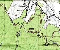 The area & trails surrounding Sugarloaf
From the parking lot, travel .25 Mi. on the yellow blazed Roaring Kill Trail.
Turn right at the first junction on the blue blazed Mink Hollow Trail. (class 1)This part of the trail travels through the enchanting forest I mentioned earlier. Take this trail for 2.65 Mi. to the junction with the Devils Path. Just a few steps further on the Mink Hollow trail is the Mink Hollow Lean-To.
Turn left onto the red blazed Devils Path and the summit is reached in.9 Mi. This section of trail is steep with some solid sections of class 2+ hiking.
From the summit (don't forget to take the short southerly spur trail to the viewpoint and back) continue east on the Devils Path, traveling through the thick emerald landscape and Balsam Firs and descending on some short class 2 sections for 1.2 Mi. reaching Pecoy Notch.
Turn left onto the Pecoy Notch Trail (class 1) for 1.7 Mi. passing a beaver dam that was built right over the trail! and the stone quarry area mentioned earlier.
At this point the Roaring Brook Trail is again reached. Retrace your steps for .25 Mi. to the parking area.
-Mink Hollow Road Trailhead: (1500 FT.)
Directions: From exit 19 on the New York State Thruway (I-87) travel 5.8 Mi. on Route 28 west
Turn right onto NY 375 and go 2.8 Mi.
Turn left onto NY 212 (Mill Hill Rd) and go .4 Mi
Turn right onto Cr 33 (Rock City RD.) and go .3 Mi.
Turn left onto Lower Byrdcliffe Rd to continue on Cr33 and travel .4 Mi.
Turn left onto Glasco Turnpike to continue on Cr 33 and go 2 Mi.
Turn right onto NY 212 and travel 1.7 Mi.
Turn right onto Mink Hollow Rd.
The parking area/trailhead is at the end of Mink Hollow Road
-Mink Hollow Trail: 6.8 Mi. 2300 Ft, Elev. gain (one way)
This is a great day hike also but is an out & back.
From the parking area, take the blue blazed Mink Hollow Trail.
Following a creek, there is one stream crossing right away and another more diffucult one later on. the trail is easy but beautiful and steepens some towards Mink Hollow. At 5.8 Mi., the Mink Hollow Lean-To is reached and at 5.9 Mi. is the junction with the Devils Path.
Turn right onto the Devils Path .9 Mi. to the summit. This is the western approach mentioned above.
Camping
The Mink Hollow Lean-To is the only organized camping in this area.The Roaring Brook Trailhead is surrounded by the Indian Head Wilderness and camping is allowed on both sides of the road. Observe the red tape section below for regulations regarding Catskill camping.
Red Tape & Backcountry Camping
If camping in the wilderness, these regulations are to be followed:For backcountry camping permits (when neccesary, see below) visit the DEC website under services.
-Pack it in-pack it out
-No more than three succesive nights or more than ten nights per year can be spent in trailside lean-tos.
-A permit must be obtained from the DEC forest rangers if camping more than three succesive nights or in groups of ten or more. No permits will be issued to anyone under the age of 18.
-The DEC may take down & remove any tent or camping structure that is left alone for more than 48 hours
-No camping above 3500' between March 22 and December 20.
-No fires shall be left unattended
-No camping within 150 feet of any road, trail, spring, stream, or other bodies of water except in camping areas designated by the DEC.
-Rangers do Frequent these mountains.
Some Images from this area:
 moss covered boulder along the Pecoy Notch Trail
 Beautiful growth on a dead tree along the Mink Hollow Trail
 moss covered cairn along the Pecoy Notch Trail
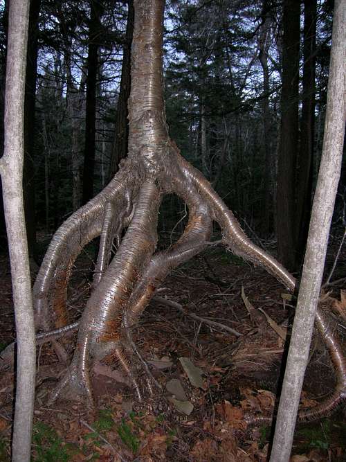 Interesting roots of a birch along the Mink Hollow Trail
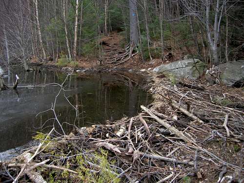 The Pecoy Notch Trail (center top) taken over by mr beaver