
|
|
Mountain/Rock |
|---|---|
|
|
45.03180°N / 70.3132°W |
|
|
4237 ft / 1291 m |
|
|
Overview
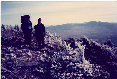
Known throughout the Northeast primarily as a destination ski resort, this 4,237-foot mountain also boasts the 3rd highest peak in the State of Maine, trailing only Baxter and Hamlin Peaks on Katahdin. It also offers hikers some of the best views outside of Baxter State Park.While there are many ways to ascend this mountain, the traditional hiker approach begins along the rugged seasonal-use Caribou Valley Road. Over the years, CVR (as the road is known) has gone through several cycles of deterioration and refurbishing according to the whims of the logging companies who maintain it. As such, there are no true parking areas or trailheads along CVR although hikers regularly utilize the road for accessing not only Sugarloaf but Reddington, South Crocker and Spaulding as well. The Appalachian Trail crosses CVR approximately 4.5 miles from Maine State Route 27. Set your odometer and keep an eye out for the white blazes as it is very easy to miss the crossing. Hop on the AT southbound, which leaves the east side of the road. To the west, the AT ascends the slopes of South Crocker.
Update from Technicolor NH (6/10/16): The Caribou Valley Road is now gated one half mile from the Appalachian Trail crossing. The metal grate bridge just beyond it has decayed enough that the owners of the road have decided to bar entry beyond it although be aware that at least one wooden bridge on the way in was looking pretty rough as well. Still passable as of this writing but as Nartreb said on the Spaulding page, check the bridges on foot BEFORE crossing them, particularly if it has been some time since I wrote this comment. There is a parking area off to the side just before the gate sufficient for four vehicles at least, with enough space to park on the road in many places. Someone installed a board bridge at the stream crossing, which makes the initial water crossing much easier. Someone also installed a mileage sign on the AT at the junction to the side trail to the summit of Sugarloaf that indicates that the mileage was 2.3 miles north to the CVR, 4.4 miles to South Crocker, 5.4 miles to North Crocker, and 10.6 miles to Maine Highway 27. From that intersection a separate sign says it is 2.1 miles south to Spaulding Mountain.
Once on the trail, you're in for a treat. The Appalachian Trail climbs moderately at first and then steeply with a brief rock scramble in the early going. Little more than a mile from CVR, the trail winds to breathtaking views to the south of the western cirque of Sugarloaf. The trail continues to the junction with the blue-blazed Sugarloaf Side trail on the left at 1.9 miles. To the right, the AT continues to Spaulding. Follow the Sugarloaf side trail for another 6/10 of a mile to the summit and the top of the ski area. The views are spectacular and the Carrabassett Region is truly one of the gems of the Northeast.
I first climbed this peak one March during a ferocious snow storm and if you're willing to add some miles to your hike, a ski trail descent makes for an enjoyable loop. Once at the bottom of the ski area, just work your way back to State Route 27 and turn left (west). CVR will be on your left just about a mile from the ski area.
Maine Mountain Guide and Maps are recommended.
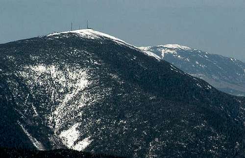
![Sugarloaf as viewed from the...]()
Sugarloaf from the south with the Bigelows beyond
![View East]()
Burnt Hill seen from the summit of Sugarloaf
There are also numerous camping areas maintained by the Maine Forest Service throughout the Rangeley/Stratton region.
Contributed by RobA:
Miles are calculated from the start of the A.T. side trail to the summit.
Crocker Cirque Campsite elev. 2,710 ft. 3.3 miles north on the A.T. Water source is the spring.
Spaulding Mountain Lean-To elev. 3,140 ft. 2.9 miles south. Sleeps eight. Water source is a spring.
Source: 2002 A.T. Thru-Hikers Companion
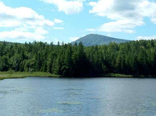
![Sugarloaf from Stratton Brook...]()
Sugarloaf from Stratton Brook
Ski Sugarloaf here
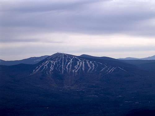
![Sugarloaf]()
Sugarloaf and the ski area as seen from Bigelow

Official Website of the Ski Area
Maine Appalachian Trail Club
MATC is a volunteer nonprofit corporation that manages 267 miles of the Appalachian Trail in Maine, its facilities and corridor. MATC is a trail maintenance club, not a hiking club. Anyone is welcome to come out on trail work projects with the club or its Maine Trail Crew.
Here's a view of Sugarloaf from the crest of the Bigelow Range, across the Carrabassett Valley. This was taken Columbus Day weekend, 1985. The rime ice was already forming on the summit ridge. Winter can come early to the Maine mountains. Be prepared!
Once on the trail, you're in for a treat. The Appalachian Trail climbs moderately at first and then steeply with a brief rock scramble in the early going. Little more than a mile from CVR, the trail winds to breathtaking views to the south of the western cirque of Sugarloaf. The trail continues to the junction with the blue-blazed Sugarloaf Side trail on the left at 1.9 miles. To the right, the AT continues to Spaulding. Follow the Sugarloaf side trail for another 6/10 of a mile to the summit and the top of the ski area. The views are spectacular and the Carrabassett Region is truly one of the gems of the Northeast.
I first climbed this peak one March during a ferocious snow storm and if you're willing to add some miles to your hike, a ski trail descent makes for an enjoyable loop. Once at the bottom of the ski area, just work your way back to State Route 27 and turn left (west). CVR will be on your left just about a mile from the ski area.
Maine Mountain Guide and Maps are recommended.
Sugarloaf from the south with the Bigelows beyond
Getting There
Caribou Valley Road is located along the south side of State Route 27 approximately one mile west of the Sugarloaf ski area. Sugarloaf USA is in the Carrabassett Valley Region between the villages of Kingfield and Stratton.Red Tape
Be prepared to walk Caribou Valley Road. Though the road has been well-maintained in recent years, you never know when a storm may wash it out. Not a bad idea to bring a mountain bike along or cross-country skis in winter (road is not maintained in winter but is used by snowmobilers).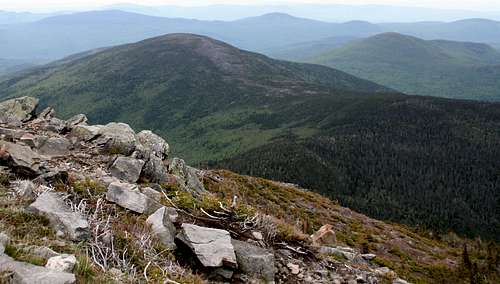
Burnt Hill seen from the summit of Sugarloaf
When To Climb
Year-round climbing although this area receives some of the heaviest snowfall in the Northeast.Camping
There is always camping available along the Appalachian Trail. The nearest designated tent sites are at the Crocker Cirque tentsite less than a mile west of Caribou Valley Road on the AT and at the Spaulding Mountain campsite about a mile south of Spaulding Mountain.There are also numerous camping areas maintained by the Maine Forest Service throughout the Rangeley/Stratton region.
Contributed by RobA:
Miles are calculated from the start of the A.T. side trail to the summit.
Crocker Cirque Campsite elev. 2,710 ft. 3.3 miles north on the A.T. Water source is the spring.
Spaulding Mountain Lean-To elev. 3,140 ft. 2.9 miles south. Sleeps eight. Water source is a spring.
Source: 2002 A.T. Thru-Hikers Companion
Sugarloaf from Stratton Brook
Ski Sugarloaf
What more can you say? Only Sunday River rivals this mountain as far as Maine skiing is concerned. 134 trails ranging from green to double black diamond; over 55 miles of skiing on 664 acres of terrain.Ski Sugarloaf here
Sugarloaf and the ski area as seen from Bigelow
Local Weather
External Links
Ski SugarloafOfficial Website of the Ski Area
Maine Appalachian Trail Club
MATC is a volunteer nonprofit corporation that manages 267 miles of the Appalachian Trail in Maine, its facilities and corridor. MATC is a trail maintenance club, not a hiking club. Anyone is welcome to come out on trail work projects with the club or its Maine Trail Crew.
Personal Stuff
Former page maintainer Bark Eater climbed Sugarloaf in the summer of 1987 with his best hiking buddy Rainier. They section hiked most of the Maine AT together. She was the best trail dog ever!Here's a view of Sugarloaf from the crest of the Bigelow Range, across the Carrabassett Valley. This was taken Columbus Day weekend, 1985. The rime ice was already forming on the summit ridge. Winter can come early to the Maine mountains. Be prepared!
Page author and current maintainer Puma concolor thanks Bark Eater for his several years of stewardship of this oage.
![Sugarloaf from the Bigelows]()
Sugarloaf From the Bigelows
Sugarloaf From the Bigelows
injektilo - Apr 10, 2006 3:38 pm - Voted 10/10
PermafrostAccording to the book "Roadside Geology of Maine", by D.W. Caldwell, an investigation of unstable supports on the ski gondola revealed permafrost (permanently frozen ground). Permafrost occurs in climates where the mean annual temperature is below freezing.
revkon - Mar 12, 2014 2:04 pm - Hasn't voted
Trail mileage discrepancy?I hiked Sugarloaf recently (3/8/14), and wanted to point out that the sign at the intersection of the A.T. and the Sugarloaf side trail indicates different mileages from what's listed above. I probably should have taken a picture, but what I recall from memory is this: .5 miles to Sugarloaf summit X.4 miles to CVR (where X has been scratched out. the numbers 2 and 3 have both been scratched in above X) 5.0 miles to Crocker 9.9 miles to route 27 I'm inclined to believe 2.4 miles is the more accurate measurement for the distance to CVR, but this is based entirely on my hiking time and subjective "feel" for the trail length. I have a hard time swallowing the 1.9 measurement, given 2 hours of hustling through the snow with minimal rest.
Bark Eater - Mar 15, 2014 1:35 pm - Hasn't voted
Re: Trail mileage discrepancy?Thanks too from me. The 1.9 mile distance to the junction is consistent with my Maine Appalachian Trail guide, which unfortunately is even more dated than Catamount's reference. Much of the trail in Maine has been re-routed since the 1980s when I explored the area. It certainly could have been re-routed to add an extra half mile.
dcherry - Oct 19, 2015 1:36 pm - Hasn't voted
Update on Geraldine LargaySad news, but it appears that they have found her remains. http://bangordailynews.com/2015/10/16/news/state/bittersweet-day-as-missing-at-hiker-geraldine-largays-remains-believed-to-be-found-in-western-maine/
Bark Eater - Oct 21, 2015 2:12 pm - Hasn't voted
Re: Update on Geraldine LargayThanks for letting us know.
technicolorNH - Jun 10, 2016 12:38 am - Hasn't voted
Access from the CVRThe Caribou Valley Road is now gated one half mile from the Appalachian Trail crossing. The metal grate bridge just beyond it has decayed enough that the owners of the road have decided to bar entry beyond it although be aware that at least one wooden bridge on the way in was looking pretty rough as well. Still passable as of this writing but as Nartreb said on the Spaulding page, check the bridges on foot BEFORE crossing them, particularly if it has been some time since I wrote this comment. There is a parking area off to the side just before the gate sufficient for seven vehicles at least, with enough space to park on the road in many places. Someone installed a board bridge at the stream crossing, which makes the initial water crossing much easier. Someone also installed a mileage sign on the AT at the junction to the side trail to the summit of Sugarloaf that indicates that the mileage was 2.3 miles north to the CVR, 4.4 miles to South Crocker, 5.4 miles to North Crocker, and 10.6 miles to Maine Highway 27. From that intersection a separate sign says it is 2.1 miles south to Spaulding Mountain.
Bark Eater - Jun 15, 2016 2:36 pm - Hasn't voted
Re: Access from the CVRThanks. I updated the page with your comments.