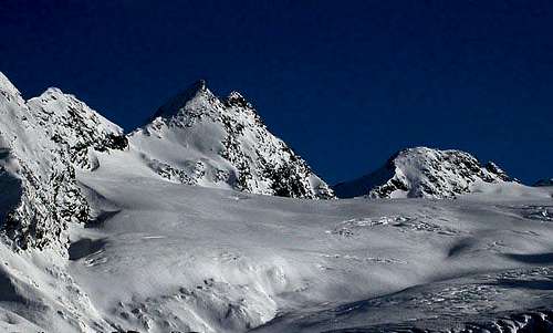
Château Blanc
(3.408m) rises directly to the north of Testa del Rutor, or, more precisely, of Colle del Rutor, on the ridge that separates Valle di La Thuile from Valgrisenche. The divide goes on to form the Summits of Doravidi (South,
3.439m), and (North,
3.439m), and of Flambeau
(3.315m). It finally descends to Colle di Planaval
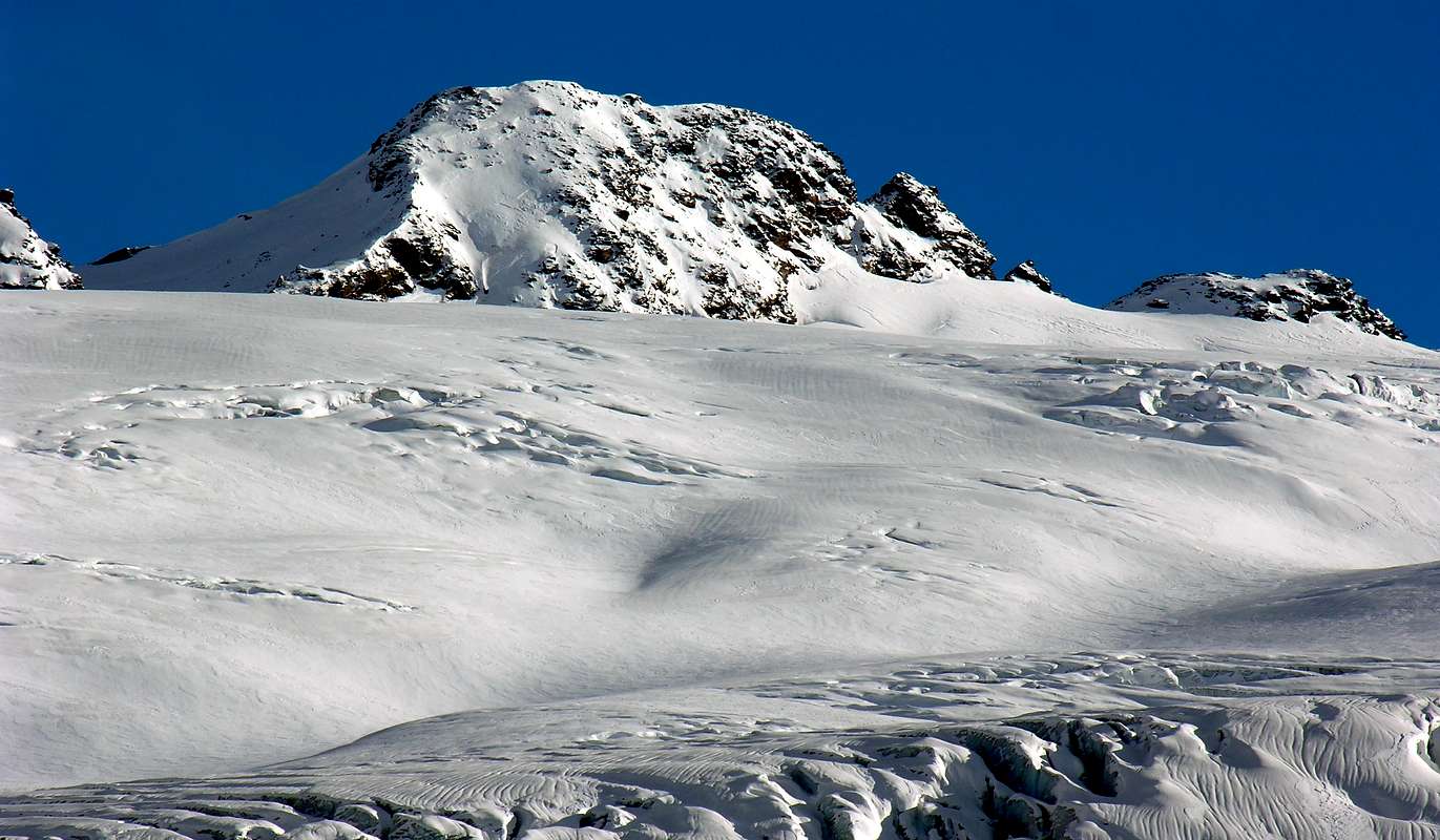
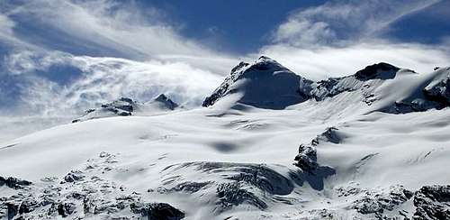
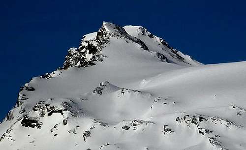
(3.016m). The gentle ridge is flanked by ample glaciers that climb up its sides to the summits. From the City of Aosta, it looks like the ridge gains elevation until Château Blanc, but has lost some once it gets to Testa del Rutor. This is only due to perspective, though, because Testa del Rutor is about eighty meter taller. Mont Château Blanc (White Castle, because it is entirely covered by ice) comprises two peaks, North
(3.408m) and South
(3.405m). From the summit one enjoys vast and spectacular views of all the mountains of Valle d'Aosta.
First Ascents
- First ascent (W Slope: F. Gonnella and Calvi di Bergolo, (1875).
- N Arête: Mario Valasco, Ignazio and Vittorio Belfront, (Aug 20th, 1890).
- Integral crossing (Planaval Pass-Testa del Rutor): O. Cardellina, C. Cardellina, M. Cossard and G. Lamazzi, (Aug 07th, 1993).
- N-NE Arête: J. J. Weilenmann, (Aug 10th, (1858).
Getting There
BY CAR:
- From Torino, Milano, etc: Motorway A5. Exit at Morgex.
- From Switzerland: through the Grand Saint Bernard Tunnel or the namesake Pass.
- From France: through the Mont Blanc Tunnel or Petit Saint Bernard Pass: It is not necessary to take Motorway A5: you can drive on SS.26, in the direction of Aosta.
BY PLANE:
- Aeroporto "Corrado Gex" Saint Christophe (Aosta).
From the Morgex
(921m), exit of Motorway A5, continue for about 3 km on Strada Statale (National Road) n°26 towards Pré Saint Didier
(1.017m). SS.26 becomes the main street of the small city and then continues toward Colle del Piccolo San Bernardo. After several hairpins, and past the Villages of Elevaz
(1.302m) and la Balme
(1.309m) reach the famous ski resort of La Thuile
(1.441m). Turn left on the bridge that crosses "Dora di La Thuile" in the direction of the Village of La Joux. After about 2 km from the bridge, having past a large square, cross another bridge on the "Dora" to the right. (From this point on, the road, altough paved, is quite narrow. Proceed with caution.) After 1 km get to La Joux
(1.607m) and park in one of the two parking lots, which are large but sometimes fill up in August. For this reason, access past the second bridge is limited at certain times. Be there before 9 AM to avoid problems, or take the shuttle bus to cover the last stretch.
Route (first day)
The ascent for Rifugio A. Deffeyes starts in front of "Bar Delle Cascate" on trail
n° 3. Pass a wooden bridge on the left and after about
15 minutes you'll come to the first of the three spectacular Rutor Falls. Continue along the trail and leave Alpeggio di Parchet
(1.772m) to your right. The trail continues up large steps and in a bit less than one hour passes by the second waterfall, which is not visible from the trail, but is marked by a sign. After another 15 minutes you'll reach the sign for the the third waterfall. Continue on the steep trail for another
20 minutes to a fork. Take the well-marked left branch that leads to the hut.(The right branch, numbered 8, leads to the beautiful Lakes of Bella Comba.) Climb to the small col
(2.130m) and then descend bending slightly to the right until Lago Glacier
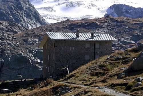
(2.143m). Cross the small wooden bridge over the lake outlet and, leaving Alpeggio Glacier to your right, climb the steep and wide switchbacks to the plateau where Rifugio Albert Deffeyes is located at
(2.494m). This is a good place to spend the night (
2h'45/3h'00 from La Joux) before starting the route.
Route (second day)
Descend for about
50m the trail for the inlet stream of Lago Azzurro. Cross the small wooden bridge and keep the right trail that leads to the upper Rutor Lakes
(2.539m). After about
10 minutes the trail forks. Keep left and reach shorlty after a small lake known by the names of "Dans la Roche" or "Lac Sans Nom"
(2.602m). Continue up to a small col at approximately
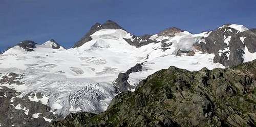
2.680m and on to the left moraine of the huge Rutor Glacier. (Here at
2.790m you'll find fixed ropes that have been recently placed after the moraine slid on the glacier. This is perhaps the most difficult spot of the entire ascent.) Past this point, leave on your left the small valley that leads to Colle di Planaval
(3.016m). Continue the ascent to reach the left branch of the glacier, located directly under Flambeau (
3.315m). Continue the ascent with the rocks and ice of Flambeau directly to your left; pass Col di Doravidi
(3.337m) and colle di Château Blanc
(3.279m) paying attention to crevasses, until you are under the west face of Château Blanc. Climb a snow gully that turns into easy rocks. Look for the best route aiming for the North Summit
(3.408m), and then traverse on a small, level ridge to reach the South Summit
(3.405m). From the hut, about
3h'30/4h'00. Descend along the same route.
Equipment for the Route
Mountaineering equipment including rope, ice axe, and crampons. The route is classified F (easy) or PD (a little difficult) depending on the mountain conditions.
Huts
Campings
Remember that free camping is forbidden (except for emergency reasons, over
2.500m, from darkness until dawn).
Mountain Condition
- You can get meteo information at the official site of the Regione Valle d'Aosta:
- Valle d'Aosta Meteo
- Meteo: You can find more weather information on the website 3B Meteo:
- La Thuile
Webcam
- WEBCAM on Aosta Valley:
- Webcam
Books
- "80 itinerari di Escursionismo Alpinismo e Sci Alpinismo in Valle d'Aosta", di Osvaldo Cardellina, Ed. Musumeci, Giugno 1977 (in Italian); seconda Ed. Luglio 1981; terza Ed. Luglio 1984; (in French), prima Ed. Febbraio 1978; seconda Ed. Marzo 1980.
- "Diari Alpinistici" di Osvaldo Cardellina e Indice Generale accompagnato da Schedario Relazioni Ascensioni 1964-2019 (inediti).
- "Guida dei Monti d'Italia–Alpi Graie Centrali" di Alessandro Giorgetta - Club Alpino Italiano/Touring Club Italiano, 1985 (in Italian).
- Cosimo Zappelli, Rifugi e bivacchi in Valle d’Aosta (updated by Pietro Giglio) Musumeci Ed.
- Alessandro Giorgetta, Valdigne, gli itinerari escursionistici Guide/Montagna Zanichelli Ed.
Maps
- Kompass "Gran Paradiso Valle d'Aosta Sentieri e Rifugi" Carta turistica 1:50.000.
- I.G.C. Istituto Geografico Centrale "Valsavarenche-Val di Rhemes-Valgrisenche 1:25.000.
- L'Escursionista "La Thuile-Piccolo San Bernardo" Carta dei sentieri (n° 2) 1:25.000.
- I.G.M. Istituto Geografico Militare Maps 1:25.000.
Important Information
Useful numbers
- Protezione Civile Valdostana località Aeroporto n° 7/A Saint Christophe (Ao) Tel. 0165-238222.
- Bollettino Meteo (weather info) Tel. 0165-44113.
- Unità Operativa di Soccorso Sanitario Tel. 118.
Acknowledgements
I want to thank my two SP friends who respectively helped me to prepare the text (Livioz) and mainly to translate it (Brenta).

 10719 Hits
 93.1% Score
 41 Votes