
-
 7621 Hits
-
 89.39% Score
-
 29 Votes
|
|
Mountain/Rock |
|---|---|
|
|
45.47310°N / 7.07356°E |
|
|
Mountaineering |
|
|
10994 ft / 3351 m |
|
|
Overview
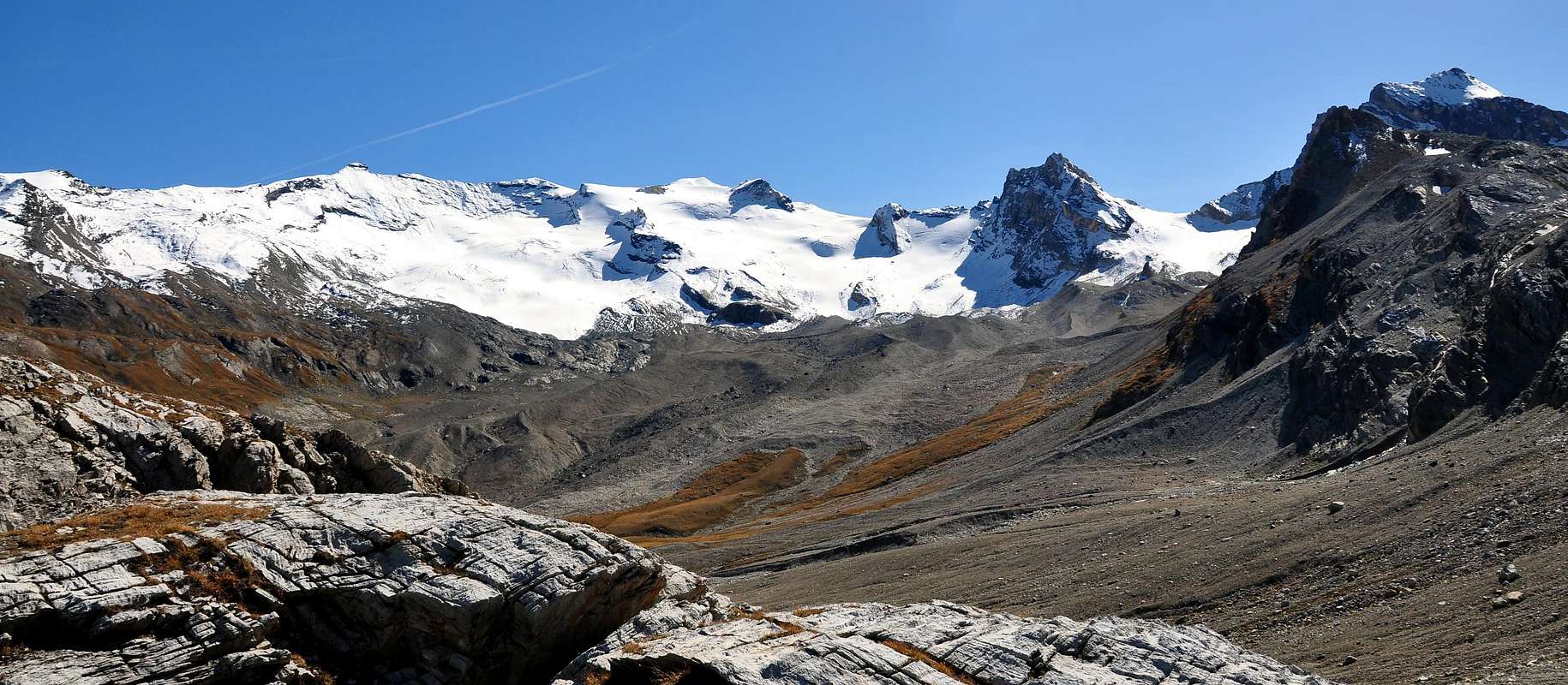
Great mountain in the form of dome (cathedral) in valley head; reduced for Tsanteleina (3.601m), Punta Calabre (3.445m) and Granta Parei (3.387m). Good ascent, but not much popular. Excellent views over Rhêmes Valley and the glaciers.
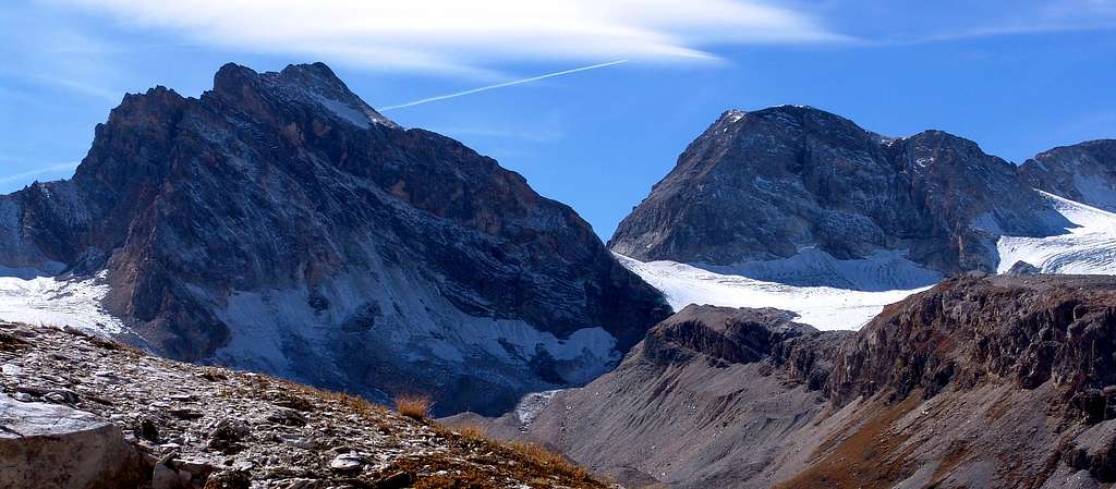
Grande montagna a forma di duomo alla testata della Valle di Rhêmes; ridimensionata dalla vette della Tsanteleina (3.601 m), Punta Calabre (3.445 m) e Granta Parei (3.387 m). Bella escursione, ma poco frequentata. Buon panorama sulla Valle di Rhêmes e i suoi ghiacciai.
This squat and square mountain, when viewed from the front, gains momentum when viewed from the Northeast, where a series of four consecutive elevations (including a first rocky / detrital cone just in left at the base of the true Est-southeastern Ridge) offer the appearance of a large ridge, in miniature on the generis (a little exaggerating) of the Aiguille Noire de Péteurey on Mont Blanc. Next to a very steep and bumpy Eastern Wall rises a daring Northeast Edge, which ends against a large brown-yellowish rocky jump, where the East-Southeast Crest that comes from Col de Fond (3.081m) reaches and joins. The base of the wall is located at an altitude of about 3.015 meters, while that of the edge is located at the junction of the Glaciers Occidental and Central de Fond at an altitude of 2.880 meters around. Ideally, by rotating the view by 90 ° and focusing on the North Face, the aspect, below the aforementioned rocky jump on the E-SE Crest, appears that of a large rectangle surmounted by a final triangle (usually covered with snow, debris and little rocks in terminal part) in the fourth sector below of the Summit. The base of this face balances between approximately 2.955/60 meters in the left sector (East) and approximately 3.010/25 meters in the opposite (West). This first basal sector, the shortest, starts on the Glacier Oriental de Fond at an altitude of about 2.900 meters and consists of a moderately sloping glacial slide (from 28° to 33°) ; it serves as a prelude to the second sector formed by ribs of broken rock on the left and on the right by the end of the large yellow-brownish band that descends diagonally from the third last or penult sector. The Western Side, on the other hand, is "meek and peaceful", showing off a slope on which the last edges of the Glacier de Tsantelèina "climb" and on which the Via Normale climbs. The same is delimited on the left by a "Crestone" NW, which is presented in double face: on the right it is nothing more than the continuation of the previous slope W-NW, while on the left it is suspended over the abyss of the North Wall. From it a long rocky buttress is directed, first to the North-northeast and then to the North, designed to support the Eastern edge of the Glacier de Tsantelèina and at the same time to divide, in the highest part, it from the Glacier Occidental de Fond as well as , in the lower-middle part, from the "Sources de la Doire de Rhemes" with its three little lakes, including the Lac de Fond (2.650/72 m). This rocky bastion ends at the Truc de Saint Hélène (hence the toponym Tsatelèine; 2.640m), right above and in front of the Federico Benevolo Refuge (2.285m). Last but not least, the Southern or French side which is covered by the Glacier de Calabre, which in turn is split in two by a rocky spur which in a triangular little shape projects towards the SW towards the "Gorge du Malpasset ", leaving on the right (East) the French Réfuge de Prariond (2320 m). Coming to the climbs with relative technical difficulties, it should be noted that all the routes in the Northern sector are interesting as well as demanding, unfortunately limited by the poor quality of the rock which tends to flake off with limestone leaves from yellow-ocher to light yellow, in addition to the remarkable suspended material; so much so that there is no repetition of all the routes traced to this day. Analyzing in counter-clockwise sense (unlike the "First Ascents" section which canonically do it clockwise) from the left (East) to the right (West) we find:
1) - a N-NE Edge that climbs up to meet a large rocky jump, which goes around on the left entering the final part on the Eastern Ridge E-SE with which it ends (overall from AD- to AD+ and D-, with passages from II°+ to III°+ and one of IV°-).
2) - The Via Chiara-Bonacossa of August 1939 faces the North Face for the first time, climbing in the left sector (about 450 meters high, including the glacial slide at the base) starting on a sinuous spur with a gray-brown-reddish color and then abandoning it in the midst and moving towards the center of the wall (probably, lacking a specific relationship, from AD to D-/D+, with passages from II° to IV°).
3) - From 20 to about fifty meters on the right the Via Rossi di Montelera climbs with the Aostan guide Beniamino Henry who goes directly over the wall: making more use of the glacial slide at the base, it starts at an altitude of 3.000 meters about, first crosses a band of very broken rocks (II°+/III°-), which lead to a very inclined snowy-detritic ledge; the same anticipates the key passage, where the wall merges into a large groove, characterized by two consecutive dihedrals, that leads to the easy and triangular last sector, formed by snowfields of modest slope, debris and very broken rocks (from AD- to AD+/TD-, with steps by II°+ to V°+ and one through artificial climb, or else also 6b).
4) - "Mixed" route in the right sector zigzagging from right-left-right (West/East/West) and concluding, as well as the previous ones, on Crestone NO. It turns out to be an attempt to overcome the same sector, but which ended with a fall to the right (West) for easier rocks.
5) - For the NW enough long Crest starting at an altitude of about 3.000 meters staying on the edge or just to the right of it and then concluding further South in the final part (F/ F+ with passages of I°+ and II°-, remaining on the thread of the ridge). The other ways, always proceeding anti-clockwise, concern
6) - the W-NW Slope below the Col de Rhemes (3.075m), as well as the extreme Southern margin of the Glacier de Tsantelèina which climbs up to the Summit with an easy climb on ice (do not underestimate the crevasses) and some easy rocks in the final stretch..
7) - As far as the entire Southern sector is concerned, there is no information on the existence of any ascent routes on this long wall of friable rock (about 350/80 meters high); probably, starting from the Réfuge de Prariond (2.320m), the ascent takes place on one of the two hills on the side. Recalling that the first absolute ascent of the mountain was carried out in August 1888 on this side using exactly the Col de Rh & ecirc; mes (3.075m) . Otherwise, and to conclude:
8) - always starting from the Isère Valley, going up to the Col de Fond (3.081m) and making the ascent to the not very easy E-SE Ridge, at times also very exposed, and which presents difficulties AD-/AD with passages up to the IV° on rock, at times, very friable for the length of almost a kilometer with 270 meters of altitude. So, in conclusion, it should be noted that the only route, which is quite popular, consists in the O-NW side, such as to offer a nice ski-mountaineering trip. The rest is left to those young people of good will who still want to discover something ...
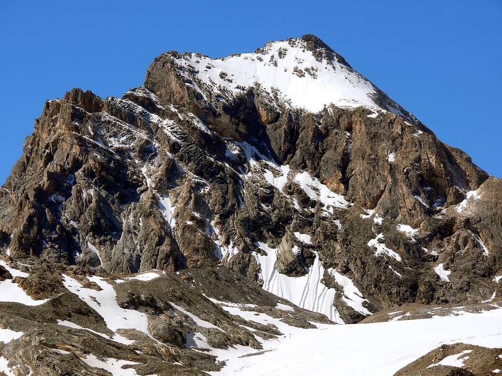
Questa montagna tozza e squadrata, soprattutto se vista frontalmente, prende decisamente slancio se osservata da Nordest, dove una serie di quattro elevazioni consecutive (compresa una prima conoide roccioso/detritica) offrono l'aspetto di una grande cresta, in miniatura sui generis (un pò esagerando) dell'Aiguille Noire de Péteurey. Affianco ad una ripidissima e monca Parete Est, sale un ardito Spigolo Nordest che si conclude contro un gran salto roccioso bruno-giallognolo, dove giunge e si unisce la lunga Cresta Est-sudest proveniente dal Col de Fond (3.081 m). La base della parete é situata a quota 3.015 metri circa, mentre quella dello spigolo suddetto si trova alla congiunzione dei Glaciers Occidental e Central de Fond all'altitudine di 2.880 metri circa. Idealmente ruotando la vista di 90° e focalizzandola sulla Parete Nord, l'aspetto, al di sotto del predetto salto roccioso sulla Cresta E-SE, appare quello di un grande rettangolo sormontato da un triangolo finale (in genere innevato o con tratti detritici e qualche roccetta nel tratto terminale) nel quarto settore al di sotto della Vetta. La base di questa faccia si bilancia tra i 2.955/60 metri circa nel settore di sinistra (Est) ed i 3.010/25 metri all'incirca nell'opposto (Ovest). Questa prima zona basale, la più corta, prende l'avvio sul Glacier Oriental de Fond all'altitudine di circa 2.900 metri ed é costituito da uno scivolo glaciale di moderata pendenza (da 28° a 33°); funge da preludio al secondo settore formato da nervature di roccia rotta a sinistra e sulla destra dal termine della grande fascia giallo-brunastra, che scende in diagonale dal terz'ultimo settore. Il Versante Occidentale, invece, si presenta "docile e tranquillo", ostentando un pendio sul quale si "arrampicano" gli ultimi lembi del Glacier de Tsantelèina e sul quale sale la Via Normale. Lo stesso viene delimitato sulla sinistra da un Crestone NO, che si presenta in double face: sulla destra altro non é che la continuazione del precedente versante O-NO, mentre a sinistra é continuativamente sospeso sull'abisso della Parete Nord. Dallo stesso si indirizza, dapprima a Nord-nordest e poi a Nord, un lungo contrafforte roccioso, atto a sostenere il margine Orientale del Glacier de Tsantelèina ed allo stesso tempo a dividere, nella parte più elevata, il medesimo dal Glacier Occidental de Fond nonché, nella parte medio-bassa, dalle "Sources de la Doire de Rhêmes" con i suoi tre laghetti, tra i quali il Lac de Fond (2.650/72 m). Questa bastionata rocciosa si conclude al Truc de Saint Hélène (donde il toponimo Tsatelèine; 2.640 m), giusto al di sopra ed in fronte al Rifugio Federico Benevolo (2.285 m). Buon ultimo il Versante Meridionale, o francese, che viene ricoperto dal Glacier de Calabre, a sua volta spezzato in due da uno speroncino roccioso che, in forma triangolare, si proietta verso SO in direzione della "Gorge du Malpasset", lasciando sulla destra (Est) il francese Réfuge de Prariond (2.320 m). Venendo alle salite con relative difficoltà tecniche, vi é da osservare come tutte le vie del settore Nord sono interessanti nonché impegnative, limitate purtroppo dalla non buona qualità della roccia tendenzialmente atta a sfaldarsi in foglie di calcari cariati color dal giallo ocra al giallo chiaro, oltre al notevole materiale sospeso; tanto che di tutte le vie tracciate, a tutt'oggi, non si registra nessuna ripetizione. Analizzando in senso anti orario (a differenza della sezione "First Ascents" che lo effettua canonicamente in senso orario) dalla sinistra (Est) alla destra (Ovest) troviamo:
1) - uno Spigolo N-NE che sale fino ad incontrare un gran salto roccioso, che si aggira sulla sinistra inserendosi nella parte finale sulla Cresta E-SE con la quale si conclude (complessivamente da AD- ad AD+ e D-, con passaggi dal II°+ al III°+ ed uno di IV°-).
2) - La Via Chiara-Bonacossa dell'agosto 1939 affronta per la prima volta la Parete Nord, salendo nel settore di sinistra (alto circa 450 metri, compreso lo scivolo glaciale alla base) iniziando su di uno sperone sinuoso dal colore grigio-bruno-rossastro per poi abbandonare il medesimo nella sua metà e spostarsi verso il centro della parete (probabilmente, mancando una specifica relazione, da AD a D-/D+, con passaggi dal II° al IV°).
3) - Da 20 ad una cinquantina di metri sulla destra sale la Via Rossi di Montelera con la guida aostana Beniamino Henry che supera direttamente la parete: sfruttando maggiormente lo scivolo glaciale di base si attacca a quota 3.000 metri circa, supera dapprima una fascia di rocce molto rotte (II°+/III°-), conducenti ad una cengia nevoso-detritica molto inclinata; la medesima anticipa il passaggio chiave, dove la parete si imbuta in una grossa scanalatura caratterizzata da due diedri consecutivi, che conduce al facile e triangolare ultimo settore, formato da nevai di modesta pendenza, detrititi e rocce molto rotte (da AD- a AD+/TD-, con passaggi dal II°+ al V°+ ed uno in artificiale, oppure 6b).
4) - Via "mista" nel settore destro zigzagando da destra-sinistra-destra (Ovest/Est/Ovest) e concludendo, come daltronde anche le precedenti, sul Crestone NO. Risulta come un tentativo di superare il medesimo settore conclusosi però con un ripiegare più a destra (Ovest) per rocce più facili.
5) - Per l'abbastanza lungo Crestone NO con inizio a quota 3.000 metri circa restando sul filo od appena sulla destra dello stesso per poi concludere più verso Sud nella parte finale (F/F+ con passaggi di I°+ e II°- restando sul filo di cresta). Le altre vie, procedendo sempre in senso anti-orario, riguardano
6) - il Versante O-NO sottostante al Col de Rhêmes (3.075 m), nonché al colmo del Glacier de Tsantelèina che lo risale raggiungendo la Vetta con una facile ascensione in ghiaccio (non sottovalutare i crepacci) e qualche facile roccetta nel tratto finale.
7) - Per quel che riguarda l'intero settore Meridionale non si possiedono notizie sull'esistenza di eventuali vie di salita su questo lungo muraglione di roccia friabile (alto circa 350/80 metri); probabilmente, con partenza dal Réfuge de Prariond (2.320m), la salita avviene per uno dei due colli posti lateralmente ad O-NO nonché verso E-SE. Ricordando che la prima salita assoluta della montagna é stata effettuata nell'agosto 1888 proprio da questo lato utilizzando il Col de Rhêmes (3.075 m) e relativa cresta soprastante. Oppure, e per concludere:
8) -, sempre partendo dalla Valle dell'Isère, risalendo al Col de Fond (3.081 m) ed effetuando la salita per la non facilissima Cresta E-SE, a tratti anche molto esposta, e che presenta difficoltà AD-/AD con passaggi fino al IV° su roccia, a volte, molto friabile per la lunghezza di quasi un kilometro con 270 metri di dislivello. Dunque, concludendo, c'é da osservare come l'unica via, abbastanza frequentata (se non proprio popolare), consiste nel Versante O-NO, tale da offrire una bella gita sci-alpinistica. Il resto viene lasciato a quei giovani di buona volontà che hanno ancora voglia di scoprire qualcosa ...
First Ascents
- First on the summit (W Slope from Isere Valley): N. Dulong de Rosnay and mountain guide Victor Mangard, (Aug 12th, 1888).
- In winter: Unknown.
- NW Arête: W. B. A. Coolidge and mountain guide Christian Almer Junior, (Aug 31th, 1889).
- N Face and NW Ridge in final part (Right or "Zigzagging Route"): Osvaldo Cardellina and Marco Cossard, (Jul 07th, 1993).
- N Face and NW Ridge in terminal part (Direct Route): Lorenzo Rossi di Montelera and mountain guide Beniamino Henry, (Jul 27th, 1969).
- N Face and NW Ridge in terminal part (Left Route): Aldo Bonacossa and Giacomo Chiara, (Aug 1939).
- N-NE Edge and E-SE Crest in final part: Osvaldo Cardellina solo, (Jul 24th, 2007).
- E-SE Crest (From Fond Pass): Lorenzo Rossi di Montelera and mountain guide Beniamino Henry, (Jul 24th, 1964).
Getting There
BY CAR:- From France: through the Mont Blanc Tunnel or the Col du Petit Saint Bernard: you can drive on SS.26, following directions for Aosta and, before arriving in Villeneuve, turn right towards Introd. Alternatively, you can take Motorway A5 (at Courmayeur or Morgex) and exit at Aosta Ovest.
- From all the other directions: get to the Aosta Ovest exit of Motorway A5. Then drive on SS.26 Aosta, in the direction of Courmayeur; just after Villeneuve turn left towards Introd.
BY PLANE:
- Aeroporto "Corrado Gex" Saint Christophe (Aosta).
Route
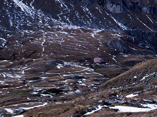
From Federico Benevolo Refuge (2.285m) before after by Northwest direction after South and by path (13 c) to reach to te Granta Parei Lake (2.570m~) and to Tsanteleina Lake (2.696m); by Tsanteleina Glacier to climb by glaciers to Rhêmes Pass (3.075m) and by easy and icy Western Slope to Summit (3h'00/4h'00).Dal Rifugio Federico Benevolo (2.285 m) prima con direzione NW, poi Sud e con il sentiero (13 c) salire al Lago della Granta Parei (2.570 m circa) e al successivo di Tsanteleina (2.696 m); tramite il Ghiacciaio di Tsanteleina portarsi al Colle di Rhêmes (3.075 m) e per il facile e ghiacciato Versante Ovest alla Cima (3h'30/4h'00).
Campings
Remember that free camping is forbidden (except for emergency reasons, over 2.500m, from darkness until dawn).Difficulty
This route can be considered F.L'itinerario è classificato F.
Equipment for the Route
Standard mountaineering equipment. Rope, ice axe and crampons.
 |
Red Tape
The Eastern side of the valley belongs to Gran Paradiso National park, the Western one is out of the boundaries of the Park ... but nature must be respected.Campings
Remember that free camping is forbidden (except for emergency reasons, over 2.500m, from darkness until dawn).Mountain Conditions
- You can get meteo information at the official site of the Regione Valle d'Aosta:
- Valle d'Aosta Meteo
- Meteo: You can find more weather information on the website 3B Meteo:
- Meteo Rhemes Notre Dame
Webcam
- WEBCAM on Aosta Valley:
- Webcam
Books and Maps
BOOKS:- "Guida delle Alpi Occidentali" di Giovanni Bobba e Luigi Vaccarone C.A.I. Sezione di Torino Volume II (parte II), 25 Maggio 1896.
- "Guida dei Monti d'Italia-Alpi Graie Centrali" di Alessandro Giorgetta 1985.
- "Guida della Regione Autonoma Valle d'Aosta" di Mario Aldrovandi, Ed. S.P.E. di Carlo Fanton, Torino 31 Dicembre 1964.
- "Rifugi e bivacchi in Valle d'Aosta", di Cosimo Zappelli aggiornata da Pietro Giglio, Musumeci Editore, Luglio 2002.
- "Diari Alpinistici" di Osvaldo Cardellina e Indice Generale accompagnato da Schedario Relazioni Ascensioni 1964-2019 (inediti).
 |
 |
 |
 |
 |
MAPS:
- Kompass "Gran Paradiso Valle d'Aosta Sentieri e Rifugi" Carta Turistica 1:50.000.
- Enrico Editore Ivrea-Aosta "Gruppo del Gran Paradiso" 1:50.000.
- I.G.C. Istituto Geografico Centrale Carta dei sentieri e dei rifugi "Valsavarenche-Val di Rhêmes-Valgrisenche" 1:25.000.
Important Information
- REGIONE AUTONOMA VALLE D'AOSTA the official site.
- FONDAZIONE MONTAGNA SICURA Villa Cameron, località Villard de la Palud n° 1 Courmayeur (AO) Tel: 39 0165 897602 - Fax: 39 0165 897647.
- SOCIETA' GUIDE ALPINE DEL GRAN PARADISO Comune di Valsavarenche.
- A.I.NE.VA. (Associazione Interregionale Neve e Valanghe).
Useful numbers
- Protezione Civile Valdostana località Aeroporto n° 7/A Saint Christophe (Ao) Tel. 0165-238222.
- Bollettino Meteo (weather info) Tel. 0165-44113.
- Unità Operativa di Soccorso Sanitario Tel. 118.