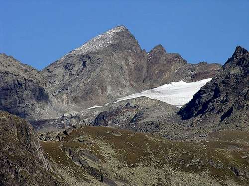
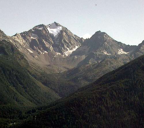
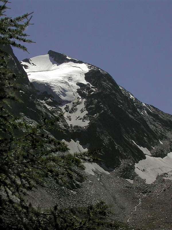
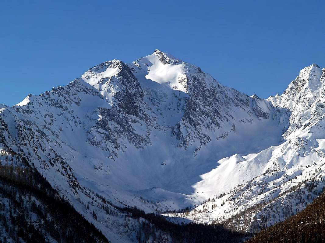
Mont Paramont is a slender pyramid that rises from the Northern Slope of Passo di Planaval. It is the furthest ramification of the Rutor Range. The ridge that divides Valgrisenche from the Valley of La Thuile continues from Paramont summit due northeast toward Torre del Tighet, Torre Tonda, Punta di Faveroy and Monte Colombo. In the northwest direction, the same ridge develops into a spur that encloses a wide, short valley with no outlet, which extends to the ice chute of Monte Paramont. The spur splits shortly before Mont Colmet; the eastern branch descends to Colle della Serra and Passo di Ameran, rises again to Becca Pouignenta, and ends at Monte Charvet; the western branch goes through Monte Colmet, Colle della Croce, and the rolling slopes of Testa d'Arpy. The name "Paramont," which means "covering the mountain", perfectly fits this beautiful and unusual peak, perhaps unique in its form: On the northeast ridge, a massive subpeak at 3.154m suggests the crowding together and mingling of two mountains. Between opposing rock bands, the icy and narrow north face rises most elegantly, broken in the middle by a great ice wall that crosses the face almost from side to side. The terminal chute ends just beyond Point 3.154m; as a consequence, it can be seen also from the distant City of Aosta, while the face itself is hardly visible from the valley floor, because it is partially hidden by a lush forest.
Il Monte Paramont (Parete Nord) bella piramide snella che s'innalza dalla costiera Settentrionale del passo di Planaval, costituendo le propaggini estreme della catena del Rutor; dalla sua cima continua verso nord-est in direzione della Torre del Tighet, della Torre Tonda e del Monte Colombo, la cresta divisoria le valli della Valgrisenche e di La Thuile, ma nel contempo origina verso nord-ovest un nuovo contrafforte (a sua volta sdoppiantesi poco prima del mont Colmet e formanti la cresta che, scesa al colle della Serra ed al passo di Ameran, si rialza alla becca Puignenta per morire infine al monte Charvet per il ramo più orientale e la vetta del monte Colmet, il colle della Croce e gli ondulati pendii della Testa d'Arpy per quello occidentale) che forma un valle larga, corta e senza sbocco, terminante ai piedi dello scivolo ghiacciato del monte Paramont. Il toponimo (monte che ripara il monte, ovverosia che lo copre) calza a meraviglia per questa bella, strana e forse unica montagna nelle sue forme; sulla cresta nord-est infatti una massiccia montagna quota 3.154 m dà l'idea dell'accavallarsi di due montagne che si fondono insieme. Fra le due opposte fasce rocciose s'innalza stretta ed elegantissima la parete nord di ghiaccio, fratturata nel centro da un grande muro di ghiaccio che l'attraversa quasi da parte a parte; lo scivolo finale è ammirabile, poiché sbuca proprio oltre la quota 3.154 m, anche dalla città di Aosta, mentre la parete non è individuabile da La Salle sul fondovalle, poiché occultata da una bella foresta.
First Ascent
First ascent (N-W Arête): Nicodemo Jadanza, (Aug 1880).
S Arête: Nicodemo Jadanza, (1880).
N-E Arête: Emanuele Andreis, Luigi Bon and E. Denina, (Aug 03th, 1927).
Wall N: Pino Formento, Eugenio Bochet and Cesare Quey, (Aug 10th, 1939). * Second: Renato Quendoz and Domenico Chatrian, (Jun 09th, 1968); ** Third: Ilario Antonio Garzotto, Osvaldo Cardellina, Ruggero Busa and Giuseppe "Pino" Trevisan, (Jul 06th, 1969).
S-W Wall: Osvaldo Cardellina, Roy Cardellina and Danilo Garzotto, (Aug 08th, 1993).
N-NW Wall: Osvaldo Cardellina, (Jul 27th, 1999).
Getting There
BY CAR:
From Torino, Milano, etc: Motorway A5. Exit in Morgex.
From Switzerland: through the Grand St. Bernard Tunnel or the homonym Pass.
From France: through Mont Blanc Tunnel or Petit St. Bernard Pass.
BY PLANE:
Aeroporto "Corrado Gex" Saint Christophe (Aosta).
West-northwest Ridge or Normal Route
Approach from Morgex towards La Thuile, La Joux, Refuge Albert Deffeyes: exit of Motorway A5 (921m), continue for about 3 km on SS.26 towards Pré Saint Didier (1.017m). After several hairpins, and past the Villages Elevaz (1.302m) la Balme (1.309m) reach the La Thuile Ski Resort (1.441m). To begin the slope toward the refuge with the path n° 3/15/High Route n° 2 in front of the "Bar delle Cascate", after having gone beyond a bridge in wood on the left and later around 0h'15 you'll come to the First of the three spectacular Rutor Falls. Continue along the path and go beyond (on the left) the Parchet Alp (1.770m) set on the right (South), a first brooklet, the Alp Plan Fruitier (2.810m) and another small torrent, deriving respectively from the Preuvé Comba and from Combassa. To always continue along the path what time it climbs him to terraces and, later 1h'00 the Second Fall is gone beyond, signalled by a panel, but not visible from the path). Later around as many 0h'15 the poster of the Third Fall meets him (1.996m); go up on the steep trail for other 0h'20/0h'30, here the path divides him. Take that on the left (East-northeast) well signalled that it conducts to the hut, after having left (Northeast) immediately towards the entrance into Ussellettes Vallon. To actually go up again to the Collar (2.130m), for then to slightly go down on the right and continue up to the Lake Glacier (2.143m); go beyond the bridge in wood that overhangs the emissary and, leaving on the right the homonym alp (2158m), to start over decidedly climbing along ample and wide hairpin bends up to reach the plateau through a run first semicircular to of it (Northeast) and subsequently toward East-southeast, where site is the shelter (2.494m), not after having just abandoned first to the left (Northeast) the path n°15/High Route n° 2 towards Ussellettes Vallon (E; 2h'45/3h'00 from La Joux).
Route by West-northwest Ridge (Normal Route): from refuge to return back shortly toward of it with the path of the shelter; to advance himself in the Comba (Basin) des Ussellettes with the path n° 15/High Route n° 2 and go up to a carving of the Passo Alto (2.859m). Continuous to, after having gone beyond a ruin, at first with the same direction then folding up more toward East, near the altitude 2.502 meters. Leaving left (North) the steep ramification for the hill, advance himself toward right in a small debris plateau, characterized by the presence of the eight Ussellettes Lochs (2.754m and 2.762m the most greater); after to go up again the inclusive walloon among the Punta d'Invergneures (3.019m) to Southwest and the Testa (Head) of Paramont (3.140m) to of it, but mostly holding herself against this last. With run, that increases in steepness, towards a nocht called Ussellettes's Pass ((2.989m); 1h'20/1h'40 from shelter). From this get on the edge of the ridge with the first part consists of blocks broken and rotten rocks reaching a small wall that will double with a small traverse to the left, easy (I°/I°+), but enough exposed above the Northwest Wall, and then return to the same thread. After some easy plaques or through rock slabs of rock route, you will reach a characteristic hump-plateau just below the Vertex, with the remains of an ancient building perimeter and in short time to the signal and the stone cairn on the same (A/EE/F+; 0h'45/1h'00 by carving; 2h'30/3h'00 from Albert Deffeyes, ex Santa Margherita Refuge).
Monte Paramont W and SW Sides
Avvicinamento partendo da Morgex verso La Thuile, la Frazione di La Joux ed il Rifugio Albert Deffeyes: dall'uscita dell'Autostrada A5 (921 m) continuare per circa 3 km sulla SS.26 in direzione di Pré Saint Didier (1.017 m). Da questo tramite numerosi tornanti e, passati i Villagi di Elevaz (1.302 m) e la Balme (1.309 m), s'arriva al rinomato Centro Turistico di La Thuile (1.441 m), famoso per la pratica dello Sci. Iniziare la salita verso il Rifugio Deffeyes sul sentiero n° 3/15/Alta Via n° 2 davanti al "Bar delle Cascate", dopo aver oltrepassato un ponte in legno sulla sinistra e dopo circa 0h'15 s'incontra la Prima del tre spettacolari Cascate del Rutor; proseguire lungo il sentiero oltrepassando a sinistra l'Alpe di Parchet, situata a destra o Sud (1.770 m), l'Alpe di Plan Fruitier (2.810 m) ed un successivo torrentello provenienti rispettivamente dalla Comba Preuvé e dalla Combassa. Procedere sempre lungo il sentiero innalzalzantesi a gradoni e, dopo 1h'00, superare la Seconda Cascata, segnalata da cartello non visibile. Dopo un altro quarto d'ora circa s'incontra il cartello della Terza Cascata (1.996 m); continuare sul ripido sentiero per altri 0h'20/0h'30 ove questo si sdoppia. Risalire sino al Colletto 2.130 metri, per poi discendere di poco a destra proseguendo fino al Lago del Ghiacciaio (2.143 m); oltrepassato il ponticello in legno sull'emissario e, lasciando a destra l'omonimo alpeggio (2.158 m), riprendere a salire decisamente lungo ampi tornanti fino a raggiungere l'altipiano tramite un percorso semicircolare prima a Nordest e poi ad Est-sudest, dove è posizionato il rifugio (2.494 m), lasciando appena prima il sentiero n° 15/Alta Via n° 2 per il Vallone des Ussellettes (E; 2h'45/3h'00 da La Joux).
Via per la Cresta Ovest-nordovest (Normale): dal rifugio tornare brevemente indietro a Nordest inoltrandosi nella Comba des Ussellettes con il sentiero n° 15/Alta Via n° 2 e salire col medesimo per il Passo Alto (2.859 m). Continuare, dopo un rudere, dapprima con la stessa direzione poi piegando più ad Oriente, nei pressi della quota 2.502 metri, abbandonando a Settentrione la più ripida deviazione pel colle, ed inoltrarsi verso destra in un piccolo altipiano detritico caratterizzato dalla presenza degli otto Laghi di Ussellettes (2.754 m, 2.762 m, i più importanti). Oltrepassatili, salire il vallone compreso tra la Punta di Invergneures (3.019 m) a Sudovest e la Testa del Paramont (3.140 m) a Nordest tenendosi maggiormente contro quest'ultima. Con percorso progressivamente più ripido pervenire ad un netto intaglio, detto Colle des Ussellettes ((2.989m); 1h'20/1h'40 dal rifugio). Salire sul filo di cresta il primo tratto con blocchi e rocce rotte raggiungendo un muretto che si doppia con una piccola traversata a sinistra, facile (I°/I°+), ma delicata e con esposizione sulla Parete Nordovest, per poi rientrare sullo stesso. Superate alcune facile placche o lastronate di roccia rotta, si raggiunge una gobba-plateau appena sotto la Vetta coi resti perimetrali d'un'antica costruzione, donde in breve al segnale (A/EE/F+; 0h'45/1h'00 dall'intaglio; 2h'30/3h'00 dal Rifugio Deffeyes, ex Santa Margherita).
The North Face
From the City of Aosta (583m) take State Route 26 or Turnpike A5 toward Mont Blanc: from Morgex (923m) head for the small City of La Salle, arrived at Le Pont cross the bridge over the Dora in the direction of the Village of Chabodey, and proceed along the country road that runs through the thick forest toward Alpe Lazei (1.515m). But you must park before, not far from Chabodey, since the country road is open only to residents.Continue in the direction of Montagna della Valle (1.815m) and, on easy mule-track, reach eventually Montagna Alta (1.849m). Here the trail forks: a side spur goes on to Gran Bouillon-more precisely to Alpe Leseney (2.095m). Keep on the main trail along the floor of Vallone di Sopra (d'en Haut) until Montagna di Promou (2.018m). This is a convenient bivy place since the upper valley lacks huts adjacent to the pastures. It's about 3 hours from La Salle to here.
The following route description is due to Osvaldo Cardellina and refers to the wall condition in the remote July of 1969. From the pasture continue briefly along the trail, which, after a right turn, ends on the moraine at the foot of the eastern slopes of Chanté Colmet (2.427m). Leave the trail to stay on the valley floor aiming for a small lake (2.123m) in a grassy esplanade strewn with large erratic boulders. Pass the moraine above the lake by just over 200m and proceed straight to the base of the north face. Go up the ice-snow field for about 200m until you are under a rock band, which is roughly 150m tall and abundantly sprinkled by a waterfall. Overcome the cliff on the left, reaching the alternation of snowfields and rock ribs which, after 300m, ends just under the huge serac that divides the face in two. Proceed along the edges of one of the rock ribs (which could serve as shelter in case of icefall) and cross right (west) towards a tiny gully where snowslides are quite common. Climb it quickly, if it is not icy--here the FA party had to cut over 200 steps and use ice pitons--eventually tending toward the orographic right hand side. After about 70m exit to the upper part of the face, which is now significantly less steep. Pass a subsidence and reach the terminal crevasse of the steep final stretch, about 100m high. The crevasse is usually quite open and requires a laborious and delicate crossing. Past this hurdle, aim directly for the summit rock outcrops. (5 hours from Montagna di Promou; 8 hours total). The north face is about 800m tall. In the late sixties the route was rated AD, but the last few hot summers have thinned the great serac and increased the difficulties to D or D+. The danger of avalanches and rock and ice fall has also increased. The slope of the gully alongside the serac is between 50° and 60°.
Descent: from Monte Paramont is usually along the standard route, known as "Route des Ussellettes". This route runs along the rather exposed SW ridge, then, through Col des Ussellettes (3.027m) and Glacier des Ussellettes, leads to the Deffeyes hut at the foot of Rutor Glacier, 800m below the Paramont summit. It is rated E/E, that is, for expert hikers, and is the most popular ascent route to the summit.
Dalla città di Aosta (583 m) si prende la SS.26 per il Monte Bianco oppure l'autostrada A5 fino a Morgex (923 m) dirigersi verso i comune di La Salle (994 m) qui attraversare il ponte sulla Dora il direzione dell'abitato di Chabodey risalendo tra la fitta foresta, la strada interpoderale verso l'alpe Lazei (1.515 m); proseguire quindi in direzione della montagna della Valle (1.815 m) e, sempre su comoda mulattiera, toccare la successiva montagna Alta (1.849 m). Da questo punto il sentiero si biforca inviando un ramo secondario in direzione del Gran Boullon e precisamente verso l'alpe Leseney (2.095 m); proseguire invece sul fondo del vallone di Sopra sino alla montagna di Promon (2.018 m) ove conviene bivaccare, essendo il tratto superiore del vallone privo di baite adibite al pascolo (ore 3h'00 da La Salle). Dall'alpeggio proseguire per breve tratto lungo il sentiero che, svoltando a destra va a morire sulla morena alle pendici orientali della Chanté Colmet (2.427 m) per abbandonarlo presto continuando sul fondovalle in direzione di un piccolo laghetto (2.123 m) posto su di una spianata erbosa con grandi massi erratici; superare per poco più di 200 metri la sovrastante morena e portarsi direttamente all'attacco della parete nord. Risalire un gladio-nevaio per circa 200 metri portandosi a ridosso di una fascia rocciosa alta circa 150 metri, caratteristica per una cascata d'acqua che la innaffia abbondantemente. Superare sulla sinistra il salto portandosi sui nevai alternati a crestine rocciose che, dopo circa 300 metri vanno a morire proprio sotto il grande seracco che divide in due parti la parete. Proseguire lungo i bordi di una delle crestine rocciose (che potrebbero costituire riparo in caso di caduta di ghiaccio) e attraversare, verso destra (ovest), in direzione di un minuto canalino soggetto alla continua caduta di slavine. Superarlo velocemente se non ghiacciato (in questo tratto i primi salitori furono costretti ad intagliare più di 200 gradini e ad usare chiodi da ghiaccio) piegando eventualmente lungo la sua sponda orografica destra; dopo circa 70 metri uscire nella parte superiore della parete, che diminuisce alquanto di pendenza. Superare un avallamento portandosi alla crepaccia terminale del ripido tratto finale alto circa 100 metri; in genere essa è alquanto aperta e costringe ad un faticoso e delicato travalicamento, dopodiché si prosegue puntando direttamente alle roccette terminali (ore 5h'00/8h'00). La parete Nord è alta 800 metri circa. Alla fine degli anni 60 le difficoltà erano state valutate AD, ma ora che il grande seracco si è assottigliato le difficoltà sono aumentate da D a D+. Notevole è il pericolo di valanghe di roccia e ghiaccio. La pendenza del canalone è compresa tra i 50° e 60°.
Discesa: lungo la via normale, noto come "Route des Ussellettes". Questo percorso si snoda lungo la cresta SW ed è piuttosto esposto, è valutato EE per escursionisti esperti.
Gear
Mountaineering equipment including ice axe, helmet, crampons, rope, ice screws, and carabiners.
Da alta montagna, corda, casco, piccozza, ramponi, chiodi da ghiaccio e moschettoni.
Campings
Remember that free camping is forbidden (except for emergency reasons, over 2.500m, from darkness until dawn).
Mountain Condition
Meteo: you can find all the needed informations at the official site of the Valle d'Aosta Region:
"Guida delle Alpi Occidentali" di Giovanni Bobba e Luigi Vaccarone C.A.I. Sezione di Torino Volume II (parte II) 25-05-1896.
"Guida della Regione Autonoma Valle d'Aosta" di Mario Aldrovandi, Ed. S.P.E. di Carlo Fanton Torino 1964.
"80 itinerari di Escursionismo Alpinismo e Sci Alpinismo in Valle d'Aosta", di Osvaldo Cardellina, Ed. Musumeci, Giugno 1977 (in Italian); seconda Ed. Luglio 1981; terza Ed. Luglio 1984; (in French), prima Ed. Febbraio 1978; seconda Ed. Marzo 1980.
"Guida dei Monti d'Italia Alpi Graie Centrali" di Alessandro Giorgetta - Club Alpino Italiano-Touring Club Italiano, 1985 (in Italian).
"Ascensioni 1964-1969" Diario Alpinistico di Ilario Antonio Garzotto (unpublished).
"Diari Alpinistici" di Osvaldo Cardellina e Indice Generale accompagnato da Schedario Relazioni Ascensioni 1964-2019 (unpublished).
MAPS:
Kompass "Massiccio del Monte Bianco Valle d'Aosta" sentieri e Rifugi Carta turistica 1:50.000.
Kompass "Gran Paradiso Valle d'Aosta" sentieri e Rifugi Carta turistica 1:50.000.
L'Escursionista "La Thuile-Piccolo San Bernardo" Carta dei sentieri (n° 2) 1:25.000.
Enrico Editore Ivrea-Aosta "Gruppo del Gran Paradiso" 1:50.000.
I.G.M. Istituto Geografico Militare Maps 1:25.000.
Parents refers to a larger category under which an object falls. For example, theAconcagua mountain page has the 'Aconcagua Group' and the 'Seven Summits' asparents and is a parent itself to many routes, photos, and Trip Reports.

 17825 Hits
 95.01% Score
 50 Votes