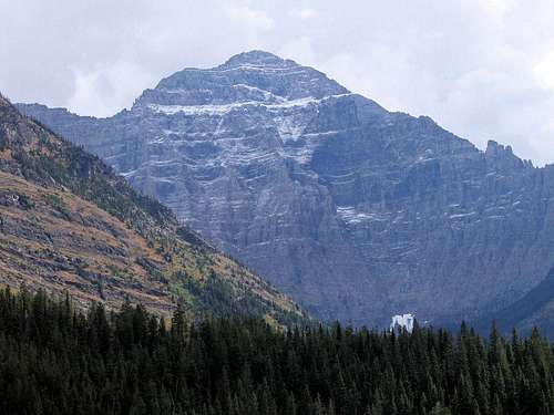
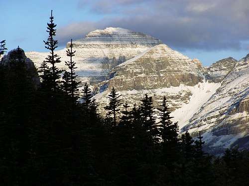
Near Goat Haunt, a good light illuminates Mt. Cleveland in a kind way.
Played out against the backdrop of Glacier National Park, MT.
PARTICIPANTS:
The Trail from Goat Haunt Ranger Station to Stoney Indian Lake—8.5 miles
Stoney Indian Pass (6,908')
The Stoney Indian Peaks Traverse—High Point, Approx. 8,600'
The Stoney Indian Peaks—Highest peak, 9,350'
Mount Cleveland, highest point in GNP (10,466'—elevation gain from Goat Haunt: 6,250')
To begin: One of the north face, one from the south.
No person who has yet to discover some of the pleasures of climbing can possibly realize the intangibles associated with a day on the mountain. —J. Gordon Edwards
The launch point...
Although there are other routes, the goat-trail traverse across the Stoney Indian Peaks is the most scenic, shortest, and easiest way to do it. After crossing from the U.S. into Canada, taking the launch from the Waterton Townsite, then re-entering the U.S. at Goat Haunt, it is the most fun for your time. Besides, on the way across the eight miles of Upper
International Boundary
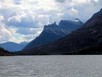
Waterton Lake, among other nice things you get your first view of the famous and infamous Mount Cleveland North Face. So if you weren't psyched before, things are definitely improving, because you are now looking 6,000-and-some feet up to a summit not really all that far away, of which about 4,500 feet are precipitous and vertical, will do a number on you; trumpets blow in your mind, you want to scream at everyone else on the boat to "Look, look at that! For crying out loud, will you just LOOK!" But whatever else is going on in your head, no matter how the band plays, there is just this huge, gigantic monster-of-a-mountain sliding quietly through the view before the boat. Sitting there, silently doing its thing, while you go berserk at the unreasonable, incongruous size of it all.
And then there's this thing called the north face, the greatest sudden piece of vertical topography in the lower 48 states. —from Climber's Guide to Montana, by Pat Caffrey.
Mount Custer.
But the boat moves down the lake through a mountain paradise, and it is not all Mount Cleveland. Water and forest and many, many mountains carry the spirit of the day; the wildness is a good thing to enter, and at the south end of the lake we do so. Disembarking and customs intrude on eagerness to really get under way, but eventually, with words of warning about, "the first thing you do at camp is not set up your tent, but hang your food," flitting through our minds, we enter the wilds in search of the great peak.
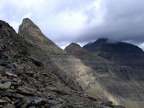
Citadel Spires, Citadel Peak.
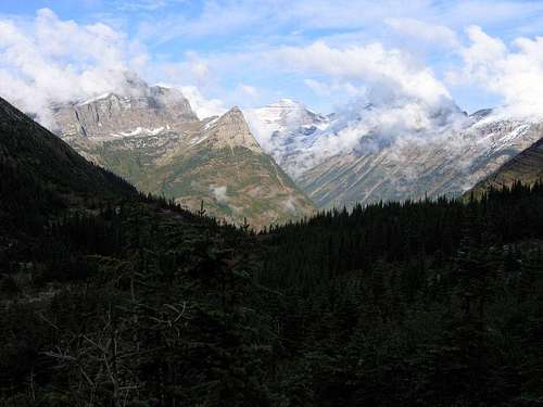
Our trail will take us to Kootenai Lake, a few miles later to Stoney Indian Lake, and then 600 feet up to Stoney Indian Pass, where we will leave the trail and be on our own—finally!—just us and the Stoney Indian Peaks, and more than anything at that time, all thoughts, all focus, will lead to Mount Cleveland. Mount Cleveland. The words conjure up mental images. In 1969, five very talented, experienced Montana climbers attempted the first ever climb of the North Face—and did so in late December. They had done a great deal of research, picked the brains of the back country rangers as to whether or not such a feat was even possible (the rangers, to a man, said it was too dangerous, and recommended against the attempt). Nevertheless, they knew, or thought they knew, exactly what they were getting into, and so went ahead. All five were swept to their deaths in an avalanche, with three not recovered until the following spring. The North Face wasn’t first climbed until several years later—by, among others, a brother of one of those lost in the earlier attempt—and has even now only been climbed two or
South end of lake.
three times (I only know of two times for sure). And more recently—not as overtly dramatic, but just as deadly—an individual, trailing behind his partner during the traverse part of the descent, took a misstep, and fell to his death.
This mountain, highest point in a great area, is a huge thing not done in a single day, and most assuredly is not for beginners; yet in good weather it is not technical, so with determination and effort the possibility is there for the ordinary climbers among us to wrap ourselves around the idea of the summit, and go for it. And then one spends almost as much time via goat-trail traversing to actually reach the mountain as is spent on the mountain itself.
It has taken on a kind of mythical status in the Glacier Park area. While I was picking up our backcountry permits, a ranger told me of a party that couldn’t summit, not due to weather, or time, or any physical inhibition,
A wonderful place for a ranger station!
but because "...there were six or seven grizzlies on the summit." And I have two friends that were the first on top in 2006 (mid-July, which is when access normally opens), and actually had to "chase" two grizzlies off (meaning they got their bear spray out, yelled and screamed at the top of their lungs during the last several hundred feet, and the bears chose to leave). The summit is a dinner table for bruins—filled with cutworm army moth larvae and lady bugs—a real feast! Mount Cleveland’s summit is bear infested!
It also is a member of the ultra-prominence club. Bob and Duane have set this peak, from the very beginning, to be the last in their conquest of all 58 such in the Continental U.S. If we are successful they will become the first to complete the above number, which in itself is something to be proud of, but in this case is extra special because the two of them did pre-eruption Mount Saint Helens, which after the eruption is no longer an ultra-prominence. The ultra-prominence quest has been reduced to 57: Bob and Duane, if successful, will be the only climbers to do 58—ever (and if some ambitious, intrepid, individual who has also done the pre-eruption St. Helens, decides to pursue the magical
Looking north into Waterton from Goat Haunt.
"58"...well, at the very least my two friends will have done them first—which is always bragging-rights leverage, of sorts). In a two-for-the-price-of-one arrangement, we are also attempting the county highpoint of Glacier County, Montana. Bob and Duane do county highpoints, as well. (Bob and Duane get into lists....) So, from the get-go this ascent has innuendo and extra curriculum intent. I want to do the thing because I’d like to do all the GNP 10,000 foot peaks (but I, of course, am not into lists—that stuff is for my friends out on the fringe). Finally and actually...for all of us there is another reason: nice mountain, nice country. So the reality is that as we set off, this naturally huge mountain is even larger than that in our minds. To cut to the chase: it is quite a special place. Let's go!
Who's watching who here?
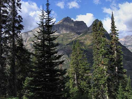
There are several launch excursions during the day, and as ours left Waterton Townsite in the early afternoon, we set our initial day's hike as an easy 2.5 mile jaunt to Kootenai Lake. At first the forest was relatively open, with occasional glimpses of the surrounding mountains, but that soon changed to the relatively dense growth typical of this part of the northern Rockies. The trail was good—and indeed, remained so all the way to Stoney Indian Pass (rule of thumb is that most Park Service-maintained GNP trails are excellent)—and for this first short jaunt of the trek, relatively flat. The ranger checking us back into the U.S., and with whom we registered our itinerary, warned about a couple black bears frequenting the area, and soon after leaving the Goat Haunt Ranger Station we did indeed come across bear scat on the trail. Fresh bear scat on the trail. Then, not much further on, more fresh evidence of a berry-laiden diet! Pretty gross, actually; I mean, some unwary hiker could actually step in the stuff, and end up with a REALLY smelly tent. I think I'll write a letter to the GNP Superintendent and complain that that stuff should be cleared off the trails. Or maybe they could just train the bears better....
Kootenai Peak, Kootenai Lake, Moose; all capture the day's last light.
Anyway, fresh bear scat always makes it easier to yell. So we did just that, eventually arriving (after a neat encounter with a pine marten that scampered up a tree, then spent a couple minutes watching us watch him) in one piece at Kootenai Lake, where we encountered the first of GNP's back country idiosyncrasies, in the form of a Food Preparation Area set maybe 40 or 50 yards from the tent site. No food in tents, or even close—none whatsoever. Ever. Absolutely no cooking around tents—not to be considered in any way, shape, or form (and of course, no campfires). ALL food must be either hung, or in a bear canister (the Park Service will supply you with a free canister if you'll be camping above timberline, and no hanging poles have been installed). Even such non-edibles as toothpaste or lip balm are to be hung. It just takes one instance of a bruin coming into contact with easily-obtained human food (and a bear's definition of "food" isn't always the same as ours), and...you have a problem bear. The folks managing this area are so serious about limiting the possibility of bear/human contact that it is like a mantra with them: "the first thing you do upon reaching camp is not set up your tent, but hang...your...food." The week prior to our venture, a grizzly had invaded a camp in a different part of the park while the occupants were cooking dinner next to their tent. Bear got the meal, occupants got terrified, bear investigated stuff in the tent, Oldman Lake backcountry site now closed to the public, bear and campers both on serious probation. That's good enough for us: we'll be glad to use the food prep area for storage and cooking, thank you!
Citadel Spires at twilight.
Kootenai Lake is idyllic. A large body of water nestled in the forest, with Kootenai Peak drawing your eyes as it towers at the far end; other (unnamed) mountains and ridges closer. Quiet, peaceful, and after doing all the requireds—hanging our food, setting camp, eating, rehanging our food (okay, okay, that’s enough with the hanging the food thing; at this point you either get it or don’t, or won’t)—it was nice to take a short walk along the shore. The moose prints in the damp soil at the lake’s edge were mute testament that this country is well populated by non-humans, and indeed, as we experienced the twilight a couple moose came out on the far side of the lake, and began feeding. It is noteworthy that one of the individuals we were to meet over the next couple days had counted between eleven and fourteen moose around this lake one evening! I’m not exactly sure what constitutes true wilderness, but having a lot of moose around does seem to fit into the equation.
Moose and calf.
The next day was to take us the remaining six miles or so to the Stoney Indian Lakes backcountry site, and whereas the first day had been relatively flat, this day would find us climbing about 2,000 feet to camp, of which most would be done over the last 2.5 miles. The trail, while not so flat as the previous day, was still something could only be called “easy,” but then the last half kicked in, proving to be a very steady, unrelenting climb. So we did it—the entire six miles—in fine style, eager to set camp and begin a reconnaissance for the next day’s climb of Cleveland. Well, actually...while it turned out we made overall good time to camp, we did make one little, unexpected, discovery on the way which held us up just a bit, and that is that moose, up close, are really BIG.
Final ascent to the lake, Kootenai Peak behind...
Bob claims that he somehow managed to ruin his bear spray holster, so his canister wouldn’t be readily available in an emergency (any time you need bear spray it’s an emergency), but that maybe I should take the lead, and thus hold off any oncharging wild beast until he could drag his spray out and render assistance (uh-huh). (And we wouldn’t dare put Duane in front; we’d not see him again until camp!) So I was leading (quite alertly and courageously, I might add) through this wild fierce-beast-inhabited country, when who should I meet coming around a bend in the trail but a little moose. The first thing that happened is that we both immediately stopped and looked at each other. I took the opportunity to call out, "there’s a moose"—pretty original, huh?—whereupon the three of us had a brief glimpse of the little fellow hightailing it into the trees. The thing, of course, is that little moose don’t travel alone, and the next thing I saw was this not at all little moose running onto the trail between where her calf had been, and us. She was maybe twenty or thirty yards away, very big, and every fiber of her being was letting us know that she was unhappy we were where we were—that is, too close to her offspring.
Citadel Peaks, Citadel Spires—all are part of Porcupine Ridge.
For those of you not knowing it, moose are very unpredictable, naturally a bit irritable, not afraid of anything (a healthy adult has no natural enemies), and quite dangerous. They are not like a grizzly in that an assualt may well turn out to be a bluff charge; there’s no bluff in a moose charge, it’s an attack with intent to not maim or scare, but kill. If a moose comes at you, you are in a lot of trouble. At the time, all this was going through my mind, and I was remembering that bear spray will sometimes work on other critters besides bruins, but was saved from having to find out because mom ran into the forest after her baby. But she didn’t go far, and we could see her standing behind some trees, still quite close. I think Bob and I both said at about the same time something to the effect of "let’s get out of here." Which we did, and were only too happy to do so. THEN, the rest of the way to Stoney Indian Lake was, I’m happy to say, quite uneventful, except for the routine, obligatory grumbling about the constant climb. And we met some folks on the trail with whom we swapped moose stories.
Kootenai Peak.
It's there if you need it...
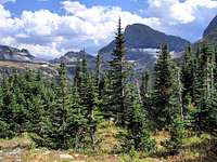
The Stoney Indian Lakes site is quite nice, with a good camping area, food preparation area (it even has a bear-proof food storage facility at ground level, plus the usual backcountry site food hanging apparatus), the most amazing pit toilet I’ve ever seen (I consider these things an idiosyncrasy, but Bob says they’re not really all that unusual in his normal haunts—the North Cascades—and that I’ve just never seen one before, but look at my hauntingly great picture and judge for yourself; at least you have a view to contemplate while you’re sitting). The lake itself is nice (I’ve never met a mountain lake I didn’t like, whether in GNP or elsewhere—they’re all nice; I think it’s a mountains and lakes rule), with the trail leading around the lake, then immediately switchbacking up the approximately 600 feet to Stoney Indian Pass.
Stoney Indian Lake.
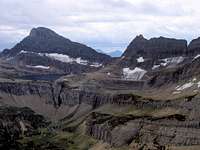
We quickly pitched our tents, then headed up the pass to check out the next day’s route around and through cliffs. And let me say it here, to get it out in the open for visual intake and dissemination: Stoney Indian Pass is one of the great ones. It is a member of those special vistas that, no holds barred, will blow the top of your head off. Coming up the last few feet of trail to reach the crest and see what had until then been hidden from view proved, at least to this climber, to be one of those moments that makes a day amongst the mountains so special. It is not something you forget. One word coming to mind—actually, slapping me in the face—was...DRAMATIC! Well, we soaked in the view (made even better by the interplay of clouds and lighting) a while, then left the trail for our first on-site investigation of the route leading to the reason for this trip in the first place.
The view begins opening up.
The traverse plainly visible.
Climbing—just above Stoney Indian Pass.
Never forget that what is a weak weather system in the valleys and plains will be an entirely different circumstance at elevation.
Stoney Indian Pass, #1.
Stoney Indian Pass, #2.
Stoney Indian Pass, #3.
View from the high point of our reconnaisance.
I think it is safe to say that all three of us are glad we made the effort to explore the initial off-trail scramble. There were a couple cairns not really helping all that much, an occasional spotty trail, but mostly it was just scree and working through cliffs to what might be described as a common-sense solution. If we reached the correct elevation it would be a simple matter to scramble over the top of the cliffs, and onto the goat trail—the well-known traverse leading across the flanks of the Stoney Indian Peaks, to eventually reach Mount Cleveland itself. Coming out at the wrong point would mean having to retrace our steps, with much loss of time and
At the time, we didn't realize what this meant...
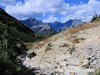
energy. In some respects, this was the most physically taxing part of the climb, as loose rock and scree were persistent, making footing both uncertain and effortful, and there were enough cliffs around that even though when viewed from the lake it had been quite clear where the traverse began, being on the slopes leading to our entry point was not as simple and straightforward—far from it!—as had appeared from a distance. So it was good we did the preliminary investigation of that first thousand feet from the pass up to the "correct" cliffs, which not only let us know about the kind of terrain we’d be dealing with the next morning, but also provided a good idea of the location of our entry point to the traverse.
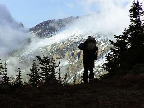
We paused often during the descent back to camp, again marveling at the drama on display in this incredible arena, as the mountains around us were a marvel of rapidly changing light and clouds. We even had clouds rising out of the depths, coming from below to curl around, as though playing with, the walls and peaks before us; the wind became a bit chilly, but all in all, what we were experiencing could only be described as wonderful! And although we didn’t realize it at the time, with this changing, mesmerizing drama and beauty, summit day began to unravel on us.
Searching for the traverse, #1.
Searching for the traverse, #2.
Anticipation for the next day’s climb ("Mount Cleveland!" "Summit!" Finally, those three words to come together!) was keen, so it probably comes as no surprise when I say that spirits were high, and despite a chill wind and gathering clouds, dinner that evening was an interesting, good-humored affair. A pleasant side effect arising from having a specified space in which to prepare food is that all campers cook in one relatively small area, and since climbers and hikers in this rather rarefied atmosphere have a tendency to be outgoing and gregarious, discussions among strangers are frequently noteworthy and lively. The previous night we’d encountered two
Searching for the traverse, #3.
Searching for the traverse, #4 (pointing the way).
men from Washington who were able to match Bob’s and Duane’s "Prominence Enthusiasm" with something of their own—which could maybe be called "Bushwhack the entire circumference around the bases of all the major Washington and Oregon volcanoes Enthusiasm." (It is my suspicion the four of them were sincerely impressed with the insanity of each other!) And this evening (that is, the second night) found Bob in his element because there were two hikers from Georgia that actually—on first hearing, no less—understood, and enjoyed hearing about, the joys and necessities of Ultra-prominence Pursuit. Of course, one of them was a psychologist, and the other a neurologist—who admitted to having a collection of over six thousand comic books!—so perhaps it was a case of obsessive compulsives finding comfort in kindred spirits with like derangements. All in all, the outdoors does make for strange camaraderie! I felt like the only normal one there.
And everyone was interested in our climb of Mount Cleveland. Which begins...now.
Summit morning did not dawn bright and cheerful, but somber, overcast; cool, but I don’t recall it being unduly cold; just gray with said grayness looking to contain somewhat more water than was really necessary. The
Mount Kipp, Sue Lake...
preceding afternoon’s wonderful play of light, with clouds boiling up from the depths, had been the lead of a system we’d been watching for the past week or so. Not much of a front, really, at least in the valleys, but the word was that Lethbridge (AB., and out on the nearby plains) may well have high temps only in the 50’s, so we had watched, spoken with the rangers, decided there was nothing to be done about it, and since nothing predicted was "major," went ahead. After all, planning on this outing had been ongoing for the entirety of last winter!
Information gleaned from previous successful parties showed that summit day on Mount Cleveland usually takes around ten hours, so with threatening conditions all around (but with the hopeful assumption it meant nothing more than repeated showers moving through) we headed for Stoney Indian Pass, pausing briefly to watch a solitary loon puttering about in the lake—a small, lonely thing in a body of water reflecting the grim sky! The pass was easily reached, at about the same time we were hit with cold wind and rain (although not really a lot of the latter, which was definitely encouraging), and since we were nearing timberline, decided to wait out the shower while there were still trees for shelter. The shower had its way with the world for about an hour, then moved off, and, optimistic at the improving weather, we began the climb in earnest.
We finally reached the goat trail—but before continuing, the view took priority...
Bob leads the way onto the goat trail.
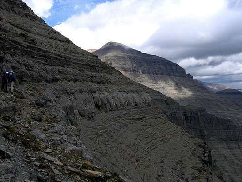
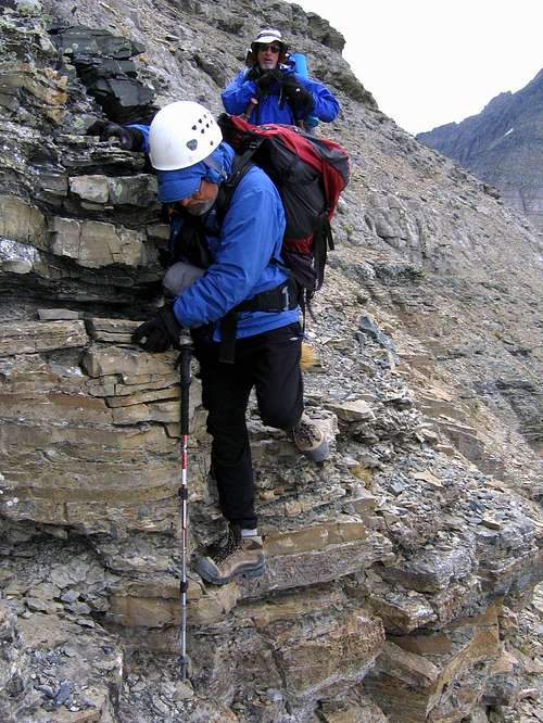
At first it was easy to simply retrace our reconnaissance steps from the day before, but it soon became obvious that we needed to go a bit higher so as to come out above the cliff, thus correctly encountering the goat trail, and beginning the traverse. It looked so simple from camp, but as with all things mountaineering, distances and obvious routes are often deceiving, with the up-close reality being quite different. Bob and Duane are wonderfully adept at using a GPS, and in this instance those abilities proved to be quite the time-saver, as by comparing way-points from the previous day, and checking elevation, we were able to follow, or intelligently deviate from, the route as had been envisioned on our scouting excursion. This first, scree-laden portion of the climb, is not at all pleasant—and the danger of rock fall is extreme—but cannot be avoided, so we kept at it, and on our first attempt (good job, Bob & Duane!) walked across the top of the cliff, saw a cairn, saw the goat trail immediately before us, and the great traverse to Mount Cleveland began.
Almost at the notch, this cliff traversal got our attention!
Couloir comes into view.
For those of us doing much climbing in Glacier National Park there is a saying, which although it varies a bit from individual to individual, goes something to the effect of, "If you’re really lost, really desperate, follow the goat trails. Trust them." Sounds silly, of course, and sometimes
Couloir and notch.
there's no denying that it is...but not always. A couple of the greatest trails in the park are the result of goat engineering. We were now on one of the best (another is the stupenduous Ptarmigan Tunnel to Ahern Pass Goat Trail, which is so incredible it was selected to begin the GNP page), and why the goat hierarchy chose to put a trail through this particular lay of the land is a well-guarded secret, but every individual using this route (which is by a huge margin the ascent of choice) needs to put a block of salt in the goat tip jar (goats love salt), and be thankful for not so small favors.
Last view west for a while...
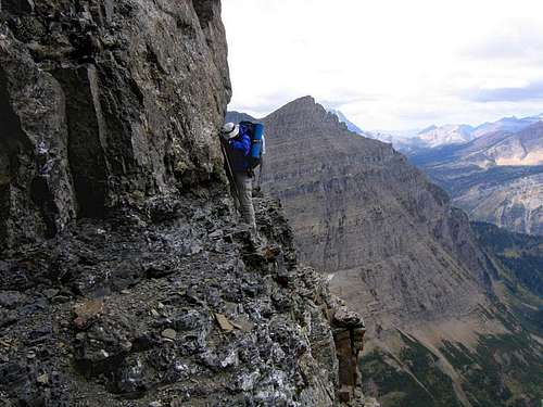
With what seems at times to be the entire world at your feet, this traverse is everything! Walking, walking, walking—gradually, easily ascending, but such ascent not noticed because the view, the thought of what lies ahead, are spellbinding. Sometimes it is just a trail on the side of a mountain, other times cliffs insist on a substantial concentration of effort, with decisions needing making as to whether creeping over a cliff face is doable, or take the extra time to descend, with the necessary climb back to the trail. And there is no avoiding it—sometimes you will confront exposure. And always the views are unrelenting, views to die for (that can be taken literally, if you are not careful). Well, we did the first part of this goat thing, maybe a quarter of it, then came to the couloir (easily visible from our camp, now about 1,900’ below), up which we had to scootch so as to make the ridge top, crossing over to then continue our traversal, but now on the other side of the Stoney Indian Peaks. Extreme caution was called for here, because the couloir, while not extremely steep (although enough so to be interesting), is full of loose rock of a serious nature. We pulled up and through that crack in the ridge without mishap, pulled ourselves out atop the ridge...and there, blessed image before our eyes, visible—finally!—for the first time since shortly past Goat Haunt...was Mount Cleveland. What a wonderful sight, and for a short while there was nothing else to the world!
Climb the couloir, cross the ridge: First view of Mount Cleveland!
I don't know if someone spoke aloud, or if it came from a collective thought between the three of us, but the majority of the traverse, and the more dangerous part at that, still lay before us; once we were able to get past the immediate sensation of actually seeing our destination right there, for crying out loud! we realized that "right there" was actually a substantial traversing distance away (J. Gordon Edwards' A Climber's Guide to Glacier National Park says that at that point it is about two miles); enjoyable as it proved to be just standing, looking, being within reach of our objective, it was still a ways, so we needed to be on our way.
On the traverse.
A good perspective of where we'd just been.
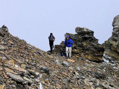
Bob & Duane moving along (enlarge this).
Our surmounting the ridge had put us on the east side of the Stoney Indian Peaks, and it soon became all too apparent that, for lack of a better way to say it, the weather looked different over here. After our earlier waiting out the shower, the sky had lightened, and been encouraging, but not so on this side; there were more and heavier clouds in the distance; certainly something to note, but at the moment not all that threatening. The saddle ending the traverse and leading onto the mountain proper, was about an hour away, looking to be a good spot for lunch, and gathering ourselves for the final effort.
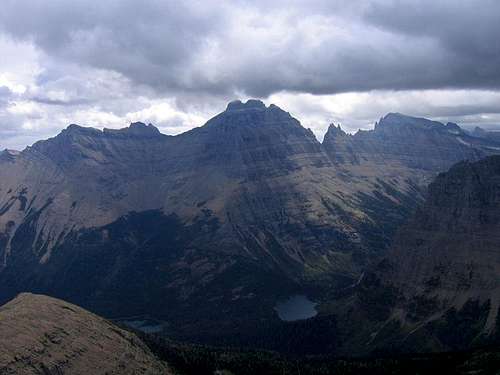
Mount Merritt, and over 5,000' down to Mokowanis Lake...
Chief Mountain, Cosley Ridge, Glenns Lake.
Now this telling becomes difficult. The day—this great, grand day!—merges, draws itself into an emotional mishmash of things not right, as what was to have been a traverse to a great mountain began descending to the impossible. Don’t misunderstand, we did that wonderful, airy traverse, happily moving toward Cleveland; happily walking to where a short ridge led onto the mountain. Easily (but carefully!—and not nearly as easily as the mountain goat we watched run over the cliffs above us; I suspect he was marveling at our clumsy efforts, and showing off, which really wasn’t necessary, and if he slipped I was all set to laugh at him...he didn’t
Approaching the ridge providing entry to the mountain.
over, under, and alongside cliffs and air...drawing steadily closer to day’s end. We finished the traverse, stopped as planned under some protective cliffs at the saddle’s edge—and it all came to an end.
What happened is only too simple to describe. We were sitting with our backs against the cliffs, which provided protection against a strong wind, munching lunch, gathering strength for the last push to the summit, when it became apparent the clouds wrapping around neighboring mountains were considerably closer than had been the case even an hour ago. In a way it was beautiful; we were thousands of feet above the valley below, and could see a wall of clouds slipping out from behind mountains, as though done with hiding they were ready for an all out assault. And they came, from the side, from below, moving closer, seemingly gaining speed during the advance, until they were on us, blotting out the world, and all we could do was wait, and hope the experience was that of a passing shower. It began to rain, then hail, then hail mixed with snow, and it was not a passing thing, but the beginning (although the realization of such was not immediate, taking a short while to sink in) of hours and hours of what may have been nothing on the plains but was everything for us.
At this point, all we could do was watch...and hope for the best.
I too have replayed the day trying to figure out what we could have done differently to have gained the summit. I keep coming back to being thankful that we got off alive. A couple of hours later on those ledges could have created a slippery tread and a fatal fall. Besides, it’s a great place to visit again. —Duane Gilliland
And a few minutes later...no entry. Turned back.
Starting back...
Then the door closed—irrevocably and with finality—on the day: lightning...and the deadbolt slammed home. No entrance here! Lots of lightning, the kind that you see the flash and there is no pause before the thunder; the sort of thing that really, really, REALLY gets your attention in a big, immediate way. The kind of thing that scares the hell out of you, and makes you small and vulnerable inside, and ends climbs—and easily does all this at the same time. You don’t argue with lightning. We were caught in bad weather on a high place, and so turned back, through the limited visibility and gathering snow. Turned back, turned away from Mount Cleveland and just 1,700 more feet elevation gain to the top of Glacier National Park. Through the cloud, over a rapidly slickening goat trail, fleeing the lightning and thunder and awful conditions coming from the sky. Some mountains are worse than others to be caught on in bad weather, and Mount Cleveland is one of the bad ones. We couldn’t run, could do nothing but slowly, carefully, retrace our steps. Which we did. I guess you could say we fled slowly.
I’ve never been sorry that we turned around, but I’ll always be sorry that we didn’t make the summit. —Bob Bolton
Fog...snow...caution...
Our retreat took us not down, but across; in bad weather circumstances such as that in which we now found ourselves, the normal, natural, and no doubt wisest outlet is usually to head down, but the terrain we were currently moving through wouldn’t allow it—heading down just wasn’t possible. So, unable to descend, we once again did the traversing goat trail, and now, and seen in retrospect, perhaps we caught a break. Being on the east side of the Stoney Indian Peaks gave us shelter from the worst of the wind, which had been quite strong as it whipped across the saddle just a few feet from where we lunched—and equally treacherous on the exposed ridge we would have taken on the mountain itself. And the lightning moved in and out around us; sometimes there was little or no time lapse between flash and thunder, other times it wasn’t quite so close, and as the afternoon progressed across this exposed place, gradually lessened, eventually ceasing altogether. The worst, then, was that the snow and hail were accumulating, enough so that footing would rapidly become a serious issue. Plus, we were moving through a cloud, and while fog is nice for a pleasant stroll through your city park, is not necessarily all that nice on narrow, exposed, slippery ledges at elevation!
I think this captures the mood we all felt at the time.
Checking out the couloir descent.
But it could have been worse. Lightning didn’t remain constant, snow was still relatively light, wind was (thankfully!) not an issue in the shelter of the mountain, and visibility, while certainly limited, could be dealt with. And we all had plenty of clothing to put on. So it became a matter of carefully, carefully putting in time on the trail. And that is how we did the traverse. Slowly, carefully, the thought of what we’d lost looming huge—and now not visible—at our backs, in our minds; slowly, cautiously, dealing with the only-partially-seen trail before us. Slippery, treacherous footing...carefully...the word of the moment. But it worked out. Lightning be damned, snow and slippery exposure and not seeing be damned, it worked out! We covered the longest leg of the traverse in only ten or fifteen minutes more than it had taken going toward the mountain (showing that even under the best of conditions, caution rules the day in this type of terrain, and ascent and descent take pretty much the same time), we descended the couloir, due to the wet conditions made the decision to go under and around some cliffs which had proved to be an enjoyable traversal that morning; in a couple spots we lost the trail, but were able to use the
Stoney Indian Lake through a break in the clouds.
GPS to right ourselves, thus being saved from wandering haphazardly out onto treacherous cliffs, even though only feet from the (unseen) trail.
Then the traverse was done, and it became but a matter of descending the last thousand feet of loose rubble to the pass. This is the area in which there is no trail, and as Bob was to say later, we still were dealing with extremely limited visiblity, and descent without matching GPS way-points would have been quite difficult. But we had the GPS, Bob and Duane knew how to use it, and so it was a matter of putting up with the elements—rain and gusty wind at this point, as we had descended just enough that snow line was above our present location—and the rotten rock at our feet, to eventually reach the pass, and the ensuing good trail back to camp. Which, of course, we did. But it is worth telling that about halfway between the pass and camp the rain began picking up, and by the time we reached our tents, was a hard, steady downpour. Which kept up for hours, until it turned to snow. We never left our tents that entire late afternoon and night.
Peak 8541, showing that there is beauty in this country, even in disappointment.
That hard rain (and eventual snow) at camp was like an exclamation point. The upper reaches of Mount Cleveland received about a foot of snow. We had been very right to turn around when we did. THAT decision had been easy, was in fact made for us; on the other hand, I don’t know where it falls in the failed summit hierarchy of Bob’s and Duane’s climbing lives, but the disappointment, for me, was (and is) the worst I’ve ever experienced. —Vernon Garner
Patterns on the side of Cathedral Peak.
And that’s the end of the drama; morning revealed that snow line had dropped to just below our camp, and following the rain, left us with a couple inches or so to deal with. On the high peaks, of course, accumulation was substantially more, but the upside was that the clouds were lifting, with the morning showing all the promise we’d wished for the previous day. A nice thing was the beauty of snow on mountains, sun, and rising clouds. Quite spectacular! Nothing much remained but to collect our soggy camp, and do the relatively easy eight-and-a-half miles back to Goat Haunt. Leave Mount Cleveland to its high and mighty self, and walk out, with visions of next summer’s retaliation already forming in our minds.
Upon entering the Goat Haunt area, we encountered—separately, they weren’t together—three park rangers, and each inquired if we were "the climbers on Mount Cleveland," then followed with, "we were thinking of you last night." One made the quiet observation that, "we were hoping you were making the right decisions." So this particular attempt on one of the great peaks in Glacier National Park ends with our failure at making the summit, but after all the effort was done we made it back (which, anyway, is more mandatory than summiting) and at the end, the awareness and concern of those park rangers REALLY made us feel good—those folks are terrific!
Next morning, the light on snow, clouds and mountains was beautiful!
We’ll be back, but in the meantime this wonderful, elusive mountain casts a very long shadow over not just Glacier National Park, but also over our winter. Jeez, what a mountain!
Three to carry around with us through the coming months:
North Face.
Zig-zag traverse.
North Face.
And lastly, thanks, Bob & Duane, so very much for some terrific memories, and a great time. We'll get it next year!.
Addendum: Management Issues in Paradise
(The Trip Report actually ended above, but the problem of backcountry camping reservations in this area is a big concern for climbers. If you are considering doing more than day climbs in GNP, you may wish to read on (and definitely do so if you are considering doing Mount Cleveland). At the least, it is imperative you check the GNP Backcountry Site information page—follow the link below, or it is also in the "Camping & Lodging" section of the GNP page.)
Goat Haunt Ranger Station
Like a proverbial Garden of Eden, things are not entirely right here. The reality is that backcountry sites in this park are managed for hikers, not climbers. The Stoney Indian Lakes site is one of the park’s busiest, and there are length of stay restrictions in place which nicely accommodate hikers, but pose a real problem for those needing more than one night's stay to—say—climb something like Mount Cleveland. Or to climb several peaks in a given area. Or wait out bad weather. During our four days/three nights in the backcounty we met probably 14 or 16 folks either on trail or in camp, not one of whom had any designs on climbing; they were all doing lengthy trail excursions through the park. The upshot for them was that they only needed one night in any camp.
If you have need of being in the GNP backcountry overnight, no matter whether it is a single or multiple night excursion, you MUST have a backcountry permit. Don't think you can get away with not registering; you won't—rangers check for permits regularly; I've never been overnight in the backcountry even once without our permits being checked. (Earlier this summer, in fact, we packed seven miles in to Quartz Lake, then rowed three miles the length of the lake to set up base camp—impenetrable forest meant no trails, and no bushwhacking—and a ranger showed up via canoe to check our permits, and make sure we were not camped within a hundred feet of the shore!).
It is very important to read, and understand, the information presented on this GNP backcountry site. Sites on well-traveled trails like Stoney Indian Lakes have severe length-of-stay restrictions during July and August (relaxed somewhat beginning in September), making it a matter not of planning, but luck, to have the needed sites reserved. And if you can't—or choose not to—go during July and August (and like I mentioned above, Cleveland is not normally done much before mid-July), you are dealing with a real crap shoot as far as weather is concerned. GNP weather usually changes quite dramatically around the end of August, with frequent storms becoming the norm. There are, of course, periods of good fall weather after September 1st, but if you are tied in to restrictive backcountry site reservations (as we were), even a relatively minor one or two day period of bad weather will end all possibility of successfully completing your climb.
This is the third summer I've tried climbing Mount Cleveland, and only the first I've actually been able to do any climbing! No reservations the past two years meant no attempt was possible. During the optimum months of July and August only one night is allowed to be reserve in advance with another night available on a "walk-up" basis within twenty-four hours of departure—but the "walk-ups" are quite iffy, and there is no way of knowing in advance whether or not they'll be available. So, as Bob and Duane (and the others with whom we were trying to put together this trip) discovered, they might make the drive from the West Coast to discover no reservation was available!
Cleveland is admittedly a more difficult situation than most, due to the fact that the launch from Waterton has a set schedule, with customs agents being available at Goat Haunt only during the day, plus the Stoney Indian Site itself is on a well-traveled trail connecting in turn to other trails which lead to or from some of the most popular areas in the entire northern half of the park. And there is no denying that the mountain, as the highest point in GNP, does attract its share of peakbaggers—it's just that hikers outnumber climbers to a large enough degree that the park manages for hikers, and climbers are forced to scramble, and work around frustrating limitations to access the mountain. Reservation-wise, the best solution at present is to attempt the mountain during non-prime weather periods. Which is what we did. And even though it was early September, it still didn't work out.
In Tribute
On March 1, 2011, Vernon Garner, Saintgrizzly, left us after losing a bold, inspiring fight against pancreatic cancer. Or maybe he won, for he is at last free of his pain and has "shuffle[d] off this mortal coil."
Vernon was an important contributor on SummitPost, but beyond merely making good, informative pages, he actually inspired many who read his work. No one put more work into his or her pages than Vernon did, and many of those pages, especially those related to Glacier National Park, the place he loved above all others, are works of art in both the writing and layout. More than one person has wanted to visit Glacier or go back to Glacier largely due to what he shared about that magnificent place.
Many people on SP counted Vernon among their friends, and many more saw him as one of the best, one of those who exemplified the spirit of this site. He was one of the best of us, he will be missed, and he will not be forgotten.
As a tribute to him, Vernon's pages will remain in his name.
Well, we didn't quite climb it, but it's a good idea. Vernon is the only one of the three of us who can do this mountain justice, so I'm leaving it up to him if he wants to create the page now or wait until we're finally able to summit, hopefully next summer. -Bob
We're working on a letter to be sent to the Park superintendent in which we'll be asking for an open-ended camping permit somewhere near the Stoney Indian route. This is the only route we're interested in. The only other ones we've read about involve some nasty bushwhacking and a huge, loose, scree-covered slope on the west side of the peak. It is our opinion that the Park needs to accommodate climbers as well as they do backpackers, which means allowing us to build weather days into our schedules. We're perfectly willing to obey any special rules they might impose in this particular area, as long as those rules make it possible to stay up there a few days waiting for good weather, if necessary. -Bob
Saintgrizzly - Oct 3, 2007 10:25 pm - Hasn't voted
Re: Other approach?
Thanks for the comment, Scott. Bob's exactly right in what he says. The Edwards' book does mention a couple other routes, information about which I'll add on to the "Addendum" section at the bottom of the page.
I know Bob and Duane have been really looking forward to this one and that the permit situation was a real hangup. Bummer about the weather but what can you do? In any event, I'm sure that you guys will be back again and nab this sucker in 2008. After all, how hard can a mtn named after some city in flat Ohio be? ;-)
Saintgrizzly - Oct 3, 2007 10:32 pm - Hasn't voted
Re: Good Report
I've tried climbing in GNP many times in September, and just never had much luck. Partly it's been coincidences of bad timing, because of course there are "climbable" days in September, but the weather really does change around the end of August, quite dramatically. This was the hottest, dryest summer in Western Montana's history, and the weather STILL changed at that time. It's just something you can count on.
Actually, the mountain is named after President Grover Cleveland, who had established the Lewis & Clark Forest Reserve in 1897, which included what was to become GNP in 1910.
And as you say "climbing is optional, descent is mandatory!" I too am glad you guys made good decisions up there!
It will be a nice place to visit again! Mount Cleveland reprise, part IV.
Cheers;
T
Saintgrizzly - Oct 3, 2007 10:35 pm - Hasn't voted
Re: Great Stuff Vernon;
Thanks, Tim--believe me, I'm already looking to next year!
I can't say we "chased" two griz off the summit in 2006. Let's just say we had an "understanding" with them. An intense one though. Very good write. I consider myself lucky I got all the "Ten's" done on 1st attempts. Weather was good on all. david
Saintgrizzly - Oct 3, 2007 10:39 pm - Hasn't voted
Re: vernon
Thanks for checking it out, David--after your experience I thought you'd be interested! We saw bear scat, bear signs, but no actual bruin sightings. (Maybe on the summit....)
Saintgrizzly - Oct 4, 2007 12:08 am - Hasn't voted
And I appreciate the addendum. Other national parks manage to have different permit regimes for hikers, groups, livestock, etc., why not a different system for climbers in some areas?
If you write up a reasonable rule and give us an address, I'm sure we can all bombard the NPS with requests for a rule change. Or start a thread on the forum to discuss what a sensible rule for climbers would be, and which sites it would affect.
Parents refers to a larger category under which an object falls. For example, theAconcagua mountain page has the 'Aconcagua Group' and the 'Seven Summits' asparents and is a parent itself to many routes, photos, and Trip Reports.


Comments
Post a Comment