

|
|
Mountain/Rock |
|---|---|
|
|
36.66052°N / 118.47375°W |
|
|
Tulare |
|
|
Hiking, Mountaineering, Scrambling |
|
|
Spring, Summer, Fall, Winter |
|
|
13632 ft / 4155 m |
|
|
Overview
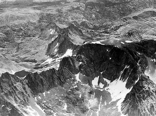
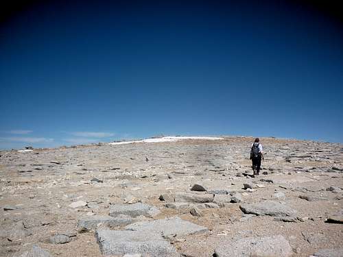
Table Mountain is a remote peak in Sequoia National Park, well recognized by its flat profile among the other peaks of the Great Western Divide. Table Mountain sits north of Midway Mountain and south of Thunder Mountain along the Divide and is one of the 248 peaks listed by the Sierra Peaks Section of the Sierra Club Angeles Chapter. The peak is somewhat unusual among its neighbors as the mountain’s vertical escarpments are capped by a large, relatively flat plateau. The first ascenders, Paul Shoup, Fred Shoup, Gilbert Hassell (Aug 25, 1908) estimated the plateau’s size to be seventy to eighty acres but a closer estimate puts it about half of that (35 acres). This is still roughly equivalent to 30+ football fields or 8 super aircraft carriers. The high point lies at the far northern end of the plateau overlooking the jagged north ridgeline to Thunder.
Table Mountain may have been indirectly named by Clarence King according to Francis P. Farquhar in his book Place Names of the High Sierra (1926), King stated “At one place the ridge between Mount Brewer and Kaweah Peak forms a level table.” Although the name appeared shortly afterward on maps, the peak briefly sported the name Hazen Mountain before officially receiving the designation from the USGS Board on Geographic Names in 1903. Norman Clyde is credited with FAs on three of the routes on the peak.
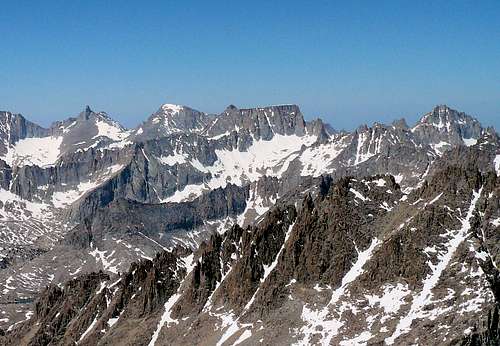
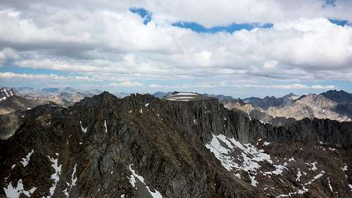 Table Mountain and surrounding area
Getting There
Due to its remote location, Table Mountain can be approached from a number of different directions depending on the itinerary. It’s debatable on what the best approach is but the closest trailhead approach is from Symmes Creek (Shepherd Pass) although Whitney Portal and Onion Valley are suitable (but much longer) entry points to the eastern side of the mountain. The easiest approach to the western side is via Marvin Pass but again, the approach distance is long enough that other options (Reflection Lake or Avalanche Pass) might be worth pursuing.
- The Shepherd Pass trail climbs from the desert floor up and over Shepherd Pass before dropping into the Tyndall drainage. After a short northward jog on the JMT (or cross-country), the Kern Basin cutoff trail heads west over a high plateau before dropping in the upper Kern basin. Cairns mark the start of the old Milestone Creek trail about a ¼ mile south of Kern River junction providing access to the east and southeast faces. Heading north from the junction provides access to the cirque below Thunder Col and the northeast face.
- The Marvin Pass trail starts from Horse Corral Meadows heading south over Marvin Pass before dropping down into Rowell Meadow. Head east on the Sugarloaf Trail until it terminates at a junction in Scaffold Meadows. From here, continue to head southeast on the Colby Pass trail in Cloud Canyon to a point shortly before you reach Whaleback. Head cross-country up Table Creek to the West Ridge, choosing either the cirque north or south depending on the desired route.
Routes
There are a number of interesting scrambling routes up Table Mountain and many other undocumented routes (from firsthand experience). RJ Secor’s admonishment to carry a rope maybe wise as it’s easy to get off-route.
 |
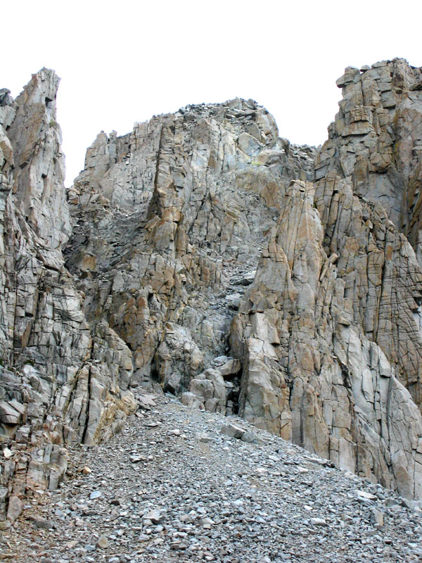
Southeast Face, Left Side: The standard ramp route as reported by Secor. Head up towards the gendarme but watch for wayward cairns that take you too high. The idea is to climb just above the right ascending ramp until you can traverse and then down climb on to it. The ramp itself is easy and the chock stone tunnel is a bit tight but doable. It is wise to mark your exit onto the plateau so you can find your way back. Easy Class 3. |
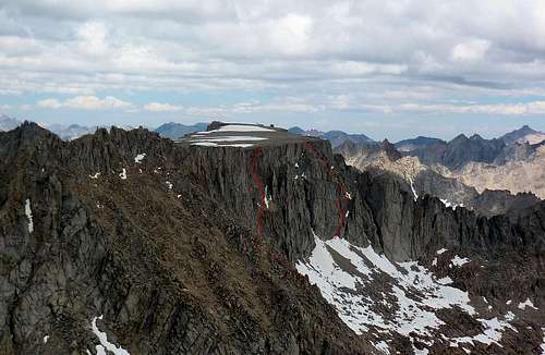 |
Southeast Face, Right Side: An undocumented route we used to descend – an old boot heal provided evidence that we couldn’t claim the route as an FA. A sandy gully with a stemming move leads to some ledge & crack climbing (bypassing the large chockstone on the left) before the final steep sandy slope heads up and to the left. A zoomed in view is seen here. Class 3+. |
 |
East Face: This route references the face approached from Milestone creek’s north fork. Reported in Hervey Voge’s 1956 A Climber’s Guide to the High Sierra as a Class 2 climb, Secor updates this rating to a loose climb with a Class 4 chockstone. Chances are high that there may be more than one route. |
 |
Northeast Couloir: This is the steep couloir between the plateau and the northeast ridge. Secor describes this as a 700’, 50 degree snow/ice climb. Class 4 |
 |
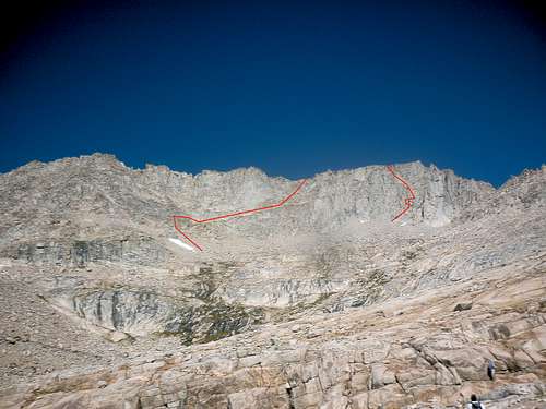
West Ridge, South Side: Steve Eckert describes this as a chute on the western face. His excellent description can be found here and describes taking the left of two chutes before climbing to the plateau proper. Class 3 |
 |
West Ridge, North Side: From the picture on the left, it’s hard to say which is the correct chute to the top of the west ridge(in bottom right corner of the picture) as described by Secor. This picture may have a better perspective. Scramble to the top of the plateau from the top of the ridge. Class 4. |
Red Tape , Camping, and Conditions
Everything you need to know about permits, regulations, and driving directions can be found on the Eastern Sierra - Logistical Center page. The parent SEKI page to this page is also filled with great information on the Park’s rules. While overnight hikes require a wilderness permit, day hikes can be done without red tape with the exception of entry from the Whitney Portal.
Climbing can be done in almost any season but May through October are the most popular times. In heavy snow years, the chutes and slopes may hold residual snow. This is also true for any of the routes over the Sierra Crest. Check for current weather.
External Links
Trip Reports:
Climber.org reports
Bob Burd’s day hike
Sierra Club reports
Pictures:
My pics & summary
Laura Molnar’s pics
Matthew Holliman’s day hike
Noondueler - Apr 21, 2009 12:25 am - Voted 10/10
Hi Russ!Just a note. I'm pretty sure Kaweah Peaks Ridge is not considered part of the Great Western Divide. By the way, got any more pics? I've never been back in there and would like to see more of this mountain.
bechtt - Oct 25, 2010 11:47 pm - Hasn't voted
Re: Hi Russ!Russ and I are sharing this page now and I've updated it based on my recent visit there. Tell me what you think.
Noondueler - Oct 26, 2010 11:26 am - Voted 10/10
Re: Hi Russ!Hi Bechtt. The page looks good to me, good job. My only suggestion would be to put another pic as the primary photo. The sunset shot is nice but it seems out of focus and kind of obscure. Later man!
bechtt - May 21, 2011 9:31 pm - Hasn't voted
Re: Hi Russ!Finally did it with a long shot from Silliman. Thanks for the suggestion. Tom
Noondueler - May 21, 2011 10:32 pm - Voted 10/10
Re: Hi Russ!Yeah, nice clear shot.