
-
 34201 Hits
-
 84.82% Score
-
 19 Votes
|
|
Mountain/Rock |
|---|---|
|
|
8.8925°S / 77.5793°W |
|
|
Hiking, Mountaineering |
|
|
19160 ft / 5840 m |
|
|
Overview
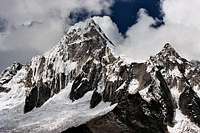
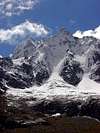
 Taulliraju
The Taulliraju is probably one of the mountains most photographed of the Cordillera Blanca (Andes-Perú) after the famous Alpamayo. Its popularity is due to its great beauty and to the great quantity of persons that they walk the Santa Cruz's trekking. The known step-crossing of Punta Unión (4750) of the stage 2 of the trekking it passes between Taullipampa and Huari under the incredible presence of this great mountain.
It is necessary to warn that normal routes do not exist to this mountain and there are neither companies nor guides who dare to offer it for its great difficulty. An expedition to this mountain is reserved to mountaineers very professional and experienced and needs a great infrastructure of material of ice climbing.
 Taulliraju
When the great french climber Lionel Terray conquered the summit for the first time in 1956 he said "in the history of the mountain-climbing it has never been so laborious the conquest of a peak" (in his book "Conquistadors of the useless: from the Alps to Annapurna"). Lionel Terray was the first climber of important summits like Makalu, Fitz Roy, Chacraraju or Jannu (he's one of the most important rock-climbers of the history). More than 20 years happened before someone was returning to reach the top (a Japanese expedition)
 Taulliraju
The 2 "easier" routes used for its conquest are indicated as MD (very difficult):
- north face from the col Taulliraju-Rinrijirca: L Terray and his team.
- ridge S-SE.
The rest of routes are ED (extremely difficult).
All the routes include a great number of long step-crossing in ice of at least 60º and some of 70-85º. Generally a part of the material (ropes, stakes,...) must remain in the mountain.
The name: Taulli: little blue flower of the zone. Raju: Nevado (mountain of snow).
Note: Of course this page is really to show this impressive mountain and to write the routes of the most popular trek of Cordillera Blanca, the trek of santa Cruz, but the climb is impossible for almost all the normal mountaineers.
 |
 |
 |
 |
 |
 |
Getting There
The same of Santa Cruz Trek up to Taullipampa. For approach to Huaraz you can see the page of Cordillerra Blanca-Range.Trekking of Quebrada de Santa Cruz
The Santa Cruz Trek is the most classic trek of Cordillera Blanca but the duration can to change between 4 and 7 days according to the goals wished in the Cordillera Blanca. The word "quebrada" mean generally canyon.Day 1 (approach):
Approach to Cashapampa from Huaraz
Generally you can to take a collective or contract the trek with some agence of trekkings for this (with cook, guide, muleteers and donkeys). The road to Caraz is asfalt but after this village the road is a track to Cashapampa (2900m). In Cashapampa you can to contract muleteers (arrieros) with donkeys to take your baggage.
You must to camp in the places signaled for the National Park of Huascaran.
Day 1 (walk):
Cashapampa-Llamacorral (3750m)
The beginning is easy with a nice path near of the river to reach the upper plain of Llamacorral. You can to see the first Nevado (the Taulliraju of course) in the middle of the Quebrada. 4h.
 Day 2:
Llamacorral-Taullipampa (4350m)
The stage most comfortable in slope (great pampa) enjoying of the views of new Nevados (Caraz, Agujas, Abasraju, Curicashajana, Rinrijirca) and the lakes (Itchicocha and Jatuncocha). In the crossroads of Quisuar generally it’s a good idea to climb a short trail near the basecamp of Alpamayo to enjoy of the views of Quitaraju and Alpamayo (some people make this the next day and they go to the basecamp and return to Taullipampa). 5-6h
Posibilitys for extra day in Taullipampa (generally it's a good idea to sleep another day at 4350 meters):
-trek to basecamp of Alpamayo and return (4300m).
-climb of the Cerro Sentilo (5100m).
 Day 3:
Taullipampa-Huaripampa (3300m)
The route go across the Punta Unión Pass. Punta Unión (4750m) is the highest point of SantaCruz's trekking and a good place to achieve the acclimatization to the height. After this point the route descent to the Quebrada Huaripampa across the basecamp to entry to Quebrada Paria. There exist several different places to encamp (quenuapampa,... ) but it must be avoided the localized in the entry of Q.Paria placed in the middle of a forest by the great quantity of insects that it has.
Day 4:
Huaripampa-Vaqueria
We'll leave the National Park (checkpoint, payement 2soles in 2004) and we'll go across the first little villages (the little Huaripampa under the nice Chacraraju) and Colcabamba. Following to the signal to the village of Vaqueria to get the car and we'll go to Huaraz or Llanganuco-Cebollapampa if you go to the Pisco’s area.
Extras days:
-Q.Itchic Ulta: avalanche camp (4500m), Punta Yanayaku Pass (4850m). 2 days. Great views of avalanches and Nevados Contrahierbas, Chopicalqui, Ulta and Huascaran.
-Portachuelo of Llanganuco (4767m): trek (2 days) or car. Views of Nevados Huascaran,Chopicalqui, Pisco and Huandoys. It's the option for the people what want to climb the Nevado Pisco the next days.
 |  |  |  |  |
Red Tape
Fees of 20$ to entry in National Park of Huascaran (2004).For more information you can to consult the pages of Urus Este and Cordillerra Blanca-Range.
 |  |  |
When To Climb
July, august and september (dry winter in Peru).Camping
Camping allowed in the signaled areas (Llamacorral, Taullipampa,...). Not huts, not fees.If you wish to contact with some trekking's companies you can see my page of Urus Este
 |  |  |
Mountain Conditions
Generally the months of july, august or september are dry (not rain) with a good temperature in the day (t-shirt, shorts,...) but it's very cold in the late afternoon and the night (really it's winter time in Perú but it's a tropical zone). You must to take the sleeping bag for winter and cold clothing (polar jacket, gloves,...).External Links
- nuestramontaña.com
Complete description of Trekking of Santa Cruz (spanish)
- Photoseek-Perú
Great pictures about the trekking of Santa Cruz, a little map and some of information (english).
- Mountaineering in the Andes
by Jill Neate Peru. RGS-IBG Expedition Advisory Centre, 2nd edition, May 1994. Peak list of Cordillera Blanca and a lot of information