

-
 52581 Hits
-
 93.1% Score
-
 41 Votes
|
|
Mountain/Rock |
|---|---|
|
|
9.41111°S / 77.43418°W |
|
|
Mountaineering |
|
|
Winter |
|
|
20217 ft / 6162 m |
|
|
Overview
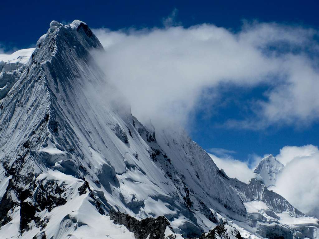
Ranrapalca 6162 m
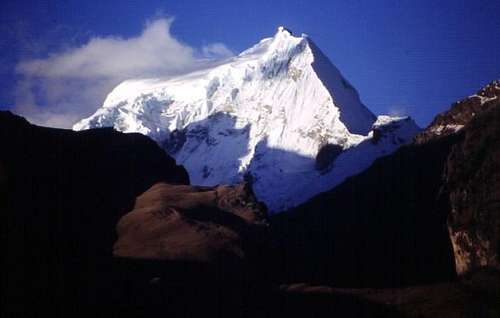
Ranrapalca 6162 m is one of the most breathtaking mountains of the Cordillera Blanca in Perù, Ancash department. It is easily seen from Huaraz and overwhelming to everybody climbing nearby Ishinca (5.530m).
Its name comes from the Quechua words ranra=stone and pallqa=divided and it refers to the two distinct summit peaks that can be seen from some angles. It is one of the most evocative mountains that can be seen from Huaraz and one of the most fascinating in the entire Cordillera Blanca. To be precise, the mountain is located between the Cojup and Ishinca canyons and shows a long ridge starting near Vallunaraju and ending near Palcaraju. It rises between the steep and vertical Oshapalca and the gentle Ishinca. Ranrapalca is often climbed by it North-East face, its normal and easiest route. Its North Face is a superb climb.
History
The first ascent of Ranapalca was carried out by the Germans Walter Brecht, Siegfried Rohrer, Karl Schmid and Hans Schweizer in June 1939 via the NE ridge.
Getting There, HUARAZ
Getting to Lima
Fly to Lima. There are different flights getting to the Aeropuerto Internacional "Jorge Chavez" in Lima, both from Europe and North America, obviously many more from South America. The airport is situated in Callao (about 12 km West to downtown). You can find a bed in various hostels in Lima before to start to Huaraz. Another possiblity is taking the bus directly to Huaraz.
Getting to Huaraz
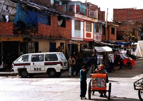
Huaraz, the capital of the Ancash region and Cordillera Blanca, is a lively and bustling town located about 3000 meters above sea level, which offers several opportunities for accommodation and food, and also easily the possibility to arrange on-site transportation and trekking for people who haven't previously booked any service. There is an airstrip in Anta (20km from Huaraz), but the flights from Lima are not regular, so bus transportation is the only way to go there by means of a 7-9 hour ride. At moment, the best way to get to Huaraz is a 6-8 hours trip by bus or private minibus (if you're travelling with your own organized expedition). Currently, comfortable coaches provide a good transportation from Lima to Huaraz. There are six different bus companies and most of them will charge for extraweight. The best ones are Cruz del Sur, Movil Tours Ormeño and Ancash Express. Three of them are listed below:
Cruz del Sur: Phone 424-1005. Departure at 10 a.m. and 10:15 p.m. 7 hour ride for $20-30 and includes onboard lunch
Movil Tours, Paseo de la república 656. Phone 332 0004 or 0024. Departure at 11:00 a.m. 7h hour ride for $15-30 and includes onboard lunch
Ormeño: Av. Carlos Zavala 177. Phone 427 5679. Departure at 7:00 a.m. and 12:00 a.m. 9h hour ride for $10-20 and stops for lunch.
Once in Huaraz you can find dozens of hostels. In High Season it is recomended to book in advance.
Getting There, BASE CAMP IN QUEBRADA ISHINCA
Getting to Collon
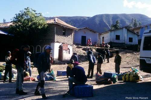
The starting point of the trail to Quebrada Ishinca is situated in Huillac, 2km past the little "pueblo" of Collon, located NE to Huaraz. The cheapest way to get to base camp is getting public transportation to the little village of Paltay before Taricá, along the Calleyon de Huaylash main road. From there hike or hitch up to the village of Collon or find a ride up the dirth road to Collon and Huillac. In Huaraz you can also arrange with a small truck owner to bring you straigth to Collon. This is surely the quickest way and the most convenient option if you are in your own expedition or if you share the transport with other passengers. The best choice is to arrange previously for "burros", anyhow if you haven't provide for in Huaraz, in Collon you can hire arrieros (muleteers) with the traditional burros (donkeys) to help you to carry your gear to Quebrada Ishinca base camp (3-4 hours from Collon, about 15 km), but make sure to be in Collon early in the morning. To improve your fitness it's as well possible to hike to the BC without burros, but it surely requires an additional effort. From Collon drive about 2 km past the village to the small group of houses in Huillac, where you will find a small PNH (Parque Nacional Huascaran) office. Here you will be asked to sign the guest book and asked a little money in order to keep the trail to Base Camp in good shape. Also you will be offered the services of "Burros" and "Arrieros" (donkeys and muleteer) and it is very likely that you will accept it.
Another possible trailhead is Pashpa, some 30 min. above Collon, reachable by minibus or by truck. Especially when you return from Ishinca this trail is very recommended as it offers great views of Huascaran and the C.B.
The dirty road getting to Huillac continues above and past Huillac for about one kilometer. The trail to Quebrada Ishinca starts on a bend near a bridge.This attractive path, always heading to the East direction and leaving the stream on the right, is easy to follow. The trail crosses Cordillera Blanca widest forest of "quenuales" trees; along the way you encounter three spectacular rocky monoliths. After about 4 hours (3-5h depending on your acclimatization) of walking you exit to a vast plain located at the head of Quebrada Ishinca, open towards the glaciers of Tocllaraju 6034 and Palcaraju 6244 m. A deviation to the right, crossing the river on a wooden bridge, leads near some huge granite boulders; here Quebrada Ishinca offers a wide area to put up your Base Camp at about 4400m. Quebrada Ishinca is a nice place to put up your BC and a great place to acclimatize climbing lower peaks like Urus (5.420m), Ishinca (5.530m), and even the beautiful Tocllaraju (6.032m).
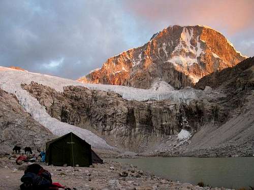
Getting There, ADVANCE BASE CAMP & CAMP 1
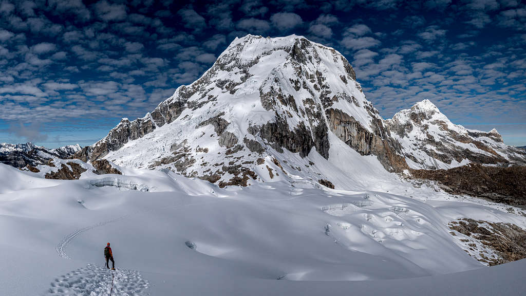
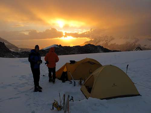
If your acclimatization is good I suggest that you camp first day higher up from Quebrada Ishinca, by the new wooden cabin (4.800) a bit higher than Ishinca Lake, on the way to the Ishinca SW Ridge Route. 1-2h from Base Camp. From there Ranrapalca North Face is huge and breathtaking; to the left of it is Ishinca and right in between them, the col to where to go if the NE ridge or the NE slopes are our routes, it will make a good spot to set our Camp 1in that case. If the North Face is our aim, we will set Camp 1 by the glacier right by the North Face but not too close to prevent rock falling.
In the second day we will take the route to the Ishinca Glacier, using a zigzag trail to the col (mountain pass) located between the Ranrapalca and Ishinca glaciers
Routes
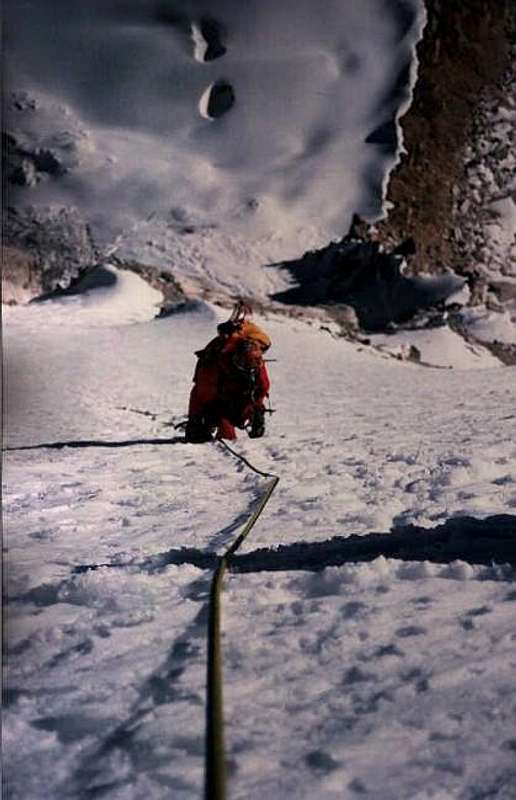
"First time I attempted Ranrapalca was in the summer of 99 via the NE Spur; half way on the route my two basque friends and I had to traverse to the left to catch up with the NE slopes because the snow-ice conditions at 10:00 am where as bad as waist deep corky snow while climbing the sharp´s edge ridge with 600m fall to one side and 150m fall to the other. Not to improve, because the rockfall from the rocky band way above the NE slopes was continuously testing our nerves to the point to make us bail out. The next summer I met up with mexican Emiliano Fernandez and climbed the North Face and descended via the NE slopes".
- NE Slopes, D-
From the Ranrapalca-Ishinca col, that can also be gained from Q. Cojup. Climb the easy slopes to the left of the ridge then two sections through seracs, 60º. And crossing the bergschrund and climbing the ice-wall of a small serac is the crux, specially if we have to find the point to go through it in the middle of the night with the only help of the light of our headlamps. On an easier terrain you could join the NE ridge and climb it to the summit plateu or climbing the slopes straight forward to the summit plateu. Traverse 500m South to the sharped summit
- NE Ridge, D It's the route of the first summiters and the most frequently climbed during the season. From the Ranrapalca-Ishinca col climb steep mixed NE ridge to snow summit platform. Traverse 500m South to the sharped summit
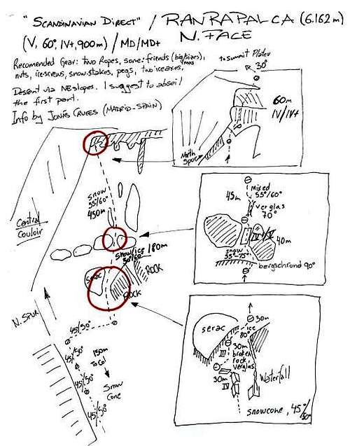
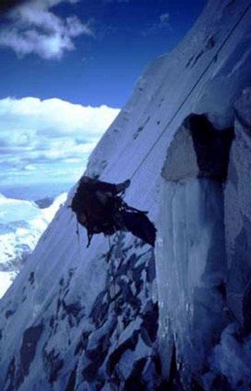
- N Face, Scandinavian Direct 1996, MD/MD+ (V,60º [90º],VI+[V], 900m) The route starts to the right of the central couloir of the North Face. We would have to cross over the rock band on our right, and ascend the snow cone for about 150m. Traverse right under the serac over rock, mixed, ice an snow to head again up in order to climb between the 3rd. and the 4rth. group of rocks in the middle of the face, before arriving to that point we will have to go across the bergschround. From the rock group head up a little left just to leave another rock group right by our left. Keeping on that line we would be getting closer to the N spur to meet with it right at the very top of the face. A short rock section and a gentle snow slope will leave us in the summit plateu. Looking south opposite to us the knife edged summit crowning the summit plateu
Descent: via NE slopes, I suggest to abseil the first part. Some years it is hard to find the way through the bergschround of NE slopes, make sure to be there by daylight.
Recomended gear: two ropes, some: friends (big/med sizes), nuts, ice-screws,snow-stakes,pegs and two iceaxes.

NEW ROUTES
- Ranrapalca South face, about 6km wide, with rock, ice, and snow rising for 750-850m, had been climbed by the Peruvian mountaineers and guides (AGMP-UIAGM) Eloy Salazar Obregón, Octavio Salazar Obregón, and Eric Albino (aspirant guide) starting in the Cojup Valley.
More info: Americanalpineclub. Nevado-Ranrapalca-La-Paliza-del-Ranrapalca
- Ranrapalca North West Face climbed by the Pou and Micher Quito brothers
In August 2023 the still unclimbed North West Face of Ranrapalca was climbed in alpine style by Iker Pou, Eneko Pou and Micher Quito with their mixed route 'Ya Pe' Cholo' (6b/80°/1200m). After establishing new routes on Nevado Huamashraju Este in 2021 and on Urus Oeste and Pumahuacanca in 2022, Basque climbers Eneko and Iker Pou have once again teamed up with Peruvian Micher Quito to complete another new route in the Peruvian Cordillera Blanca. In August the three climbed the previously unclimbed northwest face of Nevado Ranrapalca
More info: Planetmountain - Ranrapalca NW face
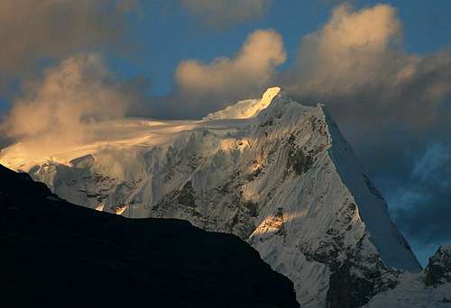
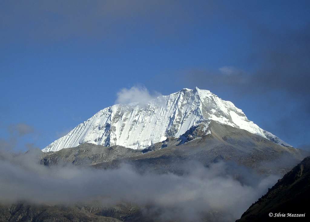
Ranrapalca different perspectives

|

|

|

|
When to climb
Best to climb the mountain in June-July, some years it can be climbed as late as in August.

Red Tape
There are no proper fees to climb the mountain, although you will be asked for a little money the day you sign up in Collon in order to keep the trail to BC in good shape. Ranrapalca and the entire Cordillera Blanca are located within Parque Nacional Huascaràn, one of most spectacular high mountain area in Perù, established in 1975 and acknowledged as an Unesco World Natural Heritage in 1985. Unesco Link here: Unesco info The Huascaràn National Park is administered by the Instituto Nacional de Recursos Naturales (INRENA). An entrance fee is due (US$25.00 per person). Since 2011, officially nobody is allowed to climb without a Mountain Guide, except for the persons who are members of a Mountaineering Association. In this case, the permit can be obtained at the National Park Office in Huaraz, showing the Alpine Club card.
Always be respectful of this fragile landscape. Carry-out everything you bring in and any litter that you carry-in or that you find on the routes and help to conserve the beautiful landscape! Take care of nature as usual in the natural sites and particularly within the boundaries of all the natural parks.
Mountain condition
The Casa de Guias situated near the Plaza de Armas in Huaraz is THE spot where to gather information about recent snow and weather conditions. You will also find a posting board to place adds to find climbing partners and/or equipment for rent or sale. The typical climbing season is May through mid September during the Andean dry season. Even though technically it is winter during this time, the Cordillera Blanca is so close to the Equator that the days are all more or less 12 hours each and do not change in length. The wet season brings considerably more moisture to both the mountains and the city of Huaraz.
Suggestions
- Not far from Huaraz there are some sport climbing crags and boulders, look for: Recuay, Huanchac, Masuan, Monterrey y Laguna de Llanganuco.
- In Huaraz there are also some climbing stores that are not cheap.
- The notice board of Casa de Guias in Huaraz has a similar function to the one in Yosemite´s Camp 4. Also 'Casa de Guias' is the place to get information related to mountain and weather conditions.
- I suggest to use public transportation or 'Colectivos'.
- There is a very much trusted laundry service named 'B & B' located at 674, Av. José de la Mar.
- There are Internet facilities all over Huaraz.
- Best if you treat all water before you drink it.
Meteo
Books & Climbing Magazines
"Escaladas en los Andes" (Guya de la Cordillera Blanca) by Juan José Tomé Ñacle, Ed. Desnivel 1999
"La Cordillera Blanca de los Andes" by Antonio Gómez Bohórquez and Juan José Tomé Ñacle, Ed. Desnivel April 1998 Juanjo Tome´s article about La Cordillera Blanca published in the climbing magazine:
"Desnivel" 144 may 1998 Rock&Ice #71 & #88, there is information relating La Cordillera Blanca
“Climbs of the Cordillera Blanca of Peru” by David M. Sharman, Ed. Whizzo Climbs 1995
"The High Andes" (Guya por climbers) by John Biggar, Ed. Andes 1996
“Yuraq Janka” de John F. Ricker, Ed. ¿? 1977


Information
All info gathered by: Jonás Cruces Mountain Guide & Rock + Ice Climbing Instructor
This is his website: www.todovertical.com