
|
|
Mountain/Rock |
|---|---|
|
|
9.40808°S / 77.36891°W |
|
|
Hiking, Mountaineering |
|
|
Spring, Winter |
|
|
17766 ft / 5415 m |
|
|
Overview
The best views often are not those from the highest summits, but from slightly lower ones nearby. Being high already gives a great overview, but having bigger peaks towering over you adds something special. If you want to have that experience in the Cordillera Blanca, but want to avoid the more crowded peaks, Nevado Jatunmontepuncu is one of the best places to go. There is a small glacier on the summit, but in normal conditions, it's an easy climb.A long ridge stretches out to the southwest from the massive Nevado Pucaranra (6156m). The ridge separates two big valleys: Quebrada Cojup on the northwest, and Quebrada Quilcayhuanca on the southeast. After dropping steeply, almost 1000m in 2.5km, the big glaciated ridge reaches a saddle at just over 5200m, with steep slopes on either side.

Looking down the long ridge
Still less than 3km from Pucaranra, Jatunmontepuncu, also known as Huapi, is the first significant summit on the ridge. From the saddle with Pucaranra, a steep rocky ridge rises to the northern summit, with a pointy false summit in between. In the other direction, the southwestern ridge continues relatively easy for a few hundred meters, depending on the state of the bergschrund near the summit. Further away, it gets a bit more difficult again. At that point, the ridge can be gained either from either the Cojup valley to the west, or the Quilcayhuanca valley to the south.
About 1.5 km southwest of Jatunmontepuncu, at around 5100m, lies Huapi pass. Although the trail on the Cojup side is a bit steep, this is still a hiking route, which does not require special gear.
From Jatunmontepuncu, the ridge continues for another 10km, culminating in the steep southwest face of Nevado Churup (5495m), with the popular lake at its base.
While Churup is clearly visible from Huaraz, most of the ridge behind it is not. Jatunmontepuncu and Pucaranra are both hidden behind Cerro Rima Rima, a minor summit on the southwest ridge of Ranrapalca.
From the summit, next to Pucaranra, the best views are of Nevado Palcaraju (6274m), but in addition, you can see Nevado Ranrapalca (6162m), Nevado Huantsán (6369m) and Nevado Copa (6188m), and, although mostly blocked by Pucaranra, Nevado Chinchey (6309m). And then there are Nevado Ishinca (5530m), Nevado Andavite (5446m), Nevado Tullparaju (5787m), Nevado Maparaju (5326m), Nevado Urus (5495m) and Nevado San Juan (5843m), to name just a few more.
 Huantsán sunrise | 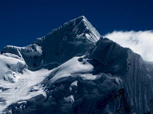 Palcaraju | 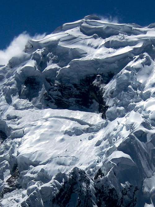 Pucaranra | 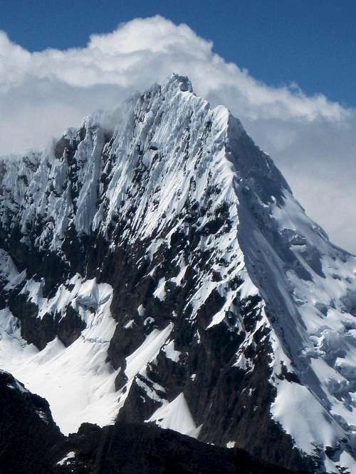 Tullparaju | 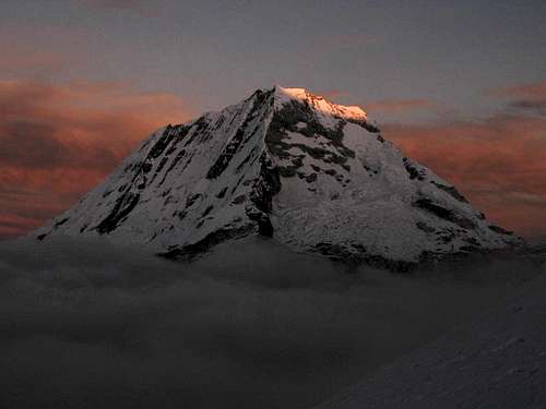 Ranrapalca sunrise |
First Ascent
A. Szepessy, M. Sony, 5 July 1948, from Quebrada Quilcayhuanca and the SW ridge (see [4]).
What's in a Name?
To my surprise, when I asked around at various operators and in Casa de Guias in Huaraz, I found that the mountain wasn't well known at all. Most people I talked to had not even heard about it, and those that did, mostly by the name Huapi. That means that the mountain isn't climbed often. Nevertheless, I came across an old trail, so I wasn't the first one to try it in the 2011 season. However, the trail stopped at the bergschrund shortly before the summit. See the Routes section for more about that.
The name on the AV map is Jatunmontepuncu. Other maps say Huapi. Different books ([3], [4]) give different names too. In fact, [4] writes it as Jatunmontepunku.
| A very small quechua dictionary | |
|---|---|
| Cocha | Lake |
| Jatun, hatun | Big |
| Puncu, punku | Door, doorway, portal, entrance |
| Raju | Mountain |
| A very small spanish dictionary | |
|---|---|
| Cerro | Hill, mountain |
| Monte | Mountain |
| Nevado | Snow peak, snow mountain |
| Quebrada | Valley, ravine |
A mixture of Quechua and Spanish, Jatunmontepuncu translates to something like "Big Mountain Door".

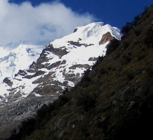
Jatunmontepuncu from the southeast
Jatunmontepuncu is pronounced as [ˈχaːtuːnmɔntəˈpuːnkuː], Huapi as [ˈwɒpiː] (for an explanation, see the International Phonetic Alphabet).
 |
Getting There
Lima international airport has direct connections to a few major cities in Europe and North America, and many more in South America.Huaraz is the capital of the Ancash region, and by far the largest city. From Lima, you may be able to fly to Huaraz airport, which lies north of Huaraz itself. Occasionally, there are commercial flights to and from Lima, but usually the service doesn't last. In 2011, I saw an ad that there would be regular flights again, starting in a few days, but I think it didn't take off. However, when Huaraz keeps growing, at some point I expect there to be a regular service.
Most travelers come to Huaraz using one of the long distance bus services. Thanks to improving roads, it's about 7 hours from Lima. And although, officially, there is a luggage weight limit on the buses, the surcharge is low, and the weight is not checked very rigorously anyway.
Two good bus companies are Cruz del Sur and Movil Tours.
From Huaraz to either of the two trailheads by taxi takes about one hour. Collectivos go as far as the village of Llupa (-9.512,-77.473) (3500m), from where it takes an hour and a half to walk to both trailheads.
Routes
 Map of the area around Jatunmontepuncu
Steep walls line Quebrada Cojup
Western slopes, SW ridge (F/PD)
The normal route (F/PD) is from Quebrada Cojup. Two dirt roads lead to the trailhead at the entrance to the valley (-9.480,-77.449) (3850m), one coming from Llupa, the other from El Pinar, but ultimately both from Huaraz. Take a taxi to the entrance, or, much cheaper, a collectivo as far as Llupa, from where it's a 1.5 h walk to the trailhead. Either follow the road, or take one of the many footpaths. As the crow flies, the trailhead is 4 km NE of Llupa.
Jatunmontepuncu from Quebrada Cojup
There is a well worn footpath in Quebrada Cojup. Initially, the river is on your left, but after two hours, a bridge takes you to the other side. As you walk, the views of Pucaranra and, later, Palcaraju get better all the time. If you know where to look, you can see Jatunmontepuncu coming into view from far away, high on the ridge on the right.
Some four hours from the trailhead, deep in the valley, is an Ingemmet cabin. It's just under 2 km due west of Jatunmontepuncu. From there, a trail ascends the slopes towards Huapi pass to the southwest. You can camp at Lake Palcacocha, 20 minutes beyond the cabin, or anywhere in the valley for that matter.
Another trail to Huapi pass begins a little bit lower in the valley, west of the pass. Where the valley floor gets narrower, but with a plateau on the other side, cross the river and head up the plateau. It is a big flat space, and I saw people setting up camp there, but didn't see a water source. Perhaps there was one, because if there wasn't, why did they not camp closer to the river? At the north side of the camp site on the plateau, a trail heads up the slopes, leading to the pass.
Higher up, the vegetation gives way to talus fields and the trail fades. Cairns mark the route to the pass now, but there are not all that many. I can imagine that it would be possible to loose the way. In good visibility, that wouldn't be a problem: The terrain is not that steep, so if you want to go over the pass, just aim for the lowest point on the ridge, well away from the glacier.
To climb Jatunmontepuncu, the cairns are no help anyway. Shortly after reaching the talus, you have to find your own way to the SW ridge, much closer to the summit than to the pass. Route finding is actually quite simple: aim for what appears to be the summit - see the photo - and see to it that you get on the ridge shortly before. It's actually a false one, the true summit lies 15 minutes behind it.
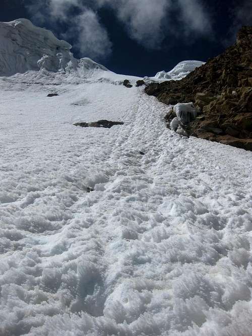 Below the steep pitch | 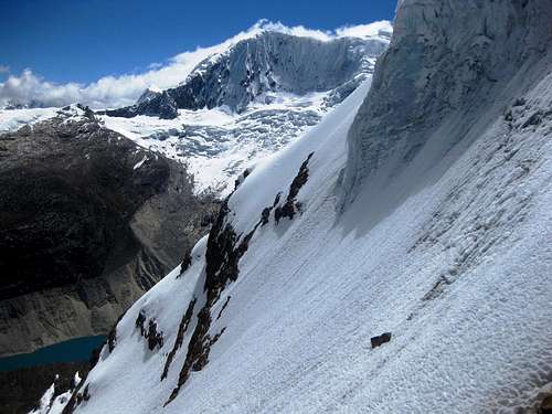 On the steep pitch | 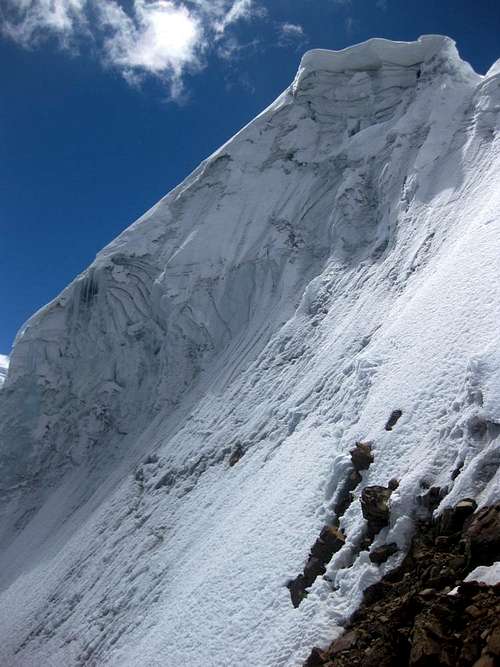 High on the steep pitch | 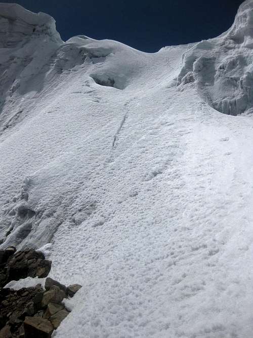 High on the steep pitch |
The steepest section is one pitch of up to 50°, on the glacier just before gaining the ridge. Once you're on the ridge itself, it's a few more minutes to the false summit, which, in 2011, was blocked by a big bergschrund with an ice wall on the other side. An old trail lead to the right hand side of the schrund, but no further. There clearly was no way across. There was no trail to the left. I didn't understand why, so I had a look myself. Far to the left, the bergschrund was almost gone, and the wall was just above my head. I didn't dare to climb it directly, because I feared it might be a cornice and it could break when I tried climbing it, sending me down the unknown other side. I didn't give up yet though. I decided to chop a bit off the top, so I could actually see the other side, and was very happy to discover an easy slope, no more than 30° and quickly leveling off towards the false summit - mind you, a bit further left it got really steep.
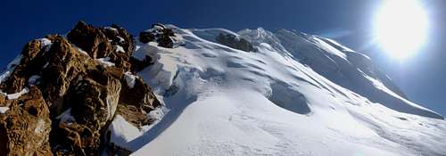
From the false summit, it's a short hop on a flat glacier to the bottom of the final pitch: 20m up and about 40° steep. The annotated panorama in the Overview section is photographed here.
The summit itself is rather small, with a dizzying drop on the other side. I enjoyed the moment, with my legs dangling down.
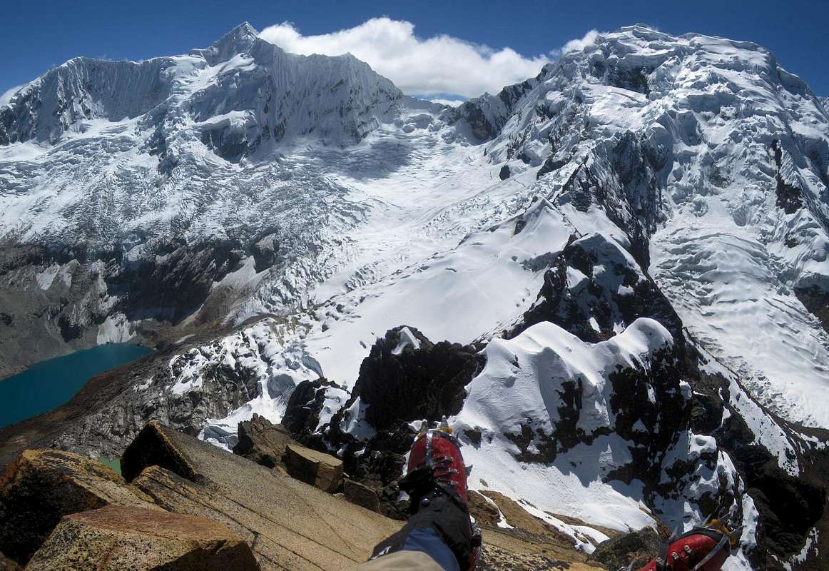 Summit view to Palcaraju and Pucaranra
Early on in Quebrada Quilcayhuanca
Southern slopes, SW ridge (F/PD)
An alternative route comes from Quebrada Quilcayhuanca. This is the route of the first ascent. The trailhead (-9.498,-77.416) (3850m) can also be reached by taxi, or by walking 1.5 h from Llupa. You'll pass the Laguna Churup trailhead (-9.506,-77.442) (3850m), the starting point of a popular day hike. You could ask the local operators in Huaraz whether they plan to bring a group to the Churup trailhead and get a ride that way. Should be cheaper than a private taxi.
From the Quilcayhuanca trailhead it's about four hours to the junction with Quebrada Cayesh. The Quilcayhuanca valley makes a gentle turn to the left there, and the deeper you go into the valley, the better the views of Pucaranra and Tullparaju. After a while, Jatunmontepuncu appears into view, but from this side, it's not impressive at all. There are plenty of good camp sites by the many lakes at the end of the valley.
The south face from the SW

At the bergschrund
From Laguna Cuchilla, deep in the Quilcayhuanca valley, the route starts by going west, towards Huapi pass. You can follow the trail and cairns for a while, but by the time you're getting higher, at around 4800m or so, aim for where the glacier meets the SW ridge. In fact, I camped on the glacier just above that point, at (-9.410,-77.372), about 5250m high. It was a bit of a shallow depression in the glacier, sheltered by some rocks on the ridge.
Depending on the condition of the ridge, you may not want to follow it directly from there, but drop below it on the southeastern side. That's what I did. I headed east again, traversing the southern slopes and away from the ridge for half an hour or so, to get a good look at it, then climbed towards the ridge again. The slope that I selected to climb turned out to have deep powder higher up, up to 50°, and it was very tiresome. Perhaps I could have gone back up to the ridge earlier than I did, but I thought that following the ridge might not be easy.
I saw a few crevasses on the glacier, east and below where I was climbing. I also saw a small old avalanche debris field and a few small seracs high on the ridge. I stayed left of those.
Trekking options
Quilcayhuanca trailhead map
Another interesting possibility is Quebrada Quilcayhuanca - Huapi - Cojup - Ishinca - Quebrada Ishinca. Ishinca requires glacier equipment, even without climbing to the summit. Plan for at least four days.
Accommodation and Camping
There are lots of accommodation options in Huaraz, in all price ranges. Between climbs, I stayed at Edwards Inn. It's a relatively cheap place, offering rooms with a private or shared shower and bathroom. Mostly with hot water. Edward himself is a qualified mountain guide. Although he doesn't guide anymore, he is still very knowledgeable and enormously helpful - he helped me with this page as well.When camping in the Cordillera Blanca, if there is vegetation around, you can be sure there are cows too, so you have to treat your water. I saw cows high on the southern slopes of Jatunmontepuncu, and more in the Quebradas Cojup, Quilcayhuanca and Cayesh. Edward told me not to use the water from the main river in Quebrada Cayesh, and because that drains into Quilcayhuanca, I didn't take water from that river either. Instead, I took water from the smaller contributaries running down the slopes, and melted snow from the glacier on Jatunmontepuncu.
A few days later I talked to a few other visitors to the Quilcayhuanca and Cayesh valleys who had not been warned about the water. They didn't get sick, but said it didn't taste very good. Perhaps the pollution is of a mineral nature.
The Palcacocha Disaster
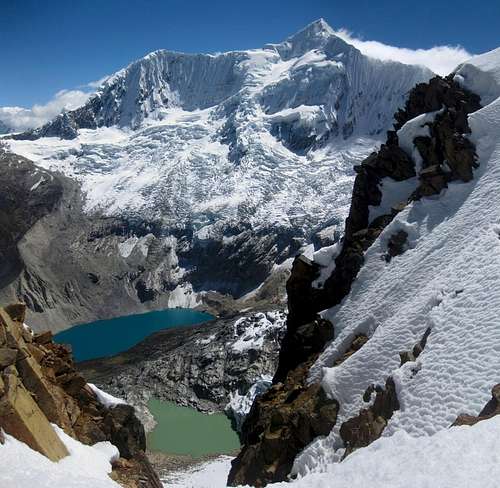
Palcaraju towering over Laguna Palcacocha - in 2011
These days, the lakes in the Cordillera Blanca are constantly monitored, and some have dams to control the water level. As a result, the risk of a flood is much lower now, and if something should happen, there is some time to warn the endangered towns. As for Palcacocha, the glacier has receded a lot, and with that, the danger has decreased substantially.
Red Tape
The Cordillera Blanca is a national park, named after its highest mountain: Parque Nacional Huascarán. If you want to visit, you need a ticket. It's 65 Soles, in 2011. On the official ticket it says "Valid for 7 days", but there seems to be some confusion about that. Edward told me that it was not correct, even though the ticket says so, and that it was valid for a month. After that, I only bought a new ticket when my old one was a month old.
Oblivious cows grazing in front of Pucaranra
More importantly, if you want to climb any mountain in the Cordillera Blanca, you must either go with a guide, or get written permission from a park official. I found the people at the National Park office in Huaraz always very friendly and helpful in obtaining one.
The permit is free, but to get it, you have to prove that you have enough experience. The easiest way to do that is to show your alpine club membership card. The unspoken assumption is that mere membership equals experience. A scary thought, when you think about it, but at least this will weed out most of the ill-prepared ones. The formalities also require you to provide the details of your insurance policy. However, if you end up in trouble, don't count on a rescue operation.
Somewhere along the road between Llupa and Pitec, a park ranger checked my park pass. However, when I also showed my climbing permit, he had no clue what it was for.
When to Climb

Clouds swirling around Tullparaju
Although Peru lies on the southern hemisphere, it's not far from the equator and temperature differences over the seasons are relatively small. However, as the seasonal weather patterns see significantly less precipitation by late fall through early spring, that's the best time of year to go. In winter you can have long periods without any precipitation, and days that typically start with clear skies, followed by buildup of clouds covering the high summits, then clearing again later on. Jatunmontepuncu is not quite as high, so it may well still be clear while the surrounding summits are in the clouds.
The best time to climb is from June to August. I encountered deep unconsolidated powder on a steep southern slope in June. A few weeks later, it may well have been more solid.
Maps, Books and References
[1] The best map is the Alpenvereinskarte 0/3b Cordillera Blanca Süd (Perú), 1:100000.[2] Casa de Guias in Huaraz can help you finding a guide, porters, et cetera, but they couldn't tell me much about the mountain. Mules cannot make it across Huapi pass. Alternatively, there are many outfitters in town, happy to provide anything from transport to the trailhead to an organized climb.
[3] John Biggar: The Andes - A guide for climbers, 3rd edition, 2005. ISBN 0953608727.
[4] John F. Ricker: Yuraq Janka: Guide to the Peruvian Andes - Cordilleras Blanca & Rosko, 1977. ISBN 9780930410056.
[5] RECENT GLACIER FLUCTUATIONS IN THE TROPICAL CORDILLERA BLANCA AND ASPECTS OF THE CLIMATE FORCING by Christian Georges. This thesis gives a lot of interesting information about the glaciers in the Cordillera Blanca, and Chapter 3 deals with the Palcacocha situation.
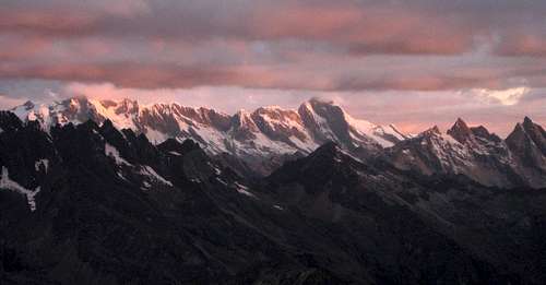
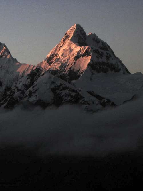
Twilight over the southern Cordillera Blanca