
|
|
Mountain/Rock |
|---|---|
|
|
38.33700°N / 105.378°W |
|
|
Hiking, Mountaineering |
|
|
Spring, Summer, Fall, Winter |
|
|
13334 ft / 4064 m |
|
|
Page is best viewed at monitor resolution of 1024x768
![Venable Peak]()
![]()
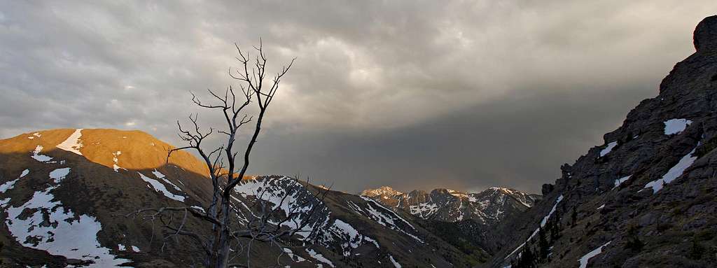
Venable Peak surveys a spring storm over Kit Carson
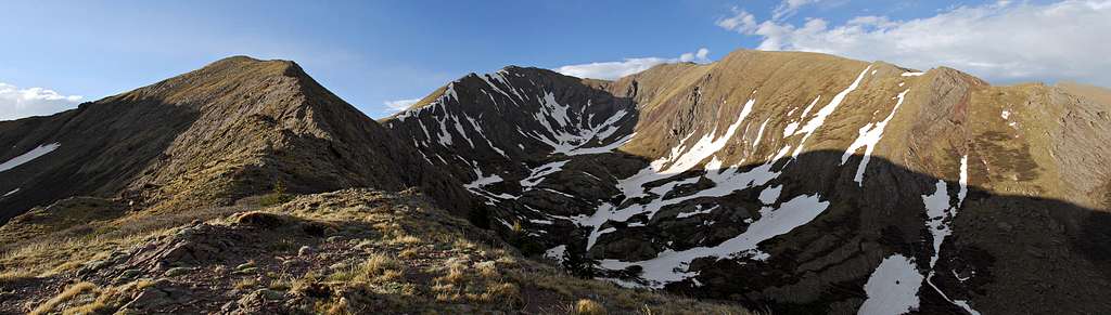
So why does Venable Peak (13,334-ft) deserve its own page on Summitpost? Because Venable’s location is primo, it’s that simple. Venable’s summit marks the spot where the Sangre Range goes from rugged beauty of the unforgettable Crestones, to the more fluid and sweeping summits of the Rito Alto, Wild Cherry and Cottonwood Peak areas. It’s your last chance moving away from the mighty Crestones to view them in their towering glory and maybe your first chance to see the new, less frequented lands to the north.
Venable’s actual summit is more different than most of it’s neighboring summits. Instead of peaking on the direct spine of the range like most of the area peaks, Venable’s summit resides about 200 yards west and lords directly over the Middle Fork and the North Fork of the North Crestone drainage. Its position makes for a great view of the mentioned drainages and allows for a straight on view of the rugged South Crestone and Crestone Peaks. This one would be a stellar summit to watch a sunset or a sunrise.
![]()
The awesome Sangre De Cristo Wilderness
Sangre De Christo Overview per Jon Bradford
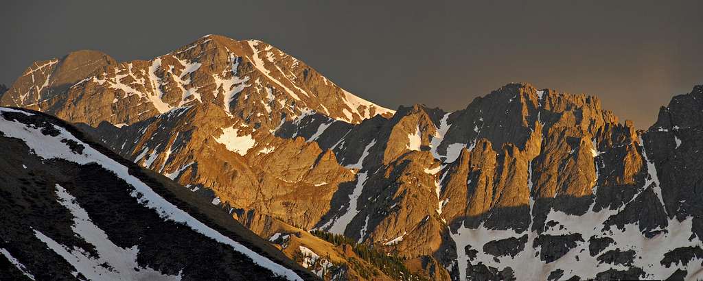
The Sangre de Cristo Mountains are one of the most distinct subranges of Colorado's Rocky Mountains. They rise as a nearly continous straight line from near Salida, Colorado and run overer 100 miles to end near Sante fe, New Mexico. They are seperated from adjacent ranges by the San Luis Valley on the west and Wet Mountain Valley on the east. The Sangre de Cristos are more rugged than their Sawatch bretheren to the north west and a distinct geology differentiates them from the San Juans to the west. The sharp peaks and solid sedimentary rock of the central Sangre de Cristos distiguishes it as a place like no other in Colorado.
The Sangre de Cristo Mountains are in large part protected by the 226,455 acre Sangre De Christo Wilderness, designated in 1993; and the Great Sand Dunes National Park. Thanks in part to the legal protections granted by the Wilderness Act large portions of the Sangres remain relatively pristine.
• Sangre de Cristo Geology: The Sangre de Cristo Mountains are a fault Block Range. Their history can be traced back to the Ancestral Rocky Mountains that rose as a chain of mountainous islands running roughly from the northeast to the southwest across Colorado 300 million years ago. As these ancient mountains were ground down by the forces of erosion, sediments carried off by ancient river systems built up large deposits in the Central Colorado Trough, a large basin between the Uncompagre Highlands and the Front Range Highlands.
In the vicinity of the Sangre de Cristos a formation called the Crestone Conglomerate was the result of the erosion of these mountains. The conglomerate is an alluvial deposit of rounded boulders, cobles, and stones imbedded in a sandstone matrix, it was dropped by swift moving streams and rivers as they exited the mountains and entered a shallow sea. It is solid and erosion resistant. Contemporaneous sedimentary deposits compose the Fountain Formation, of Red Rocks and the Flat Irons, and the Maroon Formation of the Elk Mountains. These coarse deposits were subsequently buried by younger sediments. They laid deep underground for 235 million years.
Beginning 65 million years ago the Laramide Orogeny began thrusting sections of Colorado towards the heavens. Whereas the rock of the Sawatch and Mosquito Mountains to the north bent upward as broad curves, the Sangre de Cristos first bent, then broke along several faults. As the uplift pressed the core of the Sangres against the pre-existing Wet Mountains the resulting pressure thrust the Sangres westward. The same faults that pushed the Sangres away from the Wet Mountains reactivated 26 million years ago (as the Rio Grand Rift awoke dormant faults thought Colorado, and creating all the Great Mountain Parks in the process) dropping the Wet Mountain Valley and the San Luis Valley in relation to the soaring peaks. The rocks presently exposed range from the Precambrian basement rocks in the northern and southern (Sierra Blanca) portions of the range, the central sections are composed predominantly of 300 million year old Crestone Conglomerate, and 23 million year old intrusive stocks make up the Spanish Peaks.
Beginning 1.8 million years ago and continuing up until 20,000 years ago, glaciations scoured the mountainscape. Headwalls were steepened, valleys broadened, and arêtes carved. Evidence of the action of glaciers is evident from the presence of big u-shaped valleys joined by hanging valleys, often connected by small waterfalls as at Willow Lake. It is seen in on exposed rock surfaces polished and striated by the patient motion of mountain glaciers. Moraines, piles of material glaciers eroded from the surrounding mountains and dropped as a contoured wall of debris as the glacier receded from its last advance; choke many of the drainages of the Sangre de Cristos, requiring an ascent of a steep, loose hill on route to the upper basins. These same morraines often shelter high alpine lakes which occupy the broad basins and shelves the glaciers carved. The effects of this Ice Age artistry rendered the unique geology of the Sangres into the sculpted forms that exist today.
• Flora and Fauna: The Sangres system of narrow valleys separated by rugged ridges creates a constrained ecology that seems well suited to the discreet little oases they occupy. The vegetative growth seldom shows the large old trees (except perhaps in the Huerfano River Valley) seen in the Elks or Front Range. The aspen, though abundant, are often smaller of girth and darker of bark then the massive aspen stands of the Elks or San Juans. The high peaks are frequently decorated during the summer months with a verdant velvet of grass that grows in wonderful wave patterns dictated by the geology of the rock. The flora of the Sangres is interesting for its distinct differences...
The wildlife of the Sangre de Cristos is also worth mentioning as you cannot traipse around this range long without encountering its native denizens. Marmots, Pika, and Alpine Voles are abundant in all drainages. In areas where marmots have gotten used to people, they are to be feared. Coyotes and Pine Martins prey on these animals. Elk, White tailed Deer, Bighorn Sheep, and Mountain Goats are the large herbivores. Black Bears and Mountain Lions are also present. Precautions should be taken for storing food in a manner that won't attract the bruins
![Venable Peak]()
Most of you know that the many high peaks of the linear Sangres can be approached from either the east or west. I’m here to tell you, if you are young and strong, or just into the better things in life; then I recommend an approach for these high summits from the west. And if you can, try to overnight camp up high in these wild and rugged drainages, and combine summits with an early start.
Almost all of us will approach Sangre summits from the east; in particular, the Westcliffe area, it’s just more convenient. From Denver or Colorado Springs, access is better. Overall, approaches from the east are also shorter and much more direct, thus making one day ascents more attainable, especially in winter. For the most part, an eastern trailhead will begin at around 9,000-ft, where almost all trailheads on the west will begin way down in the hot, sandy desert around 8,000-ft. My friend Jim calls this kind of day “a Sangre Death March,” not a very complimentary remark for many of us. I take nothing away from the east side of the Sangre range, for all access points will still provide a memorable experience.
However, like I said, an approach from the west means you’re into the finer things in life. And you may just be a little sick if you like this kind of lengthy torture. If you like the more rugged and less traveled stuff and you’re into insane sunsets; try an approach from the east. This side of the range gets a lot more sun than the east side. In May and June, if you like a dry snow less terrain, try an approach from the west, as opposed to the many tree-laden, post holing escapades one will encounter from the east in early spring. I can also guarantee a lot more colorful aspen viewing in fall from this side of the range, most notably the Wild Cherry, North Crestone, San Isabel and Rito Alto drainages.
![]()
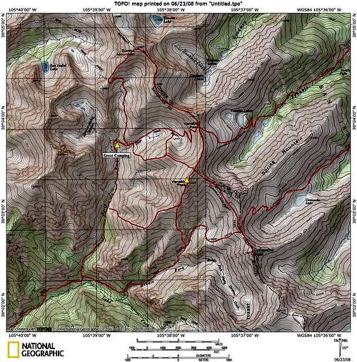
Venable Peak can be climbed using many different routes and almost all routes are easy class 2. Let’s just say there are options with this one. Winter, Spring, Summer or Fall; there will be an option for you. I have attached a map showing routes I know will work at class 3 or easier. The routes on the east side of the peak can be executed in May/June and often April depending on winter snowfall totals. The routes from the east are nice one day assaults that combine well with nice thirteeners like Eureka Mountain and Comanche Peak.
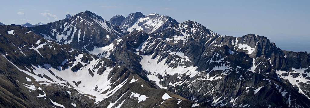
Jim and I climbed Venable Peak and combined it with Eureka Mountain (13,507-ft) with an approach from the fantastic North Crestone drainage. I made a visit to the North Crestone drainage a few years back and climbed UN13,028. While descending I promised I would come back one day with my friend Jim. The North Crestone area is awesome, on par with the South Crestone area which is easily one of the better places in the Sangres. We camped in a patch of trees around 11,375-ft (see map) and explored the pristine Groundhog Basin in the evening. We made a short hike up the tundra covered Point 12,659 and watched an amazing storm and sunset over Challenger and Kit Carson to the south.
![]()
The North Crestone Campground is very nice and I do recommend it for a quick stay. I think it’s $8.00 a night.

Venable Peak Overview
So why does Venable Peak (13,334-ft) deserve its own page on Summitpost? Because Venable’s location is primo, it’s that simple. Venable’s summit marks the spot where the Sangre Range goes from rugged beauty of the unforgettable Crestones, to the more fluid and sweeping summits of the Rito Alto, Wild Cherry and Cottonwood Peak areas. It’s your last chance moving away from the mighty Crestones to view them in their towering glory and maybe your first chance to see the new, less frequented lands to the north.
Venable’s actual summit is more different than most of it’s neighboring summits. Instead of peaking on the direct spine of the range like most of the area peaks, Venable’s summit resides about 200 yards west and lords directly over the Middle Fork and the North Fork of the North Crestone drainage. Its position makes for a great view of the mentioned drainages and allows for a straight on view of the rugged South Crestone and Crestone Peaks. This one would be a stellar summit to watch a sunset or a sunrise.
Sangre De Cristo Overview
Sangre De Christo Overview per Jon Bradford
The Sangre de Cristo Mountains are one of the most distinct subranges of Colorado's Rocky Mountains. They rise as a nearly continous straight line from near Salida, Colorado and run overer 100 miles to end near Sante fe, New Mexico. They are seperated from adjacent ranges by the San Luis Valley on the west and Wet Mountain Valley on the east. The Sangre de Cristos are more rugged than their Sawatch bretheren to the north west and a distinct geology differentiates them from the San Juans to the west. The sharp peaks and solid sedimentary rock of the central Sangre de Cristos distiguishes it as a place like no other in Colorado.
The Sangre de Cristo Mountains are in large part protected by the 226,455 acre Sangre De Christo Wilderness, designated in 1993; and the Great Sand Dunes National Park. Thanks in part to the legal protections granted by the Wilderness Act large portions of the Sangres remain relatively pristine.
• Sangre de Cristo Geology: The Sangre de Cristo Mountains are a fault Block Range. Their history can be traced back to the Ancestral Rocky Mountains that rose as a chain of mountainous islands running roughly from the northeast to the southwest across Colorado 300 million years ago. As these ancient mountains were ground down by the forces of erosion, sediments carried off by ancient river systems built up large deposits in the Central Colorado Trough, a large basin between the Uncompagre Highlands and the Front Range Highlands.
In the vicinity of the Sangre de Cristos a formation called the Crestone Conglomerate was the result of the erosion of these mountains. The conglomerate is an alluvial deposit of rounded boulders, cobles, and stones imbedded in a sandstone matrix, it was dropped by swift moving streams and rivers as they exited the mountains and entered a shallow sea. It is solid and erosion resistant. Contemporaneous sedimentary deposits compose the Fountain Formation, of Red Rocks and the Flat Irons, and the Maroon Formation of the Elk Mountains. These coarse deposits were subsequently buried by younger sediments. They laid deep underground for 235 million years.
Beginning 65 million years ago the Laramide Orogeny began thrusting sections of Colorado towards the heavens. Whereas the rock of the Sawatch and Mosquito Mountains to the north bent upward as broad curves, the Sangre de Cristos first bent, then broke along several faults. As the uplift pressed the core of the Sangres against the pre-existing Wet Mountains the resulting pressure thrust the Sangres westward. The same faults that pushed the Sangres away from the Wet Mountains reactivated 26 million years ago (as the Rio Grand Rift awoke dormant faults thought Colorado, and creating all the Great Mountain Parks in the process) dropping the Wet Mountain Valley and the San Luis Valley in relation to the soaring peaks. The rocks presently exposed range from the Precambrian basement rocks in the northern and southern (Sierra Blanca) portions of the range, the central sections are composed predominantly of 300 million year old Crestone Conglomerate, and 23 million year old intrusive stocks make up the Spanish Peaks.
Beginning 1.8 million years ago and continuing up until 20,000 years ago, glaciations scoured the mountainscape. Headwalls were steepened, valleys broadened, and arêtes carved. Evidence of the action of glaciers is evident from the presence of big u-shaped valleys joined by hanging valleys, often connected by small waterfalls as at Willow Lake. It is seen in on exposed rock surfaces polished and striated by the patient motion of mountain glaciers. Moraines, piles of material glaciers eroded from the surrounding mountains and dropped as a contoured wall of debris as the glacier receded from its last advance; choke many of the drainages of the Sangre de Cristos, requiring an ascent of a steep, loose hill on route to the upper basins. These same morraines often shelter high alpine lakes which occupy the broad basins and shelves the glaciers carved. The effects of this Ice Age artistry rendered the unique geology of the Sangres into the sculpted forms that exist today.
• Flora and Fauna: The Sangres system of narrow valleys separated by rugged ridges creates a constrained ecology that seems well suited to the discreet little oases they occupy. The vegetative growth seldom shows the large old trees (except perhaps in the Huerfano River Valley) seen in the Elks or Front Range. The aspen, though abundant, are often smaller of girth and darker of bark then the massive aspen stands of the Elks or San Juans. The high peaks are frequently decorated during the summer months with a verdant velvet of grass that grows in wonderful wave patterns dictated by the geology of the rock. The flora of the Sangres is interesting for its distinct differences...
The wildlife of the Sangre de Cristos is also worth mentioning as you cannot traipse around this range long without encountering its native denizens. Marmots, Pika, and Alpine Voles are abundant in all drainages. In areas where marmots have gotten used to people, they are to be feared. Coyotes and Pine Martins prey on these animals. Elk, White tailed Deer, Bighorn Sheep, and Mountain Goats are the large herbivores. Black Bears and Mountain Lions are also present. Precautions should be taken for storing food in a manner that won't attract the bruins
Approaching the Sangres: from east or west?
Most of you know that the many high peaks of the linear Sangres can be approached from either the east or west. I’m here to tell you, if you are young and strong, or just into the better things in life; then I recommend an approach for these high summits from the west. And if you can, try to overnight camp up high in these wild and rugged drainages, and combine summits with an early start.
Almost all of us will approach Sangre summits from the east; in particular, the Westcliffe area, it’s just more convenient. From Denver or Colorado Springs, access is better. Overall, approaches from the east are also shorter and much more direct, thus making one day ascents more attainable, especially in winter. For the most part, an eastern trailhead will begin at around 9,000-ft, where almost all trailheads on the west will begin way down in the hot, sandy desert around 8,000-ft. My friend Jim calls this kind of day “a Sangre Death March,” not a very complimentary remark for many of us. I take nothing away from the east side of the Sangre range, for all access points will still provide a memorable experience.
However, like I said, an approach from the west means you’re into the finer things in life. And you may just be a little sick if you like this kind of lengthy torture. If you like the more rugged and less traveled stuff and you’re into insane sunsets; try an approach from the east. This side of the range gets a lot more sun than the east side. In May and June, if you like a dry snow less terrain, try an approach from the west, as opposed to the many tree-laden, post holing escapades one will encounter from the east in early spring. I can also guarantee a lot more colorful aspen viewing in fall from this side of the range, most notably the Wild Cherry, North Crestone, San Isabel and Rito Alto drainages.
Routes
Venable Peak can be climbed using many different routes and almost all routes are easy class 2. Let’s just say there are options with this one. Winter, Spring, Summer or Fall; there will be an option for you. I have attached a map showing routes I know will work at class 3 or easier. The routes on the east side of the peak can be executed in May/June and often April depending on winter snowfall totals. The routes from the east are nice one day assaults that combine well with nice thirteeners like Eureka Mountain and Comanche Peak.
Jim and I climbed Venable Peak and combined it with Eureka Mountain (13,507-ft) with an approach from the fantastic North Crestone drainage. I made a visit to the North Crestone drainage a few years back and climbed UN13,028. While descending I promised I would come back one day with my friend Jim. The North Crestone area is awesome, on par with the South Crestone area which is easily one of the better places in the Sangres. We camped in a patch of trees around 11,375-ft (see map) and explored the pristine Groundhog Basin in the evening. We made a short hike up the tundra covered Point 12,659 and watched an amazing storm and sunset over Challenger and Kit Carson to the south.
North Crestone Trailhead & Camping
Getting to the North Crestone Trailhead is as easy as it gets for this side of the Sangre Range. Drive to the tiny town of Crestone. Continue on the main street another mile through town on a paved road and meet the North Crestone Campgound. The road turns to an improved dirt road to the TH. All vehicles will have zero issues getting to this TH. There is ample parking.The North Crestone Campground is very nice and I do recommend it for a quick stay. I think it’s $8.00 a night.
jfrishmanIII - Jul 2, 2008 9:41 pm - Voted 10/10
CoordinatesAwesome page, but check your coordinates. The Interactive Map feature is putting me somewhere over in the Wets.
Sarah Simon - Sep 17, 2009 2:15 pm - Voted 10/10
Coordinates are offKane, I, too, noticed the coordinates are off for this peak. The current coordinates have this peak located in the Wet Mountains, which I know is impossible, as Greenhorn (12er) is the highest point in that range. Cheers, Sarah
hgrapid - May 17, 2011 12:02 pm - Hasn't voted
Yeah, coordinates are offKane, for the past couple years, coordinates have been off. Can you address?