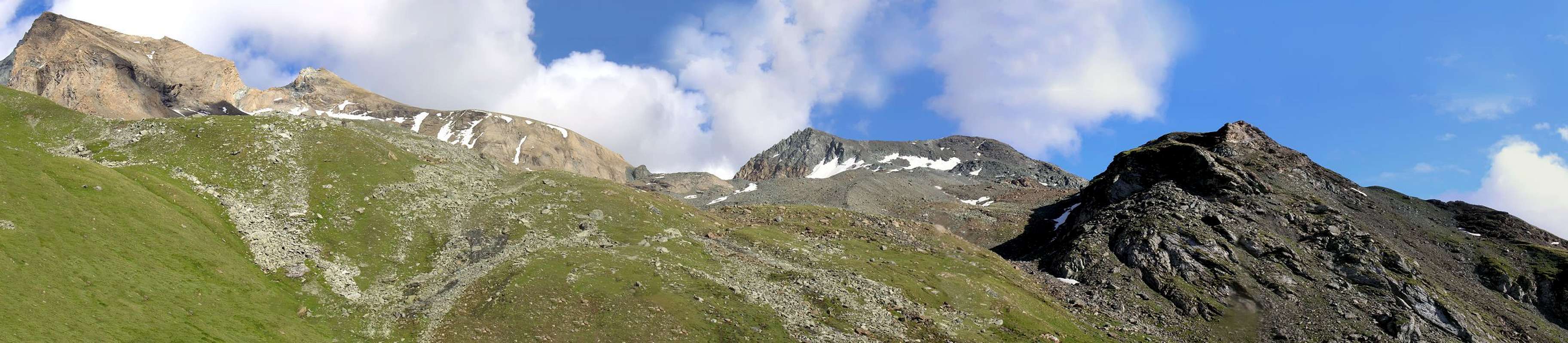
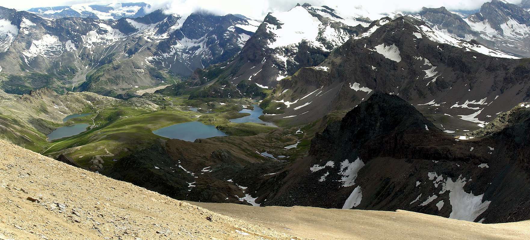
Taou Blanc, (3.438m), is an awesome natural balcony on all Gran Paradiso group, the region lakes close to Nivolet pass, and all other mountains of Val d'Aosta and Haute Savoie. When the road to Nivolet Pass is open (early June to late September) this area is very crowded. A lot of people hike to Taou Blanc, because Nivolet pass differs only 800 meters from summit. With a very wise (and too late) decision, paved road to Nivolet is closed ALL week-end days in July and August (this in 2003), to avoid further disasters. My lucky is to live here, and to choose the best period for hiking, so I suggest to wait season closure of Nivolet road, coming from Piemonte: too many people coming from cities: they don't understand what mountain is for ... ok let's talk about Taou Blanc! Drive to Pont Valsavarenche and begin this 12 hours hike, with your favourite partner and the wild animals of Parco Nazionale del Gran Paradiso: nobody else. Brief summary: two routes
1)- From Nivolet highland (coming from Pont Valsavarenche, or, with car or bus, from Nivolet Pass)
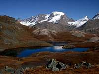
2)- From Thumel, Val di Rhêmes, crossing the lonely Vallone della Vaudaletta. Hints for photographers: all lakes in Nivolet highland are in ideal position for great sunset scenes on Gran Paradiso west face. If this hunt is interesting for you, take your time to wait last light of the day. Warm clothes will help you when sun will hide down behind Basei ridge. Keep your lens clean and ready! The two routes join together at Col di Leynir.
Il Taou Blanc (3.438 m) è un meraviglioso balcone naturale sovrastante tutto il Gruppo del Gran Paradiso, i laghi della regione vicino al passo del Nivolet e tutte le altre montagne della Val d'Aosta e dell'Alta Savoia. Quando la strada per il Colle del Nivolet è aperta (da inizio giugno a fine settembre) questa zona risulta piuttosto affollata. Molti escursionisti compiono delle escursioni al Taou Blanc, perché il Colle del Nivolet differisce solo di 800 metri di dislivello dalla cima. Con una decisione molto saggia (e troppo tardi), la strada asfaltata per il Nivolet è chiusa TUTTI i giorni del fine settimana di luglio e agosto (questo nel 2003), per evitare ulteriori disastri ambientali. La mia fortuna consiste nel vivere qui, e scegliere il periodo migliore per le escursioni; quindi consiglio di attendere la chiusura stagionale della strada del Nivolet, proveniente dal Piemonte: troppe persone arrivano dalle città: non capiscono cosa sia la montagna ... ok parliamo di Taou Blanc! Raggiungi Pont Valsavarenche e inizia questa escursione di 12 ore, con il tuo partner preferito e gli animali selvatici del Parco Nazionale del Gran Paradiso: nessun altro. Breve riassunto rivolto a due percorsi
1)- Dall'altopiano del Nivolet (con provenienza da Pont Valsavarenche, oppure, con auto o bus, dal Passo Nivolet)
2) - Da Thumel, in Val di Rhêmes, attraversando il solitario Vallone della Vaudaletta(z). Consigli per i fotografi: tutti i laghi dell'altopiano del Nivolet sono in posizione ideale per le fantastiche scene al tramonto sulla Parete Nordovest del Gran Paradiso. Se questa "caccia fotografica" ti è interessante, prenditi il tuo tempo per aspettare l'ultima luce del giorno. Vestiti caldi ti aiuteranno quando il sole si nasconderà dietro la cresta della Punta Basei. Mantieni le tue lenti pulite e pronte! I due percorsi si uniscono al Col di Leynir.
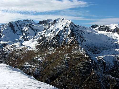
MORPHOLOGY, TOPOGRAFY and TOPONIMY This mountain is the first, starting from South also from Col Leynir (3.084m), of the triptych Taou Blanc (3.438m), Aouillé or Aouiller (3.445m, Entrelor (3.430m). A practical subdivision, linking these three mountains into a single subgroup, but arbitrary, since they all together belong to the watershed dividing the Rhêmes Valley from the Valsavaranche; which, starting from Punta Galisia (3.346m) descends South to North forming the Summits of Punta Bousson, Punta Basei, Cime di Nivoletta, Grande and Piccola Vaudala, Cime del Rosset and Punta di Leynir (3.084m). And then continuing towards the North with the Cime Pertcha or Percià, those of Gollien, the quintet of mountains of Monte Roletta (3.384m), Clocher de Djuan, Punta Bianca, Tour de Notre Dame, Punta Bioula (3.414m). Then and finally ending with Punta del Ran, Pointe Chamoussière and Mont Paillasse (2.414m) and, finally, the tiny Mont Blanc (Cabine P.N.G.P. 2.205m), above the course of the Dora Baltea. Coming to the analysis of the morphology of this mountain, it is to be observed how the same "inaugurates" that series of summits characterized by the color of the ocher-whitish yellow rock that denounce the presence of tufa rock of Triassic, hence the name such as to mean not mountain all white (since it is not), but a mountain made up of tuff rocks (as exists for the Punta and the Costa del Tuf between Cogne's Valley and Savaranche). But also a mountain with a double aspect, if observed on the South/North axis, with a first part in the South above the Col Leynir with a "good-natured" appearance and formed by a long Southwestern Slope covered with fine debris from which, in addition to some scattered block, the ascent track of the Via Normale emerges. On the other hand, the slope is more rugged with a Northern Crest that heads, dominating the Glacier de l'Aouiller, above the Colle Aouillé, while laterally they descend:
A) - instead to the East a buttress / ridge that divides into two from an altitude of 3.382 meters, just below the SE Summit (3.392 meters) with:
1) - a branch towards NE to form a buttress dominant Plan Borgnoz and in the direction of the Meyes's Coast as well as capable of forming a subsequent counterfort;
2) - to SE a long and large ridge that runs out above the Black Lake, after forming a series of six altitudes.
B) - to the West above Vaudaletta or Vaudalettaz Vallon in Rhêmes Valley.
3) - a small and elongated NW Face slides over the Northern branch of Vaudaletta or Vaudalettaz, limited by the North Crest mentioned above and
4) - a W-NW edge dividing from the already described Western Side. Finally, it should be noted that the mountain is composed of two summits with the main one to the NW, while another slightly lower (3.392 meters high) is located to the SE; from the latter, beyond the route of August 1957 or Eastern Variant and South Crest in the final part, a long rocky bastion branches off towards the SW which, after a small triangular wall, descends to Southwest, supporting the entire Southeastern Slope up to the Leynir Pass.
MORFOLOGIA, TOPOGRAFIA e TOPONOMASTICAQuesta montagna é la prima, partendo da Meridione cioé dal Col Leynir (3.084m), del trittico Taou Blanc (3.438m), Aouillé o Aouiller (3.445 m), Entrelor (3.430 m).Una suddivisione pratica, legando queste tre montagne in un unico sottogruppo, ma arbitraria, poiché le medesime tutte insieme appartengono allo spartiacque divisorio quella di Rhêmes dalla Valsavaranche; che, partendo dalla Punta Galisia (3.346 m), scende da Sud a Nord formando le Sommità della Punta Bousson, Punta Basei, Cime di Nivoletta, Grande e Piccola Vaudala, Cime del Rosset e Punta di Leynir (3.084 m), per poi proseguire verso Settentrione con le Cime Pertcha o Percià, quelle di Gollien, il quintetto di Monte Roletta (3.384 m), Clocher de Djuan, Punta Bianca, Tour de Notre Dame, Punta Bioula (3.414 m). Indi per infine concludersi con Punta del Ran, Pointe Chamoussière e Mont Paillasse (2.414 m) e, per finire, il minuscolo Mont Blanc (Casotto P.N.G.P. 2.205 m), al di sopra del corso della Dora Baltea. Venendo all'analisi della morfologia di questa montagna c'é da osservare come la stessa "inauguri" quella serie di sommità caratterizzate dal colore della roccia giallo ocra-biancastro che denunciano a presenza di roccia tufica del Triassico, donde il nominativo tale da significare non montagna tutta bianca (poiché non lo é), bensì montagna composita da rocce tufiche (come esiste per la Punta e la Costa del Tuf tra la Valle di Cogne e la Savaranche). Ma anche una montagna dal duplice aspetto, se osservata sull'asse Sud/Nord, con una prima parte a Sudovest sopra il Col Leynir dall'aspetto "bonario" e formata da un lungo pendio Sudovest ricoperto da fine detrito dal quale, oltre a qualche blocco sparso, emerge la traccia di salita della Via Normale. All'opposto invece il versante é più dirupato con una Cresta Nord che s'indirizza, dominando il Glacier de l'Aouiller, sopra il Colle dell'Aouillé, mentre lateralmente scendono:
A) - ad Oriente un contrafforte / crestone che si divide in due dalla quota 3.382 metri, appena al di sotto della Punta SE (3.392 metri) con:
1) - un ramo verso NE in direzione della Costa delle Meyes, nonché atto a formarne un secondo contrafforte dominante Plan Borgnoz;
2) - verso SE invece una lunga e grande cresta che si esaurisce al di sopra del Lago Nero, dopo aver formato una serie di sei quote.
B) - ad Occidente verso ed al di sopra del Vallone della Vaudaletta oppure Vaudalettaz in Val di Rhêmes.
3) - una piccola ed allungata Parete NO scivola sopra il ramo Settentrionale della Vaudaletta o Vaudalettaz, limitata dalla Cresta Nord di cui sopra e da
4) - uno spigolo O-NO divisorio dal già descritto Versante Ovest. Infine da annotare come la montagna sia composta da due sommità con la principale a NO, mentre un'altra di poco inferiore (alta 3.392 metri) é collocata a SE; da quest'ultima, oltre la via dell'agosto 1957 o Variante Orientale e Cresta Sud nella parte terminale, si diparte verso SO una lunga bastionata rocciosa che, dopo una paretina triangolare, scende in direzione SO sostenendo l'intero Versante Sudest insino al Col Leynir.
First ascents
First on the summit: Engineer Pio Paganini, (? ?th, 1880); in ascent from Nivolé Tableland and, probably, Leynir Pass.
In winter: unknown.
SW Slope (Normal Route from Leynir Pass): unknown.
Western Variant (West Slope and South Crest in final): unknown; in ascent directly by Rhêmes N. Dame, Thumel, Vaudaletta Vallon but avoiding Leynir Col.
W-NW Edge: Osvaldo and Alessandro Cardellina, (Jun 20th, 1990) in ascent from Thumel, Vaudaletta Alps, Vaudalettaz's Middle side; in descent to Leynir Pass.
NW Wall: Osvaldo Cardellina, lone, (Aug 21th, 1971); in ascent from Thumel, Vaudalettaz's Alps and Northern side; in descent SO Slope to Col Leynir, Thumel.
Northern Crest (from Aouillé or Aouiller Pass): Giovanni Bobba with Rhêmes Mountain Guide Casimiro Therisod, (Aug 07th, 1889); in ascent from Rhêmes Notre Dame Municipality, Thumel Village, Vaudaletta Pastures in Vaudalettaz's Vallon in Middle side and through Aouillé or Aouiller Pass.
NE Spur/Edge: Osvaldo Cardellina and Marco Cossard, (Jul 30th, 1978); in ascent from Pont, Plan Borgno; in descent by SW Slope to Alp in Nivolé's Vallon.
S-SE Ridge (integrally from Lago Nero): Osvaldo Cardellina and Marco Cossard, (Aug 24 or 25th, 1982); in ascent from Pont, Plan Borgno, Lago Nero, quotas 2.974m, 3.201m, 3.291m, 3.363m, 3.382m, 3.392m; in descent by Southwestern Slope to Leynir Pass and from this to Lago Nero, Plan Borgno in Nivolé's Vallon.
SE Face of SE Summit (3.392m) and South Crest in final part: Osvaldo Cardellina, solo, (Aug 02th, 2007); in ascent from Pont, Croce dell'Arollay, Nivolé Tableland, Lago Nero, pond (2.922m); in descent to Leynir Pass, Trebecchi, Rosset and Leytà Lochs, Savoia and Città di Chivasso Shelters, Nivolet's Alp, Pont.
Eastern Variant (East Slope and South Crest in terminal part): unknown or Nino Daga Demaria, (Aug 02th, 1957); in ascent from Città di Chivasso Shelter, Rosset, Trebecchi Lochs above Nivolet or Nivolé Tableland and in terminal sector bypassing in East Leynir Col; in descent towards Leynir Pass, lochs and refuge.
Getting There
Valsavarenche and Rhêmes Notre Dame route. Common begin: Introd village. Bus station for Rhêmes Notre Dame. *** From Turin/Milan. Motorway A5, exit in Aosta Ovest. Follow Courmayeur direction, until reached Villeneuve. Follow for Val di Rhêmes direction. *** From Switzerland, Martigny (Grand St. Bernard Tunnel/Pass). Drive to Aosta, then follow Courmayeur direction on SS.26. Once reached Villeneuve, turn for Val di Rhêmes. *** From France (Mont Blanc Tunnel or Petit St. Bernard Pass). Do not enter in motorway A5, drive through SS.26 Aosta direction. Before arriving in Villeneuve, turn right for Val di Rhêmes direction. From Introd. 2 km far from Introd there is a crossroads: left to Valsavarenche, right to Val di Rhêmes. *Valsavarenche. Drive until road ends, in Pont Valsavarenche, (1.960m). Big park (same for Gran Paradiso, via Vittorio Emanuele Hut). * Val di Rhêmes. Drive until road ends, in Thumel, (1.789m) (Gian Federico Benevolo Hut). How to get to Nivolet Pass, road access through Ceresole Reale (Piemonte). *** From France (Tunnel Mont Blanc, Petit St. Bernard) and Switzerland, Martigny (via Tunnel or Grand St. Bernard Pass): motorway A5, exit in Ivrea. Follow for Castellamonte or Cuorgnè then Ceresole Reale or Parco Nazionale del Gran Paradiso. *** From Turin. Motorway A5, exit in Scarmagno. Follow for Castellamonte, then Cuorgnè, then Ceresole Reale or Parco Nazionale del Gran Paradiso. *** From Milan. Motorway A4, after Santhià exit, turn to Aosta direction (A5 motorway). Once arrived on A5, following Aosta direction first exit is Ivrea, while following Turin direction first exit is Scarmagno. Best one (easier road) is Ivrea. Road to Nivolet Pass access restricted: road open only from June to end of September. Saturday and Sunday, bus mandatory from Serrù dike (bike are allowed).
Percorso dalla Valsavarenche e Rhêmes Notre Dame. Inizio comune da Introd. Stazione degli autobus per Rhêmes Notre Dame. *** Da Torino/Milano. Autostrada A5, uscita Aosta Ovest. Seguire la direzione per Courmayeur, fino a raggiungere Villeneuve. Seguire la direzione per la Valle di Rhêmes. *** Dalla Svizzera, Martigny (Grand St. Bernard Tunnel/ass). Raggiungere Aosta, quindi seguire la direzione per Courmayeur sulla SS.26. Una volta raggiunto Villeneuve, svoltare per la Valle di Rhêmes. *** Dalla Francia (Tunnel del Monte Bianco o Colle del Petit San Bernardo). Non entrare in autostrada A5, seguire SS.26 direzione Aosta. Prima di arrivare a Villeneuve, girare a destra in direzione la Valle di Rhêmes. Da Introd. A 2 km da Introd si trova un bivio: a sinistra in per la Valsavarenche, a destra per la Valle di Rhêmes. * Valsavarenche. continuare fino alla fine della strada, a Pont Valsavarenche, (1.960 m). Grande parcheggio (Rifugio Vittorio Emanuele). * Val di Rhêmes. Continuare fino a Thumel, (1.789 m) Grande parcheggio per (Rifugio Gian Federico Benevolo). Come raggiungere il Colle del Nivolet, accesso stradale attraverso Ceresole Reale (Piemonte). *** Dalla Francia (Tunnel Mont Blanc, Colle del Petit St. Bernard) e Svizzera, Martigny (via Tunnel o Grand St. Bernard Pass): autostrada A5, uscita Ivrea. Seguire per Castellamonte o Cuorgnè poi Ceresole Reale o Parco Nazionale del Gran Paradiso. *** Da Torino. Autostrada A5, uscita a Scarmagno. Seguire per Castellamonte, poi per Cuorgnè, poi per Ceresole Reale o per Parco Nazionale del Gran Paradiso. *** Da Milano. Autostrada A4, dopo l'uscita Santhià, svoltare in direzione Aosta (autostrada A5). Una volta arrivati sulla A5, seguendo la direzione Aosta, prima uscita è Ivrea, mentre seguendo la direzione Torino, la prima uscita è Scarmagno. Accesso stradale al Colle del Nivolet: strada aperta solo da giugno a fine settembre. Sabato e domenica, autobus obbligatorio da Serrù dike (bici consentite).
Route
From Rhêmes Notre Dame drive to the ancient Village of Thumel (1.879m; wide square in the ground to use parking just before) shortly descend to the wooden bridge over the Dora di Rhêmes and immediately after crossing the Torrent Vaudalettaz on a walkway Wood. Continue along path n° 11 with very tight hairpin bends crossing a beautiful forest next to a waterfall well in sight and then, with a more open path, reach the Alpe Vaudalettaz (2.443 m) which is discarded on the left (North); dubbing a grassy ridge instead reach the Casotto of P.N.G.P. (also Cabin, 2.480m). Leave it behind and continue, just high up the valley, East-northeast following the Torrent Vaudalettaz up to the at an altitude of 2.574 meters. Just a hundred yards beyond cross a secondary branch of the same at an altitude of about 2.700 meters. Not long after the trail, still following the bottom of the valley, it changes direction first in the East and then decidedly towards Meridione passing at the foot of the Aouillé or Pointe de l'Aouille (3.445m), the homonymous hill (3.327m) and the Western Wall of the Taou Blanc up to the Colle del Leynir (3.084m), where it joins the path n° 3B; this last goes up from Pont di Valsavarenche along the lakes road or Lochs Leytà, Rosset (2.700 meters) and Chanavey (2.846m). From this hill a very small trail, again with the n° 11, goes in North up to the Top overcoming wide and easy sloping slopes of low slope up to small yellowish summit rocks (F, from 4 to 5 hours).
Da Rhêmes Notre Dame raggiungere in auto l'antico Villaggio di Thumel (1.879 m; ampio piazzale in terra ad uso parcheggio appena prima) scendere in breve al ponte in legno sopra la Dora di Rhêmes e subito dopo attraversare il Torrent Vaudalettaz su di una passerella in legno. Continuare con il sentiero n° 11 con strettissimi tornanti attraversando un bel bosco a fianco di una cascata bene in vista per poi, con un percorso più aperto, raggiungere l'Alpe Vaudalettaz (2.443 m) che si scarta sulla sinistra (Nord); doppiando un costone erboso raggiungere invece il Casotto del P.N.G.P. (2.480 m). Lasciarlo alle spalle e continuare, appena alti sulla valle, verso Est-nordest seguendo il Torrent Vaudalettaz fono all'altitudine di 2.574 metri. Appena un centinaio di metri oltre attraversare un ramo secondario del medesimo in quota 2.700 metri circa. Non molto dopo il sentiero, sempre seguendo il fondo del vallone, cambia direzione dapprima in Est e poi decisamente verso Meridione passando ai piedi dell'Aouillé o Pointe de l'Aouille (3.445 m) , dell'omonimo colle (3.327 m) e della Parete Occidentale del Taou Blanc fino a raggiungere il Colle del Leynir (3.084 m), dove si congiunge con il sentiero n° 3B; questo ultimo sale da Pont di Valsavarenche lungo la via dei Laghi Leytà, Rosset (2.700 metri circa) e Chanavey (2.846 m). Da questo colle un sentierucolo, sempre con il n° 11, sale a Settentrione verso la Vetta superando ampli e facili pendii detritici di scarsa pendenza fino alle roccette giallognole sommitali (F; dalle 4 alle 5 ore)
Red Tape
All routes are within Parco Nazionale del Gran Paradiso. Dogs or other animals are not allowed. Camping is strictly forbidden (except for emergency from sunset 'til dawn). Any fees required nor parking permits. Ceresole Reale - Nivolet Pass paved road. Seasonal open from early June to end of September. During Sat and Sun in July and August, engin veichles (cars, campers and motorbike) must stop in Serrù dike park station. Bus mandatory to Nivolet pass.Tutti i percorsi si trovano all'interno del Parco Nazionale del Gran Paradiso.
Cani o altri animali non sono ammessi. Il campeggio è severamente vietato (tranne che per le emergenze dal tramonto fino all'alba). Ceresole Reale - Strada asfaltata del Colle del Nivolet. Apertura stagionale da inizio giugno a fine settembre. Durante il sabato e la domenica nei mesi di luglio e agosto, i veicoli (macchine, camper e moto) devono fermarsi nel pressi del lago Serrù. Bus obbligatorio per il Colle del Nivolet.
When To Climb
Hiking: from late June until end of September. For lucky people: from 1st 'til 15th October, if snow let you. Ski mountaineering: from late March 'til late May. Perfect assested snow required. From Thumel, Val di Rhêmes, BS+, 5h'00.
Escursionismo: da fine giugno a fine settembre. Scialpinismo: da fine marzo fino a fine maggio. Da Thumel, Valle di Rhêmes, BS+, 5h’00.
Camping
Strictly forbidden in Parco Nazionale del Gran Paradiso.
Mountain Conditions
You can get meteo information at the official site of the Regione Valle d'Aosta:
"Guida dei Monti d'Italia-Gran Paradiso Parco Nazionale" E. Andreis, R. Chabod, M. C. Santis, Club Alpino Italiano/Touring Club Italiano, prima Ed. 1939; seconda Ed. 1963; terza Ed. 1980.
"I Rifugi della Valle d'Aosta" di Stefano Ardito, Ed. Guide iter, Febbraio 2003.
"Diari Alpinistici" di Osvaldo Cardellina e Indice Generale accompagnato da Schedario Relazioni Ascensioni 1964-2019 (inediti).
MAPS:
Kompass "Gran Paradiso Valle d'Aosta Sentieri e Rifugi" Carta Turistica 1:50.000.
Enrico Editore Ivrea-Aosta "Gruppo del Gran Paradiso" 1:50.000.
I.G.C. Istituto Geografico Centrale Torino "Valsavarenche Val di Rhemes Valgrisenche Parco Nazionale del Gran Paradiso", (carta n° 102), 1:25.000.
I.G.C. Istituto Geografico Centrale Carta dei sentieri e dei rifugi "Il Parco Nazionale del Gran Paradiso" 1:5.0000.
Children refers to the set of objects that logically fall under a given object. For example, the
Aconcagua mountain page is a child of the 'Aconcagua Group' and the 'Seven Summits.' The
Aconcagua mountain itself has many routes, photos, and trip reports as children.
Parents refers to a larger category under which an object falls. For example, theAconcagua mountain page has the 'Aconcagua Group' and the 'Seven Summits' asparents and is a parent itself to many routes, photos, and Trip Reports.


 23866 Hits
 90.47% Score
 32 Votes