
-
 6044 Hits
-
 82.48% Score
-
 15 Votes
|
|
Mountain/Rock |
|---|---|
|
|
46.08419°N / 8.86584°E |
|
|
Hiking, Skiing |
|
|
Spring, Summer, Fall, Winter |
|
|
6352 ft / 1936 m |
|
|
Overview
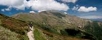
 Monte Gradiccioli (back) seen from La Traversata Monte Gradiccioli (back) seen from La Traversata |
Switzerland's southernmost canton (state), Ticino / Tessin is formed like a southward-pointing arrowhead. The tip runs out in the area between three of the big northern Italian (and southern Swiss) lakes Lago di Como (completely on Italian soil), Lago di Lugano and Lago Maggiore. Between the latter two is a small mountain range which is home to one of Switzerland's most scenic ridge traverses, known by the simple name of La Traversata to the locals. Since the border between the two countries crosses the range (in a rather confusing pattern) it is either counted among the Ticino Alps or the Prealpi Lombarde depending on your point of view. The traverse connects Monte Lema in the south with Monte Tamaro in the north, passing by virtually all other peaks (which, however can be easily hiked to with short detours. Both endpoints are served by cable-cars so that on a fine summer day you can count on big crowds enjoying the scenery.
The ridge consists of eight named summits, the highest of which is Monte Tamaro in the north. Right behind it, only 30m lower, follows its neighbour Monte Gradiccioli. Both Tamaro and Gradiccioli nearly reach the 2000m mark and are clearly taller than their direct neighbours. Therefore you have an open view ranging from Monte Rosa in the west to the Bernina Group in the east with long sections of the Alpine main ridge visible to the north. The three lakes can be seen and on clear days you can look far into the north Italian plains in the south.
 |  |  |
Monte Gradiccioli is a three ridged mountain. The north ridge connects it with Monte Tamaro, the south ridge with Monte Pola, the east ridge curves all the way down to Lago Lugano, 1500m below. Like most of the ridge of La Traversata Monte Gradiccioli is above the timberline and only small bushes like dwarf pines or alpine roses grow there, another reason for the famed views. In late spring / early summer you encounter large patches of alpine roses covering the mountain in red and green.
 |  |  |
As mentioned above, the hiking trail for La Traversata ignores Monte Gradiccioli, and passes to the west some 150m beneath the summit. However, there are well trodden paths along the north and south ridges, which join forces some 50m southwest of the top. The northern ascent in particular is rather steep and offers some fine views into the small (100m) north face of the mountain. The east ridge ascent, while not difficult, is reserved to enduring hikers as - depending on where you start - you'll have to scale a lot of elevation gain. Moreover, being not as popular as La Traversata, the east ridge path is more difficult to find.
Panoramic Views
Though we had perfect weather for the whole day we hiked La Traversata, a cloud of differing shape and size was almost constantly hovering around Monte Gradiccioli. During our 10 minutes on the topviews were open only to the west and north. Therefore instead of one 360° panorama you'll find two panoramas (one in the Red Tape section) here covering the open angle.  |
Getting There
 Monte Gradiccioli seen from the saddle which separates it from Monte Tamaro
Trailheads for Monte Gradiccioli are the two endpoints of La Traversata, the cable cars to Monte Lema from Miglieglia and to Alpe Foppa from Rivera. In addition, there is the east ridge route, which most reasonably can be started at Monti di Toricella. All three starting points are located to the east of the ridge close to motorway A2.
- For the Rivera trailhead leave at the exit Rivera and follow the signs to the cable-car.
- For Monti di Torricella also leave at the exit Rivera and follow B2 southward to Torricella. Take Via alla Cava to the right until you reach the church. There a small mountain roads heads up to Monti di Torricella.
- For Miglieglia leave to motorway at the exit Lugano Nord but follow the signs to Breno. In Breno follow the signs to Miglieglia and the cable-car to Monte Lema.
Red Tape
 |
The whole of La Traversata is located on Swiss ground but gets very close to the Italian border in some places. Be sure to carry a valid ID. Apart from that there are no restrictions or regulations.
Accommodation
There is plenty of accommodation to be found on the web, mainly apartments or holiday homes. However, Tessin / Ticino has become very expensive so you will have to carefully plan your vacation. Most expensive are the cities (Lugano, Locarno, Ascona) but also the villages on the shores of the lakes can burn deep holes in your pockets. In general the higher up and the better the view the more expensive.A good alternative is agritourismo - farm holidays, either in the valleys or in one of the spring / autumn settlements at an elevation of around 1000m.
You can find accomodation of any type using the following url:
http://www.ticino.ch
Weather Conditions
Maps & Books
Maps
- Digital Maps
- Regular Maps
- Malcantone
Carta Escursionistica 286 T
Ufficio Federale di Topografia Swizzeria
1:50.000
ISBN: 9783302302867
- Malcantone
Books
- Tessin
M. Hempel
Kompass Guidebook WF997
Kompass Verlag
ISBN: 3-85491-771-6
- Tessin
H. Bauregger
Rother Verlag
ISBN: 978-3-7633-4078-1
- Tessin
E.E. Hülsler
Bruckmann Verlag
ISBN: 978-3-7654-3653-6