

-
 9403 Hits
-
 88.61% Score
-
 27 Votes
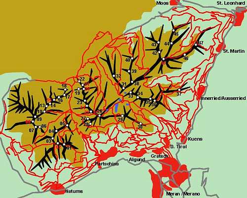
|
|
Area/Range |
|---|---|
|
|
46.72635°N / 11.07394°E |
|
|
Hiking, Mountaineering, Mixed, Scrambling, Via Ferrata, Skiing |
|
|
Spring, Summer, Fall, Winter |
|
|
10948 ft / 3337 m |
|
|
1 - Overview
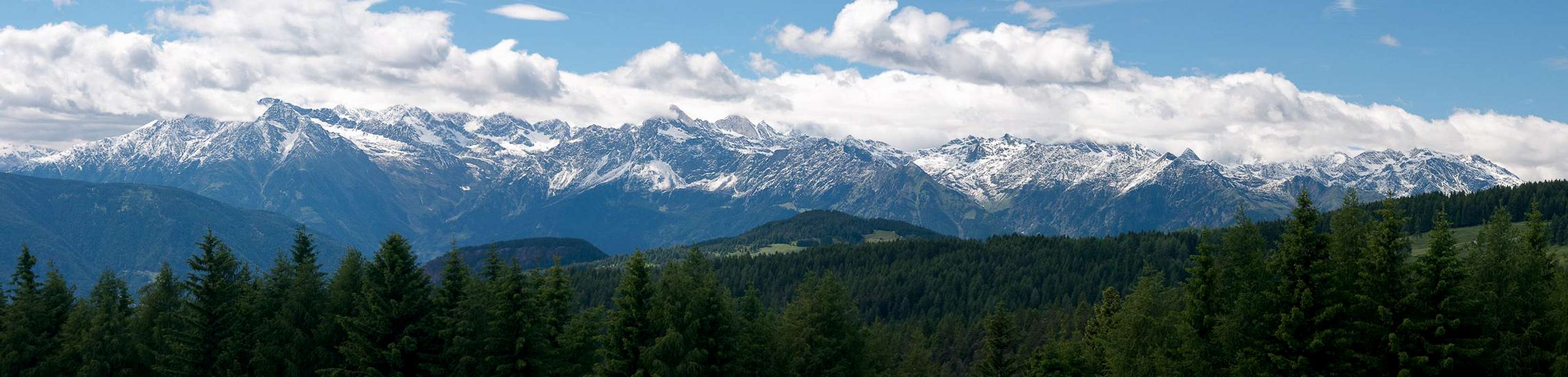
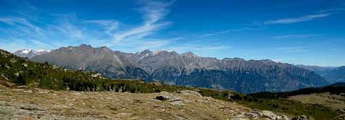
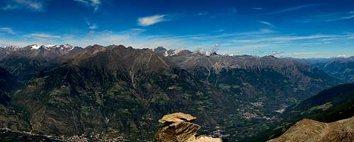 Texel Group / Gruppo di Tessa seen from Naturnser Hochwart |
The Ötztal Alps are among the largest mountain groups of the eastern Alps. They stretch between Reschenpass / Passo di Resia in the west and Timmelsjoch / Passo del Rombo in the east. Since the main ridge of the group at the same time is the border between Italy and Austria, the group has supgroups in both countries. Of the three Italian groups - that is the ones fully on Italian soil - the most important one is the easternmost one: the Texel Group / Gruppo di Tessa.
Surrounded by profound valleys on all sides, the Texel Group / Gruppo di Tessa has only one real connection to the remainder of the Ötztal Alps, which is Eisjöchl, a pass between Pfossental / Val di Fosses and Pfelderer Tal / Val di Plan, which connects the group to the Ötztal Alps Main Ridge in the north. The eastern boundary is Passeiertal / Val Passiria, the southern one Vinschgau / Val Venosta, while the western boundary is Schnalstal / Val Senales. In between these boundaries a rather complex mountain range rises up to 3300+m scaling an elevation difference of roughly 3000m!
 Hohe Weiße and Lodner |  Texelspitze | 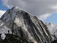 Hohe Weiße |
The Texel Group / Gruppo di Tessa itself divides into three parts:
- A western subgroup, which is separated from the rest of the larger group by Zieltal Valley. It again can be divided into two parts: a northern part around Texelspitze / Cima Tessa and Roteck / Monte Rosso, the highest mountains of the whole range and a southern part around Zielspitze / Cima di Tel, Kirchbachspitze / Croda del Clivo and Gfallwand / Croda del Tovale.
- A central ridge starting at Eisjöchl and running across Hohe Weisse / Cima Bianca Grande, Lodner / Cima Fiammante and Tschigat / Cigot towards Mutspitze / Monte Mutta.
- An eastern subgroup with many valleys draining into Pfelderer Tal / Val di Plan and Passeiertal / Val Passiria which culminates in Rötenspitze and Kolbenspitze / La Clava
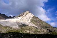 Lodner |  Grafspitze summit | 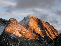 Hohe Weiße |
Among hikers the Texel Group / Gruppo di Tessa is best known for its four to six day "trekking" trail Meraner Höhenweg / Alta Via di Merano, which loops around the group completely. In its southern part the trail traverses the south slopes af the group at 1000 - 1500m, always with a good view across Vinschgau / Val Venosta. This part is extremely popular with day hikers since there are a good number of inns along the way and you don't have to hike more than two hours to get the next refreshment. In its northern part, however, Meraner Höhenweg heads up to almost 3000m when it crosses Eisjöchl requiring more than just a little experience in high altitude terrain.
Additionally there are two south - north crossings of the group, both taking two days. One starts at Partschins /Parcines and heads up through Zieltal to Lodner Hütte / Rifugio Cima Fiammante, from where a traverse of Johannesscharte leads into Pfossental / Val di Fosses. The second traverse starts at Dorf Tirol / Tirolo, heads up Spronser Tal / Valle di Sopranes to a beautiful high plain with numerous lakes (Spronser Seen / Laghi di Sopranes). It then crosses Spronser Joch to descend to Lazinser Alm in Pfelderer Tal / Val di Plan.
 Texel Group from Hochwilde |  Sefiarspitze |  View down the Roteck E ridge |
Ignoring the half dozen mountains (mainly in the south and east) which can be ascended by hiking trails, most of the mountains of the Texel Group / Gruppo di Tessa are reserved for scramblers, mountaineers and climbers. Much of the group - especially its centre - is lonely and solitary, a stark contrast to the activity and traffic on Meraner Höhenweg - or the city of Meran / Merano itself.
2 - Texel Group / Gruppo di Tessa on SP
  |
- Texel Group / Gruppo di Tessa
- Kirchbachspitze / Croda del Clivo
- Roteck / Monte Rosso
- Hohe Weiße / Cima Bianca Grande
- Lodner / Cima Fiammante
- Gfallwand / Croda del Tovale
- Tschigat / Cigot
- Lazinser Rötelspitze / Cima Rosa
- Spronser Rötelspitze / Cima Rosa
- Mutspitz / Monte Muta
- Sefiarspitze / Monte Tavolino
- Kolbenspitze / La Clava
- Blasiuszeiger / Monte di Biagio
- Muthspitze / Punta della Motta
3 - The Summits
- Zielspitze / Cima di Tel (3009m)
- Kirchbachspitze / Croda del Clivo (3081m)
![]()
- Gfallwand / Croda del Tovale (3175m)
![]()
- Schwarze Wand / Croda Nera (3065m)
![]()
- Blasiuszeiger / Monte di Biagio (2837m)
![]()
- Auf dem Kreuz / Alla Croce (3163m)
- Gingglspitze / Cima Cenge (3140m)
- Blaulackenspitze / Cima del Lago Azurro (3173m)
- Texelspitze / Cima Tessa (3318m)
![]()
- Roteck / Monte Rosso (3337m)
![]()
- Südlicher Roter Kamp / Cima Rossa Sud (3250m)
- Nördlicher Roter Kamp / Cima Rossa Nord (3258m)
- Südliche Rote Wand / Croda Rossa Sud (3254m)
- Nördliche Rote Wand / Croda Rossa Nord (3184m)
- Trübwand / Croda di Ritorbo (3264m)
![]()
- Schwarzwand / Croda Nera (3170m)
- Schrottner / Croda Rotta (3023m)
- Kleiner Schrottner / Croda Rotta / Piccola (2998m)
3.2 - Central Ridge
- Kleine Weisse / Cima Bianca Piccola (3059m)
- Hohe Weisse / Cima Bianca Grande (3278m)
![]()
- Grafspitze / Cima della Grava (3147m)
![]()
- Schnalsberg / Monte di Senales (3001m)
- Lodner / Cima Fiammante (3228m)
![]()
- Hochkarjochspitze (3098m)
- Lazinser Rötelspitze / Cima Rosa (3037m)
![]()
- Tschigat / Cigot (2998m)
![]()
- Plattenspitze / Punta delle Laste (2828m)
- Sattelspitze (2426m)
![]()
- Spronser Rötelspitze / Cima Rosa (2625m)
![]()
- Mutspitze / Monte Mutta (2295m)
![]()
3.3 - Eastern subgroup
- Schieferspitze / Monte Lavagna (2813m)
- Erenspitze / Punta dell'Onore (2760m)
![]()
- Schwarzkopf / Cima Nera (2804m)
- Schwarzkogel / Col di Vallarga (2668m)
- Moosbichl (2541m)
- Spitzhorn (2528m)
- Sattelspitze (2134m)
- Rötenspitze (2875m)
![]()
- Ulsenspitze / Punta di Ulsen (2736m)
- Sefiarspitze / Monte Tavolino (2846m)
![]()
- Kolbenspitze / La Clava (2868m)
![]()
- Mulsspitze (2621m)
- Hütterberg (2407m)
- Hohe Wand (2358m)
- Platter Berg (2230m)
- Muthspitze (2264m)
![]()
- Matatzspitze (2179m)
![]()
3.1 - Western subgroup


4 - Getting There
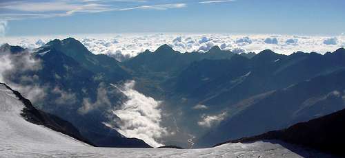
Pfossental / Val di Fosses, seen from Similaun
The city of Meran / Merano is the main touristic centre in the area and a good starting point for activities in the Texel Group / Gruppo di Tessa. It is most easily reached from Bozen / Bolzano via SS38. However, there are other, sometimes longer but always more beautiful itineraries.
- Quick access (southern access)
- Take Berenner Motorway A22 to Bozen Süd / Bolzano Sud
- Switch to SS38 to Meran / Merano and onwards into Passeiertal / Val Passiria or Vinschgau / Val Venosta
- Reschenpass / Passo di Resia (north-western access)
- From Austria take B180 from Landeck, which at the border turns into SS40.
- From Switzerland take B27 through Unterengadin to the border at Schalkl, where it meets B180, Reschenpassstrasse.
- At Schluderns / Sluderno turn onto SS38 to Meran / Merano
- Timmelsjoch / Passo del Rombo (northern access)
- In Austria take Inntalautobahn A12 to the exit Ötz
- Turn onto B186 south through Ötztal Valley.
- At the end of the valley the road climbs steeply to Timmelsjoch / Passo del Rombo, where you cross the border to Italy.
- Take SS44 bis to St. Leonard / San Leonardo.
- Turn onto SS44 to Meran / Merano.
- Jaufenpass / Passo di Giove (north-eastern access)
- Take Brenner Motorway A22 to Sterzing / Vipiteno
- Turn onto SS44 across Jaufenpass / Passo di Giove all the way to Meran / Merno
5 - Accommodation
There are four mountain huts and one bivouak in the Texel Group / Gruppo di Tessa (see Ötztal Alps Page for more information)- Hochganghaus (1839m)
- Lodnerhütte (2259m)
- Stettiner Hütte (Eisjöchlhütte) (2875m)
- Bockerhütte (1717m)
- Guido Lammer Biwak (2707m)
- Vinschgau / Val Venosta accommodation
- Passeiertal / Val Passiria accommodation
- Schnalstal / Val Senales accommodation
6 - Red Tape
The whole Texel Group / Gruppo di Tessa (in addition to the eastern part of the Ötztal Alps Main Ridge) has been protected by Naturpark Texelgruppe / Parco Naturale Gruppo di Tessa. The park was established in 1976 and contains an area of 33430 ha. The usual restrictions apply.7 - Weather Conditions
The Texel Group / Gruppo di Tessa from the base of Staffelsberg
8 - Maps and Books
8.1 - Maps
- Regular Maps
- Naturpark Texelgruppe - Meraner Höhenweg
Kompass Map WK043
1:25000
ISBN: 3-85491-390-7
- Passeiertal / Val Passiria
Tabacco Map 039
1:25000
ISBN: 978-8883150395
- Meran und Umgebung / Merano e dintorni
Tabacco Map 011
1:25000
ISBN: 978-8883150111
- Schnalstal / Val Senales - Naturns / Naturno
Tabacco Map 004
1:25000
ISBN: 978-8883150043
- Naturpark Texelgruppe - Meraner Höhenweg
- Digital Maps
8.2 - Books
- Ötztaler Alpen
W. Klier
Alpenvereinsführer
Rother Verlag
ISBN: 3-7633-1123-8
- Rund um Meran - Passeiertal, Texelgruppe, Ultental
Henriette Klier
Rother Verlag
ISBN: 978-3763342907
- Vinschgau
Henriette Klier
Rother Verlag
ISBN: 978-3-7633-4205-1
- Rund um Meran
Kompass Book WF 5704
Franziska Baumann
Kompass Verlag
ISBN: 978-3-85026-236-1