-
 8813 Hits
-
 90.81% Score
-
 33 Votes
|
|
Mountain/Rock |
|---|---|
|
|
45.95061°N / 7.00288°E |
|
|
Haute Savoie |
|
|
Trad Climbing, Sport Climbing |
|
|
Spring, Summer |
|
|
10030 ft / 3057 m |
|
|
Overview
Aiguille du Refuge m. 3057
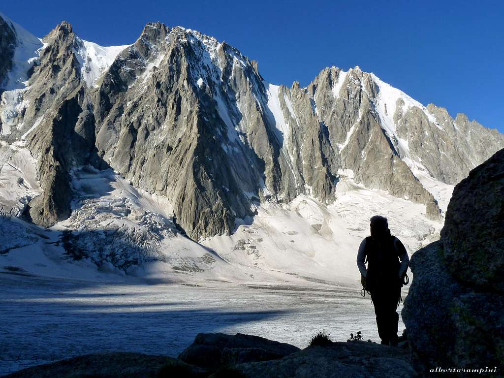
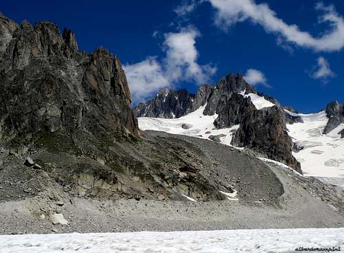
Aiguille du Refuge is one of the rocky satellites of Aiguille d’Argentière, built in the superb Mont Blanc reddish granite and lying on the right orographic side of Glacier d’Argentiere, opposite to the famous stunning mountain scenery given by Mont Dolent and Triolet on the left and by the majestic Northern faces of Les Courtes, Les Droites and Aiguille Verte, just in front of. On the South wall of this sunny and amazing peak run different routes, but the best known and the classic one is “Le Gateau de Riz”, a medium grading trad climb on first class granite. The scenery is absolutely breathtaking; for this reason, the quality of the rock and the closeness to the Refuge d’Argentiere the route is often attended, even in late winter or early spring, approaching it by skies.
Getting There
Road access
The starting point is the village of Argentière m. 1240 . The main road approachs to Argentière are:
- From Chamonix follow the road towards NE in the direction of France-Switzerland border, quickly getting to the village of Argentière (8 km. from Chamonix)
From Switzerland
- Starting from Martigny: follow the road getting to the Switzerland – France border, pass the border, getting to the village of Argentière (37 km. from Martigny, 5 km. from the border).
- Starting from Geneve: follow the E25 Motorway to St. Gervais les Bains, then the RN 205 to Chamonix and Argentière
From Italy
- From Aosta follow the E25 Motorway to Courmayeur, then enter the Mont Blanc Tunnel getting to Chamonix, then Argentière (73 km. from Aosta)
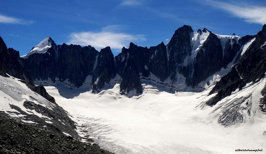
Approach on Glacier d’Argentiere
Approach to the Refuge d’Argentière
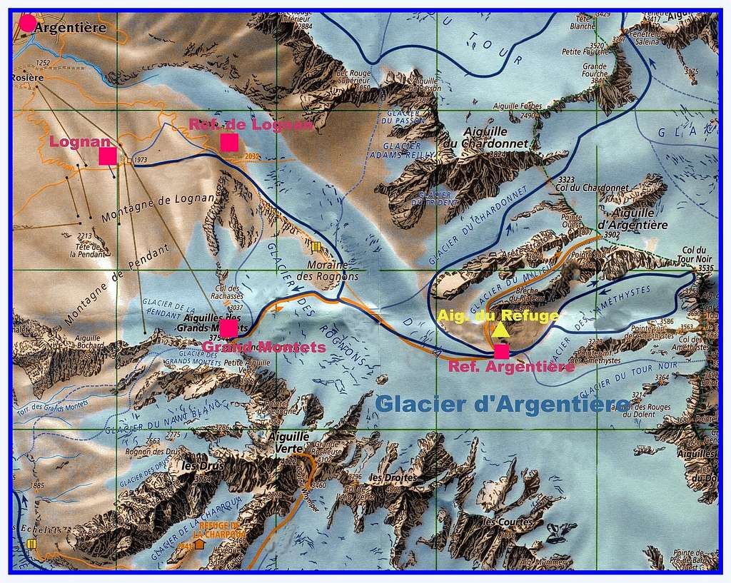
Reach the parking of the Grands Montets cable-car in the village of Argentière. From here there are two possibilities to reach the Refuge d’Argentière, the starting point of all the climbs on the satellites of Aiguille d’Argentière:
- A. Take the Grands Montets cable-car to the middle station (Lognan) m. 1973
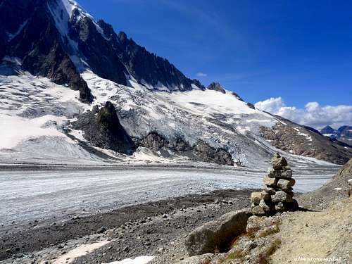
From here follow an unpaved road, then the trail getting the orographic left side moraine (the right hand side by walking) of the Glacier d’Argentière. Walk on the moraine as far as the altitude of 2250 m., lightly descending on a trail getting the flat start of the glacier. Follow briefly the glacier, then again the trail on the moraine as far as a system of iron stairways climbing the slabs overlooking the glacier. Climb the stairways to the summit of the moraine. A good and panoramic path follows the moraine, ending at the junction between the Glacier d’Argentière and the Glacier des Rognons on the right. Downclimb some granite blocks (yellow marks) to get the flat surface of the Glacier d’Argentière, walking at first on the right side, then in the middle, finally traversing to the left side to take a good path leading to the Refuge d’Argentière. Easier but longer approach. From 3,30 to 4 hours from the Cable-Car station.
- B. Take the Grand Montets cable car to the upper station of Grands Montets m. 3297
From the station descent along the Glacier des Rognons, getting the huge blocks (yellow marks) before the junction between this glacier and the Glacier d’Argentière. From here as the previous approach. 2 h from the Cable-car upper station.
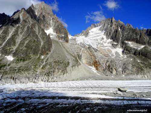
Head of Argentière glacier
Hut
Refuge d’Argentière 2771 m
Owner: C.A.F phone +330450531692
Situation: Mont Blanc group - Northern shore of Argentière Glacier
Open: from beginning of March to middle May and from middle June to middle September
Size: 100 persons + 20 in the winter-shelter
Phone: +330450531692
Getting there: from Argentiere by the Grands Montets cable-car, then by walking
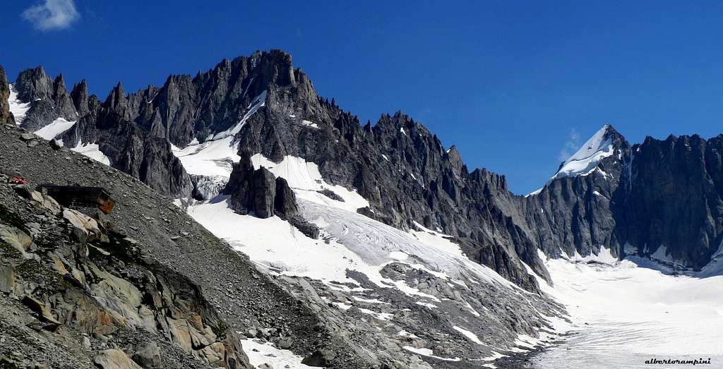
View on Refuge d'Argentière, Pointe Kurtz and Mont Dolent
Red Tape
No particulary restrictions in climbing, mountaineering and hiking.
Route: Le Gateau de Riz report
Le Gateau de Riz, a beautiful trad route on Aiguille du Refuge
Summit altitude: m. 3057
Grade: D sup., French 5c (following the upper direct variants)
Climbing length: 250 m.
Exposure: S
Equipment: some rare pegs; more protection (friends, nuts and slings) along the pitches and to improve the belays is needed
First ascent: M. Piola – A. Muller – B. Wietliesbach 1975
Starting point: Argentière m. 1240 (parking). Cable car Grands Montets (8.00-17.00).
Hut: Refuge d’Argentière m. 2771
An excellent trad route classic style, running on the typical great reddish granite of Mont Blanc group. A complex line, mainly following different kinds of cracks: the distinctive fourth pitch crack - the "Lucky Luke"- is one of these.

Le Gateau de Riz report (French scale)
Approach from Refuge d'Argentiere: just behind the hut take a trail towards North up the grassy slopes, heading towards the obvious spur lying on the left side of the reddish face of the peak.
P1 Climb a crack, then a chimney 4c, 30m. Belay on a good ledge.
P2 From the belay return to the left to the crest, without climbing the dihedral above the belay, then climb a detached flake. Belay on a little terrace. 4b, then 4a 35m.


P3 Follow directly the ridge with easier climb to a belay in a small cave to the right of an overhang, below the characteristic "Lucky Luke" crack 3c, 25 m.
P4 Up directly to catch the "Lucky Luke" crack, climb it with some hard moves, then climb a slab 4c, 15 m.
P5 Directly over the belay 5c, 30m. Belay on a large ledge.
P6 Enter a chimney, then follow an airy crest. 4a, then 3c, 35m.
P7 Cross the gap and gain the bottom of the steep summit tower 3c, 20m.
P8 Climb directly the steep wall above the belay to the summit 5b, 40m.
")

Descent : from the summit a 20 m abseil to North West leads inside the upper part of a steep gully. It's absolutely not recommended to abseil down the gully (slings visible)! The best route is traversing left under some overhangs, at first time mainly on level, then slightly upwards, to get a rocky crest below the summit (3a, 50 mt.), then a large scree gully. Scramble down the gully, keeping to the right at the bottom. The hut is visible!
When to climb

Best season goes from the end of June to the middle of September. Anyhow experienced climbers can climb the sunny South face of Aiguille du Refuge also in late winter and early spring, approaching by ski and obviously using the correct gear.
Where to stay
In addition to the Refuge d’Argentière m. 2771 there is plenty of accomodations in Chamonix Mont Blanc, a primary destination offering several possibilities (hotels, huts, gites, renting rooms). Numberless campsites are situated both in the Northern and Southern ends of the town.
Main campsites:
- Camping Glacier d'Argentière
- Argentière (8 km. North to Chamonix) +33(0)450541736
- Camping la Mer de Glace
- Les Praz (3 km. North to Chamonix) +33(0)450534403
- Camping les Deux Glaciers
- Les Bossons (3 km. South to Chamonix) +33(0)450531584
- Camping les Arolles - close to the centre of Chamonix - +33(0)450531430
- Camping les Cimes
- Les Bossons (3 km. South to Chamonix) +33(0)450535893
- Camping les Marmottes - +33(0)450536124
Meteo
Chamonix Meteo
Meteoswitzerland
Useful information
- Office de la Haute Montagne de Chamonix Phone +33 0450 532208 Office de la Haute Montagne
- Cable-car informations Phone +33 0450 532275 Compagnie du MontBlanc
- Office du Tourisme de Chamonix Phone +33 0450 530024 Chamonix Mont-Blanc
Guidebook and maps

"Monte Bianco classico & Plaisir" by Marco Romelli – Idea Montagna Editoria e Alpinismo
Maps
IGN 3630OT Chamonix - Massif du Mont Blanc
Swisstopo 1344 Col de Balme
Swisstopo 282 Martigny
Swisstopo 46 Val de Bagnes