


-
 50627 Hits
-
 97.38% Score
-
 68 Votes
|
|
Area/Range |
|---|---|
|
|
47.58579°N / 12.29851°E |
|
|
Hiking, Mountaineering, Trad Climbing, Sport Climbing, Big Wall, Scrambling, Via Ferrata |
|
|
Summer, Fall |
|
|
7690 ft / 2344 m |
|
|
1 – Overview
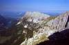
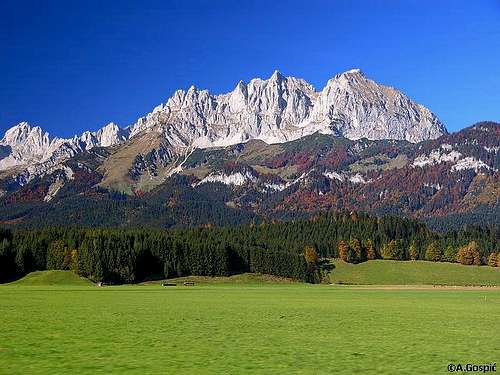
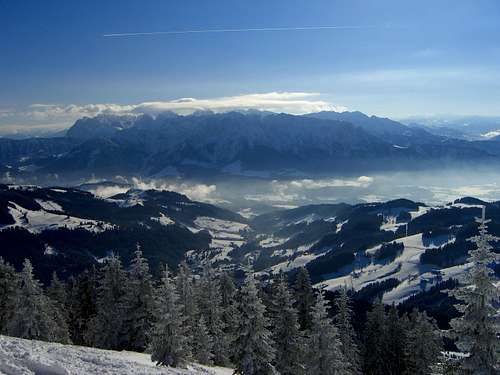 Zahmer and Wilder Kaiser seen from Spitzstein (by Sebastian Hamm) Zahmer and Wilder Kaiser seen from Spitzstein (by Sebastian Hamm) |
Wilder Kaiser and Zahmer Kaiser, together called Kaisergebirge – or simply Kaiser – are among the smallest of mountain ranges in the Alps. Still the names are well known in the mountaineering and climbing community, since climbing history has been written on (or hanging from) their walls and faces. Mainly Wilder Kaiser was the scene of many a historic feat with names like Fleischbank, Predigtstuhl or Totenkirchl dominating the lists. Everyone of rank and name climbed here and at all times the best climbers pushed climbing a step further with new test pieces on these walls. H. Dülfer established the classic Fleischbank Ostwand Route together with W. Schaarschmidt. F. Wiesner climbed here before emigrating to the US and kicking of the climbing movement there. A. Heckmair and L. Vörg practised on the Wilder Kaiser faces before setting out to climb the Eiger north face together with H. Harrer and F. Kasparek. G. B. Piaz, P. Preuss and H. Buhl scored FAs, some of them as improbable solos either around the turn of the 20th century or in post WW II. Though today every crack and cleft seems to have been climbed still there seems to be room for improvement like St. Glowacz’ “Des Kaisers Neue Kleider”, which introduced the 10th degree to the Kaiser.
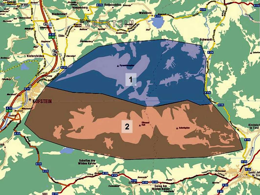
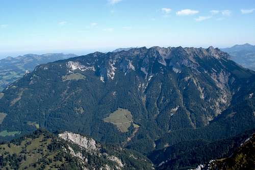
Kaisergebirge consists of two small ranges, both consisting of little more than a single ridge. The characters of the wo ranges couldn’t be more different. Zahmer Kaiser in the north is a smooth sloped, pine covered range, popular among climbers. To the south, divided by the Kaisertal and Kaiserbachtal Valleys, which combine in the Stripsenjoch Saddle you find the wildest of mountain ranges, Wilder Kaiser. It also consists of a single ridge, running from east to west, with several short side ridges, in all about 40 different summits.
2 - Wilder Kaiser Climbing
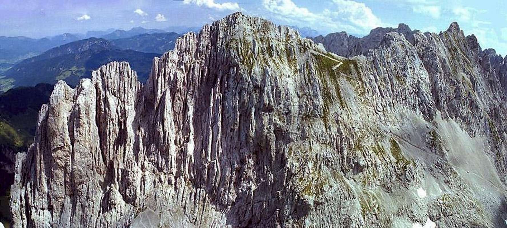
 On Via Classica, Fleischbank
Markus Stadler, who is the author of two climbing guidebooks about Wilder Kaiser (see below) has put together an extensive collection of routes on his own site. I (Gangolf) couldn't resist linking the picture above from his site, which he offers as freely downloadable desktop background.
- Wilder Kaiser Climbing
- Zahmer Kaiser Climbing
Just to get an impression of the wealth of rock climbs, here is a list from a popular guidebook Bayerische Alpen Nordtirol. I'll keep this up to date with links to any trip reports we get here on Summitpost. The table is sorted by difficulty - plug yourself in whereever comfortable for a great time!
| Mountain | Route | Grade | Length |
| Totenkirchl | North side, "Führerweg" | III | 10 pitches |
| Hintere Goinger Halt | North Ridge | III+ | 8 pitches |
| Ellmauer Halt | Kopftörlgrat | III+ | many (15+?) pitches |
| Predigtstuhl | North Ridge "Matejak/Ostler" | IV+ | 18 pitches |
| Totenkirchl | Northeast side, "Heroldweg" | V | 6 pitches |
| Kleine Halt | Nortwestwand "Kaiserführe" | V+ | 27 pitches! |
| Totenkirchl | Totenkirchl Express | VI | 18 pitches |
| Fleischbank | East Wall, "Dülfer" | VI or V/A0 | 15 pitches |
| Fleischbank | Northwest Face, "Via Classica" | V+ | 15 pitches |
| Leuchsturm | Alte Südwand | VI+ or V+/A0 | 12 pitches |
| Fleischbank | "Wiessner/Rossi" | VI+ or V+/A0 | 11 pitches |
| Totenkirchl | Direct West Wall, "Dülfer" | VI+ or V+/A0 | 23 pitches |
| Predigtstuhl | "Schüle + Hasslacher" | VII- or V+/A0 | 10 pitches |
| Vordere Karlspitze | Northeast Ridge / East Wall | VII- | 9 pitches |
In recent years, the Kopfkraxe above Scheffau has become very popular due to the installation of several bolted multipitch routes, mostly created by energetic local Herbert Haselsberger. These are south facing, and thus climbable in shoulder seasons. I'll mention two of the routes here, having climbed both of them and found them generally very fun:
| Route | Grade | Length |
| Via Romantica | VI+ | 15 pitches |
| Blue Moon | VI+ | 11 pitches |
3 - Geology
For the mountaineer, interested in alpine geology, Kaisergebirge is an instructive mountain area. On a south - north traverse, e.g. from Ellmau to Gruttenhütte - Ellmauer Halt - Gamshalt - Kaisertal - Stripsenjoch - Pyramidenspitze - Walchsee, you can
- learn quite a bit about the main stratigraphic members of the Northern Limestone Alps
- learn something about the tectonic nappes of the Northern Limestone Alps
- gain interesting insights in different facies as lagoon sediments, coral reefs, algae reefs and
- learn about mountain building (orogenetic) processes like syncline - anticline building.
The geological history of Kaisergebirge starts in the early Triassic age, about 250 million years ago. In these times existed a huge east - west orientated ocean, called Tethys. All the Triassic and Jurassic sediments, which surface nowadays around and in Kaisergebirge where deposited on the south rim of this ocean ,which means: this happened as far away from nowaday Kaisergebirge location as the today northern Africa is – and even farer!
In early Triassic age terrestrial sediments were deposited, mainly sandstones (Hochfilzener Schichten, Alpiner Buntsandstein), which are lying discordant, oblique, on the layers of the much older Grauwackenzone. This zone is the basement of the Northern Limestone Alps and comes today fully to light in the Kitzbüheler Alpen area.
 The compact rock face of Maukspitze south is a Wetterstein sponge reef
Beginning with the middle Triassic age marine limestone was deposited. These marine sediments show a clear facies difference. Facies means all the characteristics of a rock resulting from and thus showing its genesis.
The marine limestone of the middle and upper Triassic can be divided in shallow water limestone and reef limestone like Wettersteinkalk, interfingered with the corre-sponding basin sediments (Partnachschichten). Wettersteinkalk builds nearly all summits of Wilder Kaiser. The Wetterstein reefs can be studied e.g. at Scheffauer. The northern ascent to Scheffauer from Kaindlhütte (Widauer trail) shows first the limestone beds of the reef lagoon facies of Wettersteinkalk. If you look closer you may discover fossilized green algae tubes of and intertidal sediments with stromatolites (algae layers). Higher up to Scheffauer summit you meet the pre - reef facies with breccia limestone, a sort of fossilized underwater scree fan. Scheffauer summit is the reef itself with fossilized corals and sponges.
Raibler Schichten, marls and thin limestone slabs with fossilized mussels and sea shells, are topping and burying these reef - basin facies.
The next stratigraphic member is Hauptdolomit, a dolomite stone built in a huge shallow lagoon. The Hauptdolomit lagoon was a broad tidal flat and mud flat with huge algae growth. You may see the fine stromatolitic striping caused by growing and dying and growing and dying algae. The high organic compound of these rocks can be seen in the dark colour of the rock and in its sulfuric smell when broken.
Out of this lagoon facies developed another reef complex, Oberrhätkalk with the cor-responding lagoon sediments and basin sediments (Kössener Schichten). The Oberrhät reefs where maily coral reefs so you will find them fossilized.
Jurassic red limestones and manganese schists, overlying Kössener Schichten, show a much deeper basin facies and mark the end of the preserved Triassic - Jurassic stratigraphy. The younger sediments were eroded in the Kaiser region, however, the surrounding regions show these lacking stratigraphic members. These rocks give clear evidence of a marine milieu with mainly huge and deep basins and some shallow water ridges in between.
 You can see the syncline structure of Kaisergebirge: left and below right (Zahmer Kaiser)is Wetterstein limestone like a huge U-shape, in the middleground younger Hauptdolomit
Then the alpine orogenetic processes disturbed and interrupted the sedimentation and changed the whole region slowly and thoroughly. The Tethys ocean was closed by subduction processes and the south rim deposits where transported as tectonic nappes northwards and thrusted over the north rim sediments of the Tethys ocean. Phases of lifting changed with phases of consolidation and erosion. Younger sediments, deposited during different phases of alpine orogenesis, like Gosau deposits or Häringer Schichten, which are mined in the region as cement resource, can be studied within Kaisergebirge, too (Eiberg location).
Kaisergebirge belongs to the Stauffen-Höllengebirgs nappe of the so called Tirolikum, a main tectonic unit of the Northern Limestone Alps. During a rather late oroge-netic phase in Miocene time, Kaisergebirge was lifted up as a tectonic block and - because of south - north vergent pressure - folded to a huge syncline with a west - east axe. The syncline shows a steep to perpendicular south side (Wilder Kaiser; that is why this part is “wild”) and a less steep northern part (Zahmer Kaiser; the tame and gentle Kaiser). Look at the near perpendicular slabs of limestone e.g. around Törl notch or Goinger Halt (see photo of Goinger Halt above). Here you have the south part of the huge syncline whereas the broad limestone plateau of Zahmer Kaiser marks the northern part of the syncline.
This syncline is not a simple structure. The strong pressure caused many fault systems within Kaisergebirge itself. The most remarkable fault system is the breakup between “Hochkaiser”, which is the summit zone of Wilder Kaiser and the “Niederkaiser”, visible at the east end of Kaisergebirge near Sankt Johann in Tirol or at the lower parts of the Kaisergebirge south slope, where “Niederkaiser” rocks form a subsummit, called “Brennender Palven”.
At last, the ice age formed the emerged landscape and, together with land slides and rockfall, created the modern shape of Kaisergebirge.
A good article full of information is available on www.geologie.ac.at, written in German. The geological overview and the historical summary of the geological research within Kaisergebirge might be interesting and understandable for the “ordinary mountaineer”; the explication for the corresponding geological map might be too complicated for the non-geologist. But at the end of the article there are some proposals for field trips, showing interesting places or geological highlights, which can easily be included in day hikes within Kaisergebirge.
4 - Panorama Ackerlspitze
RegalpspitzeRegalpwandTörlwandTörlspitzenTreffauerEllmauer HaltGamshaltV. KarlspitzeH. KarlspitzeV. Goinger HaltTotenkirchlFleischbankH. Goinger HaltPredigtstuhlZahmer Kaiser 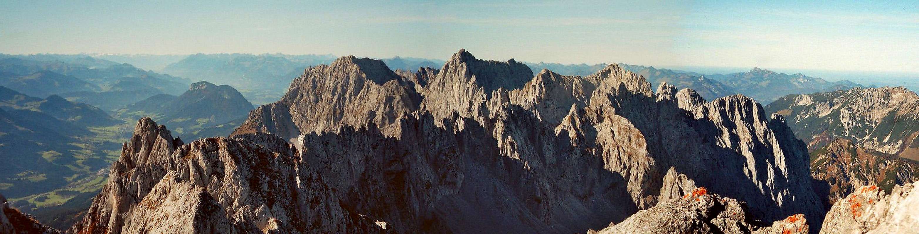  |
5 - Kaisergebirge on SP
|
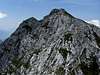
6 - Zahmer Kaiser
 Zahmer Kaiser seen from Scheffauer, picture by mairhofs
Zahmer Kaiser is located in the northern half of Kaisergebirge. Its Summits are located on a long ridge, the highest of them in the eastern part. Vordere and Hintere Kesselschneid as well as Pyramidenspitze are the three highest summits of the range only one of which tops 2000m.
- Teufelskanzel (802m)
- Rogerkopf (1138m)
- Lahnkopf (1204m)
- Zehnerkopf (1241m)
- Gamsschaukopf (1216m)
- Naunspitze (1633m)
- Petersköpfl (1745m)
![]()
- Einserkogel (1924m)
![]()
- Zwölferkogel
![]()
- Elferkogel
- Pyramidenspitze (1997m)
- Vordere Kesselschneid (2001m)
- Hintere Kesselschneid (1995m)
- Jovenspitze (1890m)
- Rosskaiser (1970m)
- Heuberg (1603m)
- Stripsenkopf (1807m)
- Ropanzen (1572m)
- Feldberg (1813m)
- Kohllahnerkopf (1556m)
- Wasserlahnerkopf
- Schneebichl (1470m)
- Scheibenkogel (1614m)
- Zasserlkögerl (1298m)


7 - Wilder Kaiser
TuxeckTreffauerKaiserkopfEllmauer HaltKöpfelTörlspitzeTörlspitzenkammTörlwandRegalpwand/-spitzeAckerlspitzeMaukenspitze 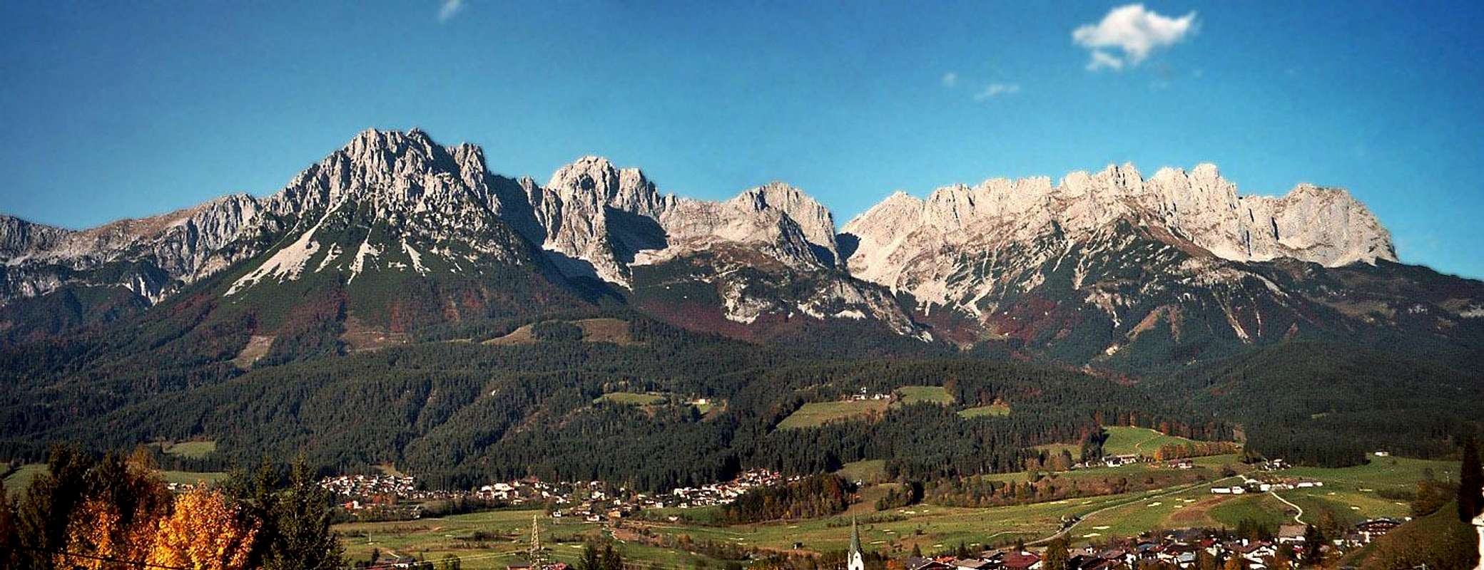 |
Though only a relatively small range, consisting of a single east – west ridge, Wilder Kaiser is divided into four even smaller subranges. One to the east and west each and two in the centre, where the side ridges protrude to north and south. The highest summit of Wilder Kaiser is Ellmauer Halt.
- Zettenkaiserkopf (1609m)
- Zettenkaiser (1960m)
![]()
- Scheffauer (2111m)
![]()
- Hackenköpfe (2125m)
![]()
- Sonnenstein (1714m)
- Wiesberg (1998m)
- Kopfkraxen (2178m)
- Gamskarköpfl (2040m)
- Sonneck (2260m)
- Kleinkaiserl (2219m)
- Treffauer (2304m)
![]()
- Tuxeck (2226m)
- Kaiserkopf (2171m)
7.2 - Halten – Stock
- Elmauer Halt (2344m)
![]()
![]()
- Leuchsturm (2275m)
- Friedrichsturm (2160m)
- Gamshalt (2292m)
- Kleine Halt (2116m)
- Totensessel (1745m)
7.3 - Central Wilder Kaiser
- Vordere Karlspitze (2260m)
- Hintere Karlspitze (2261m)
- Totenkirchl (2190m)
![]()
- Christaturm (2170m)
![]()
- Fleischbank (2187m)
![]()
- Fleischbankpfeiler (1749m)
- Predigtstuhl (2116m)
![]()
- Vordere Goinger Halt (2242m)
![]()
- Hintere Goinger Halt (2192m)
![]()
- Bauernpredigtstuhl (2119m)
- Nördliche Törlspitze (2187m)
![]()
- Goinger Turm (2201m)
- Goinger Törlspitze (2227m)
- Östliches und Westliches Törleck (2198m)
- Höchster Törlturm (2191m)
- Kreuztörlturm (2173m)
![]()
7.4 - Ostkaiser
- Daumen (2151m)
- Törlwand (2197m)
![]()
- Regalmwand (2227m)
![]()
- Regalmspitze (2253m)
![]()
- Regalpturm (2226m)
- Hochgrubachspitzen (2277m, 2284m)
- Ackerlspitze (2329m)
![]()
- Ackerlhüttenturm (1910m)
- Waxensteinerturm (2086m)
- Maukspitze (2231m)
![]()
- Niedersessel (1840m)
- Gamsflucht (2203m)
- Lärcheck (2122m)
- Kaisermanndl (1940m)
- Mitterkaiser (2001m)
- Kleinkaiser (2032m)
- Geschwendtner Turm (2042m)
7.1 - Westkaiser


8 - Getting There
 Eastern part and southern side of Wilder Kaiser (by Velebit)
The popularity of Kaisergebirge mainly stems from the fact that the cities of Munich, Salzburg and Innsbruck are almost equally close to the area, between 75km and 100km. The itineraries all starts at the respective airports and end at Kufstein to the west of the range.
- From Munich
Munich airport is farthest away from Kaisergebirge since it lies on the other (north-eastern) side of the city. From the airport tak A92 in direction Munich. At Kreuz Neufahrn switch to A9 south which you have to leave again at Kreuz München Nord, where you switch to A99, the motorway ring around Munich. At Kreuz München Süd switch onto A8, direction Salzburg until you reach the Inntaldreieck intersection. Switch onto A93, which takes you to Kustein.
- From Salzburg
Take A8 west, direction Munich. At Inntaldreieck switch to A93 south until you reach Kufstein.
- From Innsbruck
Take A12 (Inntalautobahn) east, which will take you directly to Kufstein.
9 - Red Tape
 Posing alpine chough (by Lioba Stenner)
1963 Kaisergebirge was set aside as a natural park, containing an area of 102 km². As a result only one lift has been built in the range and up to early 2006 the Kaisertal Valley to the west of the group was the only inhabited valley without road access in the whole of Austria. However, construction of a road was begun in May of the year. Within the natural park the usual restrictions apply.
10 - Mountain Huts and Refuges
| Refuge / Hut | Height | Summer | Winter | Tel. | Thumbnails |
| Ackerlhütte | 1460 | June - Oct supervised | self service | +43/5356/72022 | |
| Anton-Karg-Haus | 829 | mid May - Oct | closed | +43/5372/62578 | |
| Aschenbrenner Berghaus | 1140 | all summer | all winter | +43/5372/62220 | |
| Babenstuberhütte | 2300 | self service | self service | n.a. | 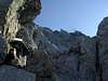 |
| Brentenjochhütte | 1273 | all summer | all winter | +43/5372/65148 | |
| Fritz-Pflaum-Hütte | 1865 | self service | self service | +43/8033/4179 | |
| Gaudeamushütte | 1267 | mid May - mid Oct | closed | +43/5358/2262 | |
| Griesner Alm | 1006 | beg May - end Oct | Dec - March | +43/5352/64443 | |
| Gruttenhütte | 1619 | end May - mid Oct | closed | +43/5358/2242 |  |
| Kaindlhütte | 1318 | 1. May - 1. Nov | closed | +49/173/1958910 | |
| Kaisertal-Haus (Hans-Berger-H) | 936 | mid May - end Oct | closed | +43/5372/62575 | |
| Pfandlhof | 783 | all summer | all winter | +43/5372/62118 | |
| Riedlhütte | 1268 | mid May - end Oct | closed | n.a. | |
| Stripsenjochhaus | 1577 | mid May - end Oct | closed | +43/5372/62579 |  |
| Vorderkaiserfeldenhütte | 1384 | all summer / after Easter closed | all winter / Dec closed | +43/5372/63482 |  |
| Wochenbrunner Alm | 1085 | all summer | all winter | +43/5358/2180 |  |
11 - Accommodation
Each of the towns and villages of the area has a homepage with the possibility to book hotel rooms and apartments. Follow one of the links below.- Ellmau
- Scheffau
- Soell
- Going
11.2 – West / Kufstein
- Kufstein
- Ebbs
- Niederndorf
- Schwoich
11.3 – North / Kaiserwinkl
- Kössen
- Walchsee
11.4 – East / St. Johann
- Erpfendorf
- Kirchdorf
- Oberndorf
- St. Johann
11.1 – South / Wilder Kaiser
12 - Weather Conditions
Kaiserwetter – the term Germans use for perfect weather – though dating back to the German Emperor Wilhelm II, who needed perfect weather for his photo ops – might also have been coined by climbers in Wilder Kaiser – and certainly is used that way today: weather perfect for climbing in the Kaiser.13 - Maps & Books
13.1 - Maps
- Digital Maps
- Regular Maps
- Kaisergebirge
Kompass Map WK 9
1:50.000
ISBN: 3-85491-011-8
- Kufstein, Kaisergebirge, Kitzbühel
Freytag & Berndt Map WK 301
1:50.000
ISBN: 3-8508-4710-1
- Kaisergebirge
Alpenvereinskarte Blatt 8
1:25000
Art.Nr.: 100014
DAV Shop
- Kaisergebirge
13.2 - Books
- Hiking Guides
- Kaisergebirge
Kompass Wanderführer WF905
Walter Theil
Kompass Verlag
ISBN: 3-85491-193-9
- Wilder Kaiser
Rother Wanderführer
Sepp Brandl
Rother Verlag
ISBN: 3-7633-4084-X
- Bergwanderungen, Gipfelziele und Höhenwege im Kaisergebirge
Wilder Kaiser, Zahmer Kaiser und Umgebung
Tobias Sessler
Books on Demand Verlag
ISBN: 3-8334-3435-X
- Kaisergebirge und Kitzbüheler Alpen
Tourenführer
Siegfried Garnweidner
Bruckmann Verlag
ISBN: 3-7654-4382-4
- Kaisergebirge
- Climbing Guides
- Kletterführer Wilder Kaiser
Markus Stadler
Panico Verlag
ISBN: 3-9367-4006-2
- Kletterführer Wilder Kaiser, Band 2
Markus Stadler
Panico Verlag
ISBN: 3-9367-4013-5
- Kletterführer Wilder Kaiser
- Bayerische Alpen Nordtirol (15 routes in the Wilder Kaiser)
Richard Goedeke
Bergverlag Rother
ISBN: 3-7633-3016-X
- Kaisergebirge
Alpenvereinführer Alpin
Horst Höfler / Jan Piepenstock
Rother Verlag
ISBN: 3-7633-1257-9
- Kaisergebirge
Alpenvereinführer Extrem
Pit Schubert
Rother Verlag
ISBN: 3-7633-1272-2
- Wilder Kaiser. Klettergeschichte
Horst Höfler, Pit Schubert
AS Verlag
ISBN: 3-9051-1194-2
14 - Page History
- gha – Page setup
- Dec 3rd, 2006 mvs - A popular climbing route table.
- Mar 3rd 2007 gha - Added Naunspitze to the list
- Mar 5th 2007 gha - Added overview pic Zahmer Kaiser
- May 2007 mvs - Added Fleischbank, and some links.
- Dec 12th 2007 gha - Added Fleischbank, Scheffauer, Pyramidenspitze to the listing
- Feb 2008 mvs - Added Totenkirchl Express to the "quick list" of rock climbs.
- June 2010 mvs - Added information on the new Kopfkraxen south wall climbs
- January 2012 selinunte01 - Added information on the Geology chapter
- March 2012 mvs - Added Predigtstuhl and Nordkante, other links
fossana - Oct 16, 2013 12:32 pm - Voted 10/10
logisticsAdding my notes. The tourist office in Going am Wilden Kaiser has a durable map of Wilder Kaiser with trailheads and easier routes/trails marked. Cost was 4.90€ as of Oct 2013. Detailwise, it was similar to the Kufstein, Kaisergebirge, Kitzbühel, which is about twice as much. If you come late in the season (Oct) the local sports shops will have packed away their climbing gear to make room for ski stuff. You're better off stopping in Munich if you didn't bring what you need. The only local place I found that had the latest edition of the Stadler guide was Lippott in Kufstein (http://www.lippott.com/). At least one grocery store in every village.