
-
 2448 Hits
-
 81.84% Score
-
 14 Votes
|
|
Mountain/Rock |
|---|---|
|
|
41.16367°N / 105.37719°W |
|
|
Trad Climbing, Scrambling |
|
|
Summer, Fall |
|
|
8540 ft / 2603 m |
|
|
Overview
On USGS topo maps, Turtle Rock is the whole "massif" that is the centerpiece of Central Vedauwoo, and it makes sense that the trail circumnavigating it is called Turtle Rock Trail.
However, climbers recognize several of the crags of this complex by individual names, which adds some flavor to the area but, more importantly, helps with the sorting of routes.
Hassler's Hatbox (no idea on the name origin) is one of the most distinguishable crags and has excellent views of the others. In addition to having a scrambling route to its summit, there are several good technical rock routes on it. An interesting feature of the summit is that it has several potholes which can make a scenic picture if it has rained recently.
If you're going to climb at Vedauwoo, you should get Heel and Toe: The Climbs of Greater Vedauwoo, by Skip Harper and Rob Kelman. The Mountain Project page for Vedauwoo is free to use and has a lot of information, but unless you already know Vedauwoo or know exactly what you're looking for, it's hard to navigate. But the book, with all its photos and diagrams, really helps make sense of the area.
Another good source of information on the area is Vedauwoo.org. Also, try the Forest Service site, though it's not good for climbing information.
Vedauwoo is famed for its off-width cracks (and larger than that) and its rough granite. Just about any source on the area that you find will warn you to use tape or be prepared to bleed if you are doing technical climbs. Quite often, people recommend kneepads and/or long pants and sleeves as well.
Please add route pages or detailed information about the climbing routes on this peak!
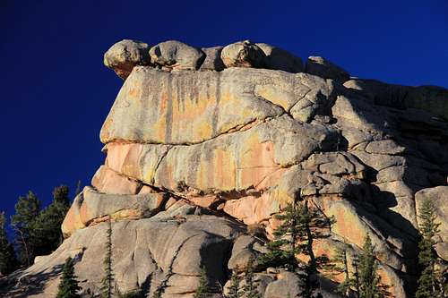
Hassler's Hatbox
Getting There
From I-80 between Laramie and Cheyenne, leave the highway at Exit 329, marked for Vedauwoo. This is about 16 miles from Laramie. Take Vedauwoo Road east and drive 1.2 miles before turning left onto a well-signed road for the Vedauwoo Recreation Area. Stop at the self-pay station and then proceed. Signs point you to the campground, picnic areas, and trailheads. The best trailhead to use for accessing the crags is Box Canyon.
Vedauwoo Road is usually clear of snow by May and sometimes as early as April.
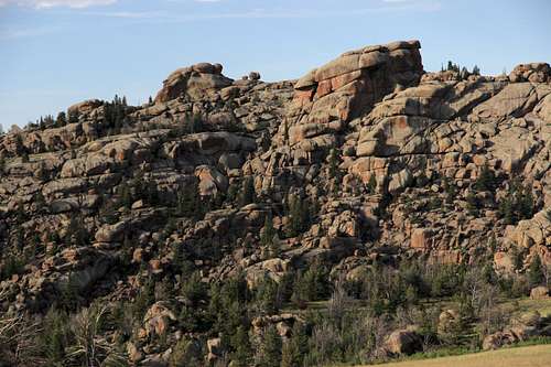
Turtle Rock and Hassler's Hatbox
Climbing Information
Approach
Head up the Box Canyon Trail. Hassler's will come into plain view to the left. Head over and up. Another way to access the formation, especially if you are headed for the technical routes, is to climb one of the lines up Walt's Wall and then head over across the top of the formation.
Rock Climbing
There are 11 established routes, going from 5.6 to 5.12c. Particularly notable routes are Cave Crack (5.6), which involves cracks within a much larger one; Hassler's Hatbox (5.7), supposedly one of the best for its grade in the area; and Lucille (5.12c, but MP calls it d, and the Harper-Kelman guide calls it 13a), reputed to be nearly impossible to climb, even on toprope, but still considered a world-class off-width crack. According to the MP page for Lucille, there have been only 5 ascents of this route.
These are single-pitch routes of about 50' in length.

This picture on Mountain Project shows Pamela Pack, the first woman to climb Lucille, on the route. Note the belayer; it's the climber who's inverted, not the photograph!
Here is a good topo for the routes at Hassler's Hatbox.
Summit Scramble
I found a way up the north side of the formation. It utilized some faces and gullies, and I would put it at Class 4+. Descending, I went a different way and wound up reaching the Turtle Rock Trail near its eastern end, but that involved some Class 5 downclimbing, including through one steep, very tight gully that would be quite difficult to climb going the other way.
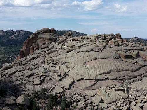 Turtle Rock from Hassler's Hatbox | 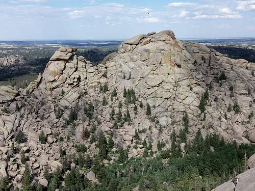 Friction Tower and Old Easy from Hassler's Hatbox |
Red Tape
The self-pay fee was, I think, in July 2014, $5 per vehicle per day. Passes are accepted.
Camping
There is a 28-site campground in the recreation area. It is first-come, first-served and fills quickly on weekends in good weather. Vault toilets and drinking water are available, though in July 2014 the water wasn't flowing or I was just at the wrong pump. The camping fee was $10 per night in July 2014. Closed during the winter, the campground is usually open by the beginning of June.
There is a lot of dispersed camping available nearby, with some restrictions (for example, postings prohibit camping too close to the turnoff for the recreation area.