
-
 4291 Hits
-
 77.48% Score
-
 8 Votes
|
|
Mountain/Rock |
|---|---|
|
|
41.16322°N / 105.37042°W |
|
|
Trad Climbing, Sport Climbing, Bouldering, Scrambling |
|
|
Spring, Summer, Fall |
|
|
8620 ft / 2627 m |
|
|
Overview
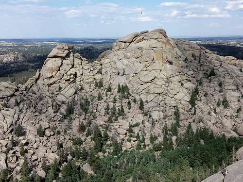
Friction Tower and Old Easy from Hassler's Hatbox
On USGS topo maps, Turtle Rock is the whole "massif" that is the centerpiece of Central Vedauwoo, and it makes sense that the trail circumnavigating it is called Turtle Rock Trail.
However, climbers recognize several of the crags of this complex by individual names, which adds some flavor to the area but, more importantly, helps with the sorting of routes.
Old Easy is the second-highest crag in the complex, with an interpolated elevation of 8620'. It is the peak to the east of the Box Canyon trailhead and the picnic area in Vedauwoo Glen. You can get to the summit with some Class 4 scrambling. The actual Turtle Rock is a bit higher, and it is maddeningly difficult to tell from each of them which is higher, but Old Easy has been determined to be the lower of the two.
Of the highest crags in the Turtle Rock area of Vedauwoo, Old Easy is the easiest to climb; the other three that really stand out go at what I would call Class 4+ at the easiest to at least 5.9.
If you're going to climb at Vedauwoo, you should get Heel and Toe: The Climbs of Greater Vedauwoo, by Skip Harper and Rob Kelman. The Mountain Project page for Vedauwoo is free to use and has a lot of information, but unless you already know Vedauwoo or know exactly what you're looking for, it's hard to navigate. But the book, with all its photos and diagrams, really helps make sense of the area.
Another good source of information on the area is Vedauwoo.org. Also, try the Forest Service site, though it's not good for climbing information.
Vedauwoo is famed for its off-width cracks (and larger than that) and its rough granite. Just about any source on the area that you find will warn you to use tape or be prepared to bleed if you are doing technical climbs. Quite often, people recommend kneepads and/or long pants and sleeves as well.
Please add route pages or detailed information about the climbing routes on this peak!
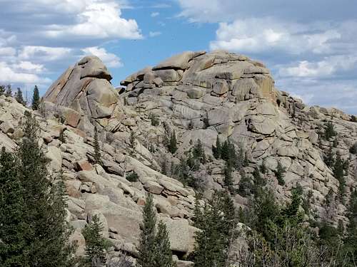
Friction Tower and Old Easy
Getting There
From I-80 between Laramie and Cheyenne, leave the highway at Exit 329, marked for Vedauwoo. This is about 16 miles from Laramie. Take Vedauwoo Road east and drive 1.2 miles before turning left onto a well-signed road for the Vedauwoo Recreation Area. Stop at the self-pay station and then proceed. Signs point you to the campground, picnic areas, and trailheads. The best trailhead to use for accessing the crags is Box Canyon.
Vedauwoo Road is usually clear of snow by May and sometimes as early as April.
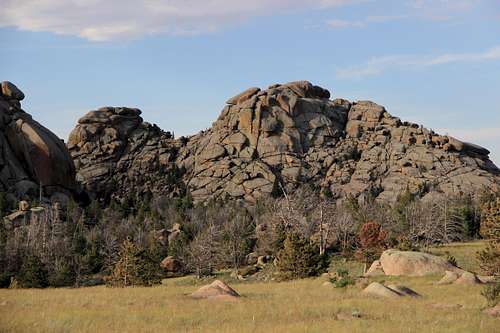
Friction Tower and Old Easy from the access road
Route Information
Rock Climbing
My edition of the Harper-Kelman guide, which is a 1998 printing, subdivides Old Easy into three sections: the MRC Complex, the Golden Triangle, and the Pelvis. In all, the book covers 27 routes among these three sections, all of them trad routes.
As of this page's creation date, the MP page for Old Easy had 19 routes listed and described; more than half were bouldering routes, and the rest were all trad with one sport route.
A classic here is the two-pitch 5.9 MRC Direct, which can be combined with 5.9+ Straight Edge to make a three-pitch route. You can see this route in the left-hand photo below; look for the crack just left of the big overhang.
 MRC Complex | 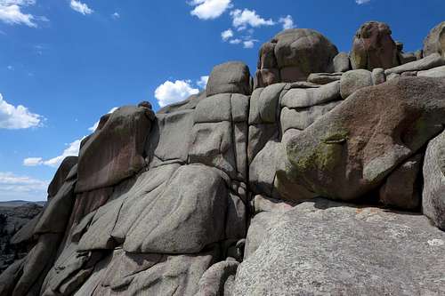 Golden Triangle and Pelvic Areas |
Scramble to the Summit
If you want to get to the summit, head up the Box Canyon Trail a short distance and then depart it and make your way for the face of Old Easy. Using a system of ledges and gullies (some route-finding skills required, as there is no straight line or cairned route), get to the "summit ridge" and route-find your way to the highpoint.
Elevation gain is 400'. The distance is not even a mile. It probably isn't even half a mile.
On both the ascent up the face and the attainment of the highpoint, I encountered Class 4 terrain. While it may be possible that something a little easier may exist, you need to go expecting Class 3 and ready for Class 4.
Views from the top are expansive, taking in Greater Vedauwoo and the surrounding plains.
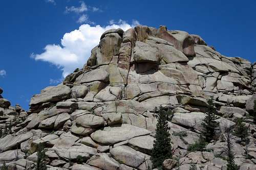
Old Easy Summit
To descend, go back the way you came or make Old Easy just one of several stops as you traverse the "peaks" of the Turtle Rock area. The next-closest peak is Friction Tower, which will require some Class 5 both on the approach to the summit block and then up that block itself.
Red Tape
The self-pay fee was, I think, in July 2014, $5 per vehicle per day. Passes are accepted.
Camping
There is a 28-site campground in the recreation area. It is first-come, first-served and fills quickly on weekends in good weather. Vault toilets and drinking water are available, though in July 2014 the water wasn't flowing or I was just at the wrong pump. The camping fee was $10 per night in July 2014. Closed during the winter, the campground is usually open by the beginning of June.
There is a lot of dispersed camping available nearby, with some restrictions (for example, postings prohibit camping too close to the turnoff for the recreation area.