
-
 6248 Hits
-
 85.36% Score
-
 20 Votes
|
|
Mountain/Rock |
|---|---|
|
|
50.74677°N / 115.08896°W |
|
|
Scrambling |
|
|
Summer, Fall |
|
|
9524 ft / 2903 m |
|
|
Overview
Mount Hood is near the centre of the Opal Range in Kananaskis Country, Alberta, Canada. It is one of the many highpoints along the main range of the Opals that runs from Mount Evan-Thomas south to Elpoca Mountain. This handsome mountain reaches a height of 2903 metres (9,524 ft.) and is the second summit south of Mount Evan-Thomas. Like most Opal Range summits, this peak has named to honour the Battle of Jutland. Named in 1922 for Rear Admiral Sir Horace Lambert Alexander Hood (1870-1916) who was a British admiral of the First World War. His death occurred in 1916 when he went down with his ship, HMS Invincible. First ascent May 1953 by J. Dodds, W. Lemmon and others via North Ridge from Hood/Packenham col.The more famous Mount Hood in Oregon, USA, is also named for a British naval officer; Samuel Hood (1724-1816) was a British Admiral known particularly for his service in the American War of Independence and the French Revolutionary Wars. Considering the fame of the Oregon mountain, the title of this page includes the Opal Range indicator.
Getting There
Easy highway access from Highway 40 along the western edge of the Opal Range provides the best approach. Highway 40 does provide access from the Trans Canada Highway in the north, and continues south to the Longview area, but the southern section is closed for wildlife protection from December 1 to June 15 each winter/spring. Best vehicle access from Canmore/Banff or Calgary is via the Trans Canada Highway, south along Highway 40.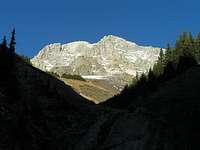
Park in the King Creek parking lot, opposite the turn off for Kananaskis Lakes, approximately 50 km south of the Trans Canada Highway. To gain the West Face of Mount Hood you need to access upper King Creek, which can be difficult as there is no official trail and numerous creek crossings.
Red Tape / Camping and Bivouacs
The parking area and the summit of Mount Hood are located in Peter Lougheed Provincial Park. No permit is required to park or climb in this park. The ascent of Mount Hood is easily completed in a day and a bivouac is not required.Backcountry camping permits are required at all designated backcountry campgrounds anywhere in Kananaskis Country. Overnight permits can be purchased in person at the Barrier Lake or the Peter Lougheed Provincial Park Visitor Information Centres during normal hours of operation.
When to Climb
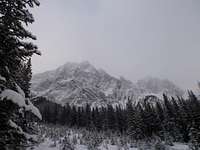
Typical Canadian Rockies situation with July and August providing the best conditions for high elevation climbing. Mount Hood’s relatively low elevation and position in the dry front ranges extends the summer season and is usually dry from June to late October.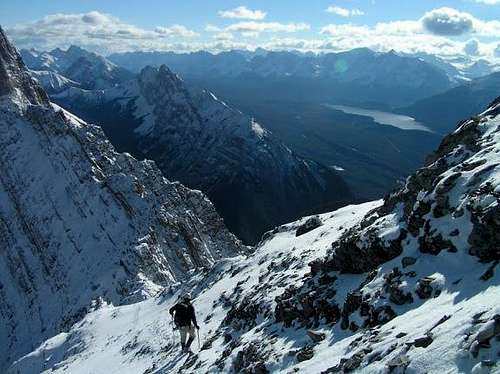 October Ascent
Approach
Park in the King Creek parking lot, opposite the turn off for Kananaskis Lakes, approximately 50 km south of the Trans Canada Highway. To gain the West Face of Mount Hood you need to access upper King Creek, which can be difficult as there is no official trail and numerous creek crossings. |
 |
 |
|---|
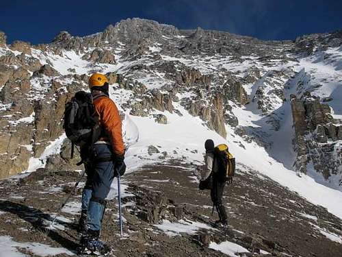
An excellent trail heads up King Creek, but the trail does not have any permanent bridges. Between ice climbers in the winter, and the occasional hiker, the trail usually has many high quality log bridges, but these get fewer and fewer as you head up stream. After about 1.5 kilometres from the parking lot, the creek splits into two branches, turn north (left) and stay low, close to the creek using game trails with some light bushwhacking. About 3.5 kilometres from the left turn, you approach tree line and the Hood/King Creek Ridge Col. Access the West Face from tree line near the col.
Route Descriptions
Three routes have been documented on Mount Hood. The route I used to ascend the peak was a variation of the popular scramble route published in the Alan Kane book. The southern portion of the West Face is generally straightforward and provides several options for ascent/descent. Winter Summit Winter Summit |
 Checking out the West Face Checking out the West Face |
|---|
- North Ridge, Alpine II
Line of the first ascent of the mountain in May 1953 by J. Dodds, W. Lemmon and others from the Hood/Packenham col. From col North Ridge followed until steep steps, West Face traversed to avoid step. Finished via North Ridge.
- West Face/North Ridge, Alpine II
August 1969, J. Jones and J. Martin climbed the central gully system. The top headwall avoided by traversing to the North Ridge which was followed to summit, descent by South Ridge.
- West Face/South Ridge, Alpine I
First ascent of route unknown. The southern portion of the West Face is generally straightforward and provides several options for ascent/descent. From grass slopes below the West Face, the standard scramble route picks a line up a scree gully, left of a steep wall, then up mostly scree to the low point of the Hood/Brock Col. From the col, head just over the ridgeline to easier terrain on the east side of the crest. Stay on scree/slab right (east) of the ridge (3rd class climbing, moderate scrambling) to the summit slopes with are scree or snow depending of time of year. Descend the same route.
During an April ascent, there were questionable snow conditions on the standard scramble route. I chose a steeper line to avoid the snow, further north, using rock buttresses to circumvent most of the snow, climbed several short steps up to 5.5 on solid limestone, crossing small snow slopes in between these steps. My scramble ended further north, and accessed the South Ridge closer to the summit slope (SE slope). On my ascent, the final summit slope had a beautifully consistent water ice base layer and about boot top deep soft snow, crampons were a necessity. Descended the same route.
Reference
Alan Kane's book, Scrambles in the Canadian Rockies, provides excellent route and approach information.Boles, G.W., Kruszyna R. & Putnam W.L. (1979). The Rocky Mountains of Canada South. 7 th edition. New York: American Alpine Club, Alpine Club of Canada.
Out of print