
-
 5982 Hits
-
 79.78% Score
-
 11 Votes
|
|
Mountain/Rock |
|---|---|
|
|
50.68671°N / 115.03981°W |
|
|
Scrambling |
|
|
Summer, Fall |
|
|
9350 ft / 2850 m |
|
|
Overview
‘Mount Schlee’ (GR 385168) is located in the southern end of the Opal Range in Kananaskis Country. It is one the many highpoints along the main range of the Opals that runs from Mount Evan-Thomas south to Elpoca Mountain. This beautiful mountain reaches a height of 2850 metres (9,350 ft.) and is the second high point north of Elpoca Mountain.This summit had the unofficial name of Mt. Schlee applied by Glen Boles after his team’s first ascent of the peak in 1976 (F.A. team D. Forest, G. Scruggs, G. Boles and M. Simpson via South-East Slopes/South Ridge). Gerrit Schlee was a friend of Boles and lost his life trying to save someone drowning in the Bow River in 1975. GR denotes grid reference of the Universal Transverse Mercator (UTM) National Topographic System of Canada (NTS).
Getting There
Easy highway access from Highway 40 along the western edge of the Opal Range provides the best approach. Highway 40 does provide access from the Trans Canada Highway in the north, and continues south to the Longview area, but the southern section is closed for wildlife protection from December 1 to June 15 each winter/spring. Best vehicle access from Canmore/Banff or Calgary is via the Trans Canada Highway, south along Highway 40.Access to the parking area, Elbow Lake trailhead, is affected by the road closure is not accessible by motor vehicle from December 1 to June 15. Park in the Elbow Lake parking lot, approximately 62 km south of the Trans Canada Highway. To gain the South East slopes of ‘Mt. Schlee’ you need to access upper ‘Piper Creek’ (unofficial name), which can be difficult as there is no official trail and a significant river crossing. Once in the upper drainage of ‘Piper Creek’, head north towards a high col (outlier of Mt. Jerram and Mt. Tombstone col) about 1.5 kilometre before the col access to the South East slopes of ‘Mt. Schlee’ is straightforward.
Red Tape / Camping and Bivouacs
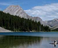 Elbow Lake
The parking area and the summit of ‘Mount Schlee’ are located in Peter Lougheed Provincial Park. No permit is required to park or climb in this park. The ascent of ‘Mount Schlee’ is easily completed in a day and a bivouac is not required.
Backcountry camping permits are required at all designated backcountry campgrounds anywhere in Kananaskis Country. A very popular campground with great views and a short approach is located on the approach to Schlee at Elbow Lake. Overnight permits can be purchased in person at the Barrier Lake or the Peter Lougheed Provincial Park Visitor Information Centres during normal hours of operation.
When to Climb
 November ascent
Typical Canadian Rockies situation with July and August providing the best conditions for high elevation climbing. ‘Mount Schlee’ relatively low elevation and position in the dry front ranges extends the summer season and is usually dry from June to late October.
Approach
From the Elbow Lake trailhead (not accessible by motor vehicle from December 1 to June 15) take the very large trail (former road) to Elbow Pass and beyond to Elbow Lake. The lake is reached quickly as it is only 1.0 kilometre from the parking lot. The large trail continues north along the north shore of picturesque Elbow Lake. The trail soon splits into a hiker’s and horse’s trail, stay on the trail with bridges, this is the hiker trail. Soon spectacular views of the East Face of Elpoca Mountain are visible, including the striking ‘Elpoca Tower’ (GR 401140).On the left side, north side, of the trail, the young Elbow River begins to cut a deeper and deeper sharp valley into the terrain. The sooner you head into the ‘Piper Creek’ valley, the less water and less steep creek bank you will need to negotiate. About 2.0 kilometres north of Elbow Lake (at approximately GR413140), a good flat section with small willows provides a point to cross the Elbow River.
 Tombstone Peaks
An excellent trail heads north/south in the ‘Piper Creek’ valley (I suspect pounded in by the numerous backcountry guided horse trips in the surrounding valleys). The trail is on the north creek bank, best way to find this trail is to head north (light bushwhacking) taking a straight line to the South Ridge of Tombstone South (GR407165). Cross ‘Piper Creek’ and keep heading north until you intersect the trail. Once on the trail, follow it north/north west upstream.
Depending where you intersect this trail, head up valley for about 2 kilometres, and at tree line, head west across alpine meadows to the South East slopes of ‘Mount Schlee’ (GR 385168).
Route Description
One climbing route has been documented on ‘Mount Schlee’ (GR 385168):- South East Slopes/South Ridge, Alpine I
Line of the first ascent in August 1976. On a sunny summer or fall day, the South-East Slopes are simple Class 3 (moderate scrambling) with most of the South-East Slope being loose scree, with sections of elevated ramps with thin scree coverage on slab where care is required. This steep scree slope intersects the South Ridge, where a few steep steps exist along the summit ridge with up to Class 4 (difficult scrambling) on loose rock, but these can be avoided by dropping lower. Descend the same route.
 route marked route marked |
 summits marked summits marked |
 route marked route marked |
|---|
Reference
Boles, G.W., Kruszyna R. & Putnam W.L. (1979). The Rocky Mountains of Canada South. 7 th edition. New York: American Alpine Club, Alpine Club of Canada.Out of print